Archive for the ‘aprs’ Category
 There’s a new radio hobby magazine in town!
Recently, a number of hobby radio magazines have either retired, or have merged into a digital mix of several. Filling that void is the new The Spectrum Monitor, a creation of Ken Reitz KS4ZR, managing editor for Monitoring Times since 2012, features editor since 2009, columnist and feature writer for the MT magazine since 1988. Ken offers this digital, radio communications magazine monthly. The web site is at http://www.thespectrummonitor.com/

The Spectrum Monitor magazine – get your’s, today.
Ken, a former feature writer and columnist for Satellite Times, Satellite Entertainment Guide, Satellite Orbit magazine, Dish Entertainment Guide and Direct Guide, is also contributing editor on personal electronics for Consumers Digest (2007 to present). He is the author of the Kindle e-books “How to Listen to the World” and “Profiles in Amateur Radio.”
The Spectrum Monitor Writers’ Group consists of former columnists, editors and writers for Monitoring Times, a monthly print and electronic magazine which ceases publication with the December, 2013 issue. Below, in alphabetical order, are the columnists, their amateur radio call signs, the name of their column in The Spectrum Monitor, a brief bio and their websites:
Keith Baker KB1SF/VA3KSF, “Amateur Radio Satellites”
Past president and currently treasurer of the Radio Amateur Satellite Corporation (AMSAT). Freelance writer and photographer on amateur space telecommunications since 1993. Columnist and feature writer for Monitoring Times, The Canadian Amateur and the AMSAT Journal. Web site: www.kb1sf.com
Kevin O’Hern Carey WB2QMY, “The Longwave Zone”
Reporting on radio’s lower extremes, where wavelengths can be measured in miles, and extending up to the start of the AM broadcast band. Since 1991, editor of “Below 500 kHz” column forMonitoring Times. Author of Listening to Longwave (http://www.universal-radio.com/catalog/books/0024u.html). This link also includes information for ordering his CD, VLF RADIO!, a narrated tour of the longwave band from 0 to 530 kHz, with actual recordings of LW stations.
Mike Chace-Ortiz AB1TZ/G6DHU “Digital HF: Intercept and Analyze”
Author of the Monitoring Times “Digital Digest” column since 1997, which follows the habits of embassies, aid organizations, intelligence and military HF users, the digital data systems they use, and how to decode, breakdown and identify their traffic. Web site: www.chace-ortiz.org/umc
Marc Ellis N9EWJ, “Adventures in Radio Restoration”
Authored a regular monthly column about radio restoration and history since 1986. Originally writing for Gernsback Publications (Hands-On Electronics, Popular Electronics, Electronics Now), he moved his column to Monitoring Times in January 2000. Editor of two publications for the Antique Wireless Association (www.antiquewireless.org): The AWA Journal and the AWA Gateway. The latter is a free on-line magazine targeted at newcomers to the radio collecting and restoration hobbies.
Dan Farber ACØLW, “Antenna Connections”
Monitoring Times antenna columnist 2009-2013. Building ham and SWL antennas for over 40 years.
Tomas Hood NW7US, “Understanding Propagation”
Tomas first discovered radio propagation in the early 1970s as a shortwave listener and, as a member of the Army Signal Corps in 1985, honed his skills in communications, operating and training fellow soldiers. An amateur Extra Class operator, licensed since 1990, you’ll find Tomas on CW (see http://cw.hfradio.org ), digital, and voice modes on any of the HF bands. He is a contributing editor for CQ Amateur Radio (and the late Popular Communications, and CQ VHF magazines), and a contributor to an ARRL publication on QRP communications. He also wrote for Monitoring Times and runs the Space Weather and Radio Propagation Center at http://SunSpotWatch.com. Web site: http://nw7us.us/ Twitter: @NW7US YouTube: https://YouTube.com/NW7US
Kirk Kleinschmidt NTØZ, “Amateur Radio Insight”
Amateur radio operator since 1977 at age 15. Author of Stealth Amateur Radio. Former editor,ARRL Handbook, former QST magazine assistant managing editor, columnist and feature writer for several radio-related magazines, technical editor for Ham Radio for Dummies, wrote “On the Ham Bands” column and numerous feature articles for Monitoring Times since 2009. Web site: www.stealthamateur.com.
Cory Koral K2WV, “Aeronautical Monitoring”
Lifelong air-band monitor, a private pilot since 1968 and a commercial pilot licensee since 1983, amateur radio licensee for more than 40 years. Air-band feature writer for Monitoring Times since 2010.
Stan Nelson KB5VL, “Amateur Radio Astronomy”
Amateur radio operator since 1960. Retired after 40-plus years involved in mobile communications/electronics/computers/automation. Active in radio astronomy for over twenty years, specializing in meteor monitoring. Wrote the “Amateur Radio Astronomy” column for Monitoring Timessince 2010. A member of the Society of Amateur Radio Astronomers (SARA). Web site: www.RoswellMeteor.com.
Chris Parris, “Federal Wavelengths”
Broadcast television engineer, avid scanner and shortwave listener, freelance writer on federal radio communications since 2004, wrote the “Fed Files” column for Monitoring Times.http://thefedfiles.com http://mt-fedfiles.blogspot.com Twitter: @TheFedFiles
Doug Smith W9WI, “The Broadcast Tower”
Broadcast television engineer, casual cyclist and long distance reception enthusiast. “Broadcast Bandscan” columnist for Monitoring Times since 1991. Blog:http://americanbandscan.blogspot.com Web site: http://w9wi.com
Hugh Stegman NV6H, “Utility Planet”
Longtime DXer and writer on non-broadcast shortwave utility radio. Former “Utility World” columnist for Monitoring Times magazine for more than ten years. Web site: www.ominous-valve.com/uteworld.html Blog: http://mt-utility.blogspot.com/ Twitter: @UtilityPlanet YouTube: www.youtube.com/user/UtilityWorld
Dan Veeneman, “Scanning America”
Software developer and satellite communications engineer writing about scanners and public service radio reception for Monitoring Times for 17 years. Web site: www.signalharbor.com
Ron Walsh VE3GO, “Maritime Monitoring”
Retired career teacher, former president of the Canadian Amateur Radio Federation (now the Radio Amateurs of Canada), retired ship’s officer, licensed captain, “Boats” columnist and maritime feature writer for Monitoring Times for eight years. Avid photographer of ships and race cars.
Fred Waterer, “The Shortwave Listener”
Former “Programming Spotlight” columnist for Monitoring Times. Radio addict since 1969, freelance columnist since 1986. Fascinated by radio programming and history. Website: http://www.doghousecharlie.com/
Thomas Witherspoon K4SWL, “World of Shortwave Listening”
Founder and director of the charity Ears To Our World (http://earstoourworld.org), curator of the Shortwave Radio Archive http://shortwavearchive.com and actively blogs about shortwave radio on the SWLing Post (http://swling.com/blog). Former feature writer for Monitoring Times.
Tracking wildlife
I watching a wildlife programme on TV the other day which had a feature about urban foxes. The naturalists had fitted radio collars to some of the foxes and were able to track them over a wide area.One fox went off on a trek that lasted a couple of weeks and covered a distance of several kilometres.
In another programme radios have been attached to larger birds such as geese and ospreys to track their migration paths.
I wonder what frequency is used? One of the maturalists in the urban fox project seemed to be trying to DF a fox using what looked auspiciouslylike a 3 element 2m Yagi. I’ve seen similar antennas used o locate larger animals in Africa.
I would love to know what technology they use. My Kenwood TH-D7E APRS radio – despite being too big to use as a tracker for anythimg much smaller than an elephant – can run for only a few hours with the GPS enbled and the power set to a sufficient level to enable tracking over a reasonable distance.using a less than optimal transmitting ntenna.
Radio shield woes

This rather grainy photo is probably going to be the last one of the Radio Shield. Mainly because of its un-christmas like behavior. the little monster has been misbehaving for a a while. It decides when and if it wants to decode any packets, which is pretty mean if you ask me and to cap it off a new fault has occurred, the LCD screen is very intermittent. The way it works is a bit like this.
1. Plug it in and watch it power up and display the splash screen – all good so far
2. Turn on the rig and tune into 144.800MHz
3. Send it a packet from my VX-8G and watch the LED flash green to say its happy listening and then display the callsign, SSID and associated data
4. turn it off and enjoy some dinner
5. Turn it back on. Get the usual start up message
6. Do nothing else regardless of what I throw at it.
The really annoying thing is that the serial monitor displays other messages that should go onto the LCD bu they stubbornly don’t bother to show themselves. There is definitely a fault somewhere on here so I’ve had to email Argent Data for a bit of a clue. Other little issues are that you can set the contrast or brightness by code (which you should be able to do).
It seems as though you get intermittent packet decoding and intermittent LCD displays, even if you wire up a few others to test. Hmmmm, perhaps I’ll tackle the other parts to the code enhancements later.
Humbug
My APRS broadcasts received by the ISS
I screen capped the evidence from the website http://ariss.net which documents Amateur Radio data digipeated by the ISS. In order to appear on the page, a position report in a valid APRS format must be received and then digipeated through the ISS system, then be heard by an internet gateway station, which then forwards it on to the APRS Internet System.
Okay it sounds a bit more impressive when put like that ;-)
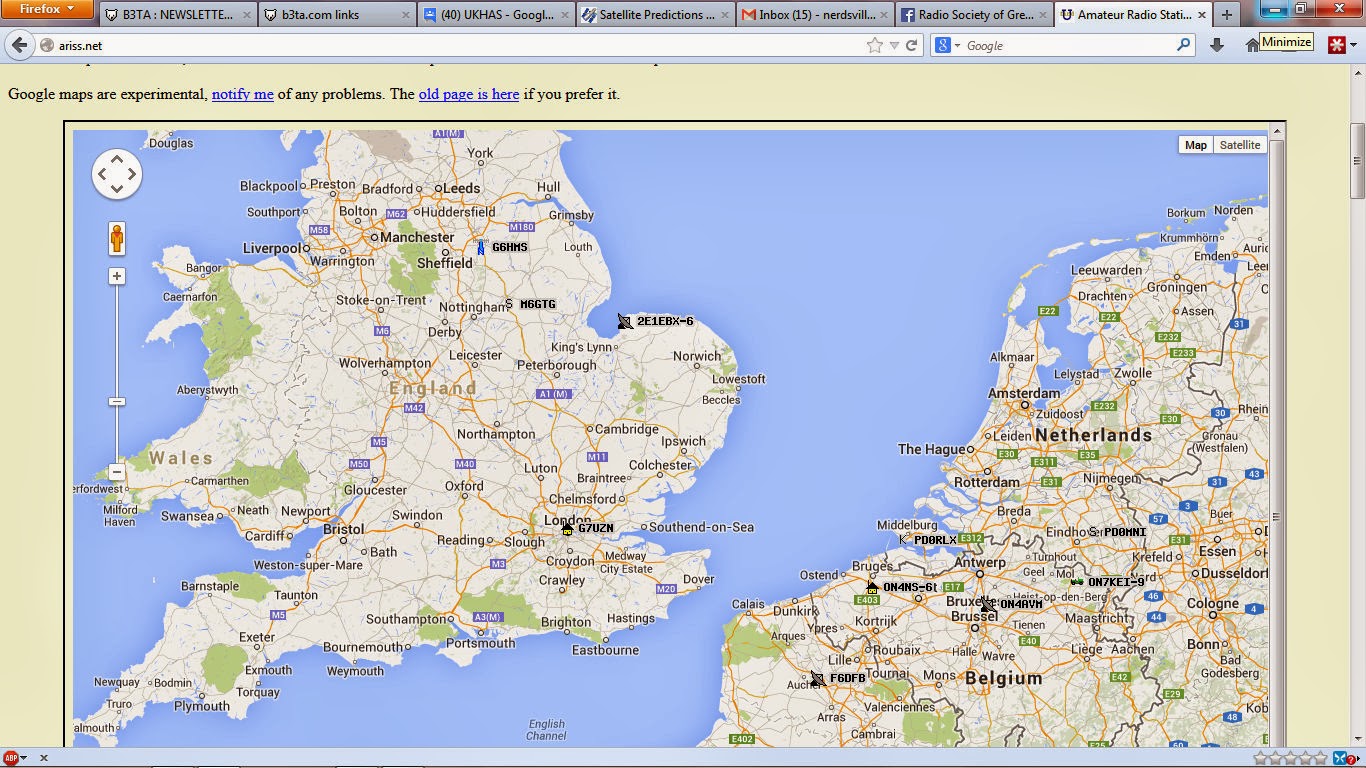 |
| The map showing received stations, M6GTG is me! |
 |
| The detail of my report |
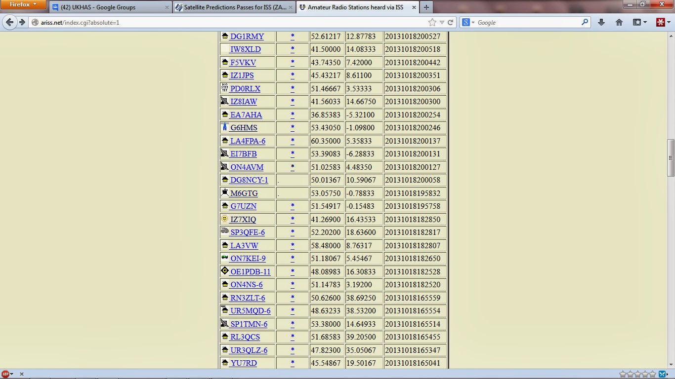 |
| List of stations with time stamps, showing me! |
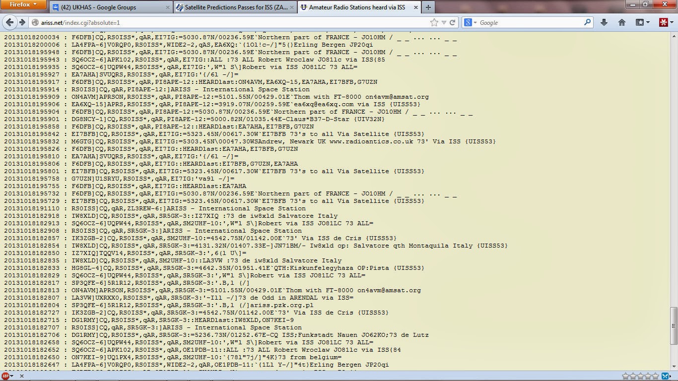 |
| List of digirepeated messages |
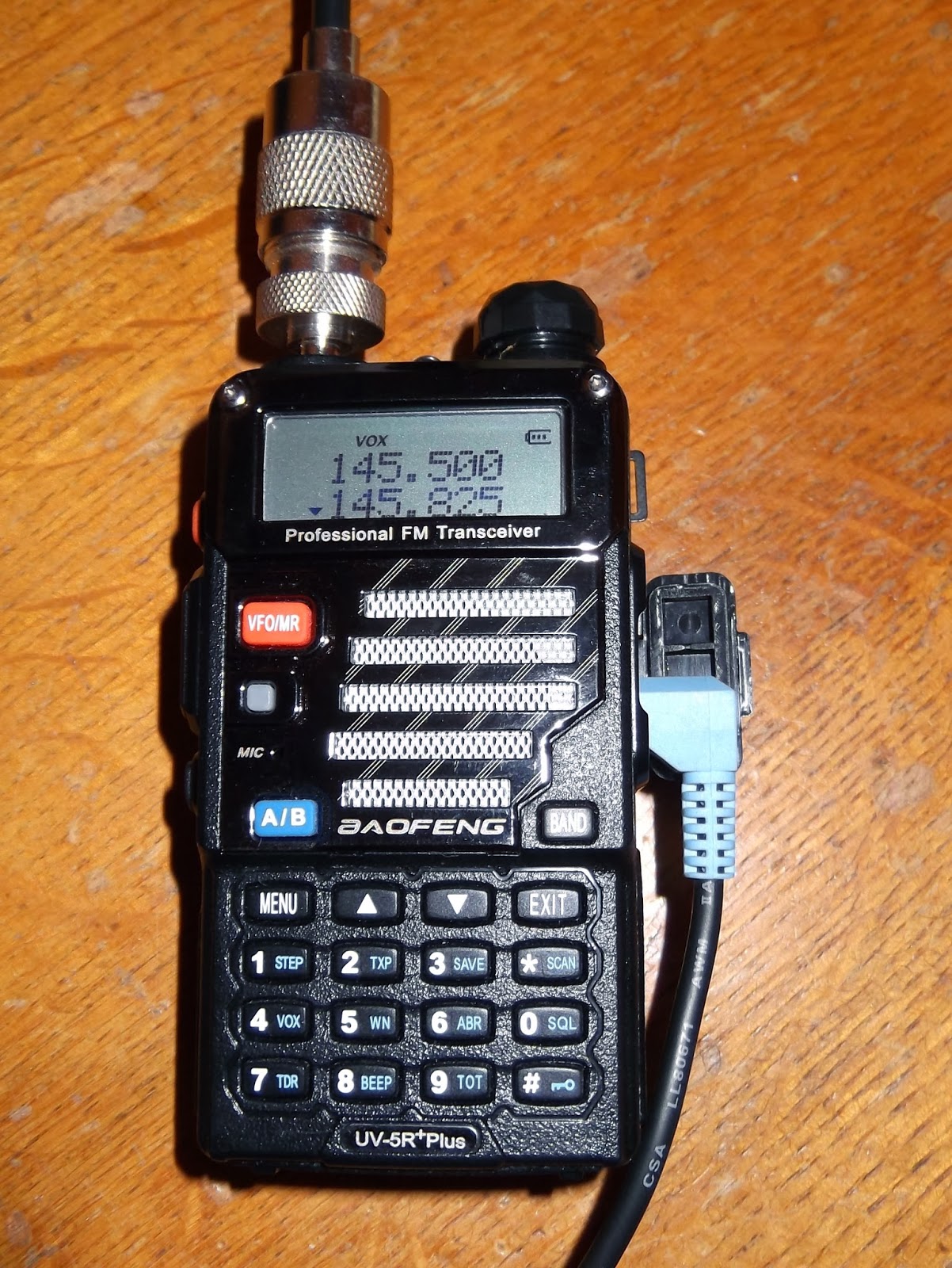
It consists of a small embedded PC running embedded XP, the sound card output was connected to the microphone input of my Baofeng UV-5R+ operating in VOX mode set to 145.825MHz. The radio was connected through my power/SWR meter in to the X-50 antenna. I used the UV-5R+ instead of the UV-3R since it has a little more power and better audio. I had a SWR of around 1:1.2 and outputting 4W.
The software I used was UISS from ON6MNU and the AGWPE packet engine. It has taken a little time to work out how to setup UISS into auto-beacon mode and putting in the time of the next decent pass (approx 45 degrees elevation) I set it to broadcast position and text data messages every 30 seconds.
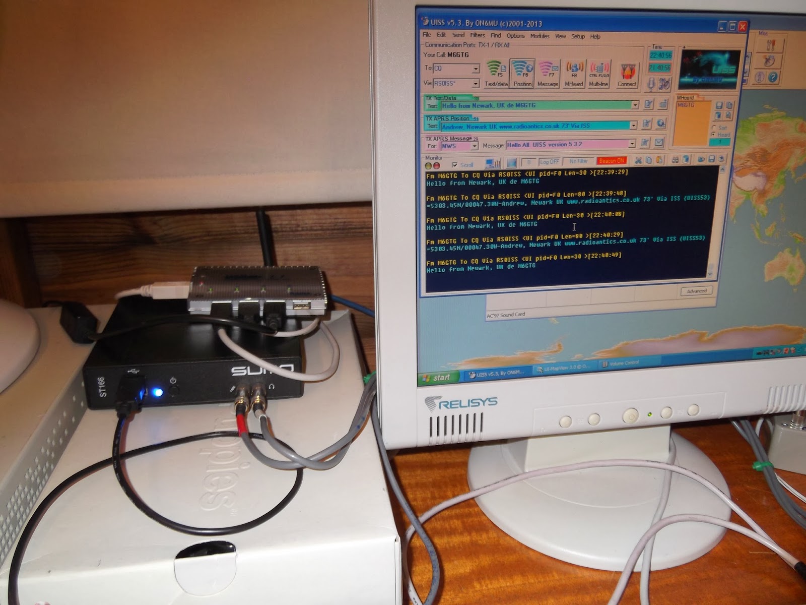 |
| The embedded PC running UISS |
 |
| UV5R+ in VOX mode on 145.825MHz |
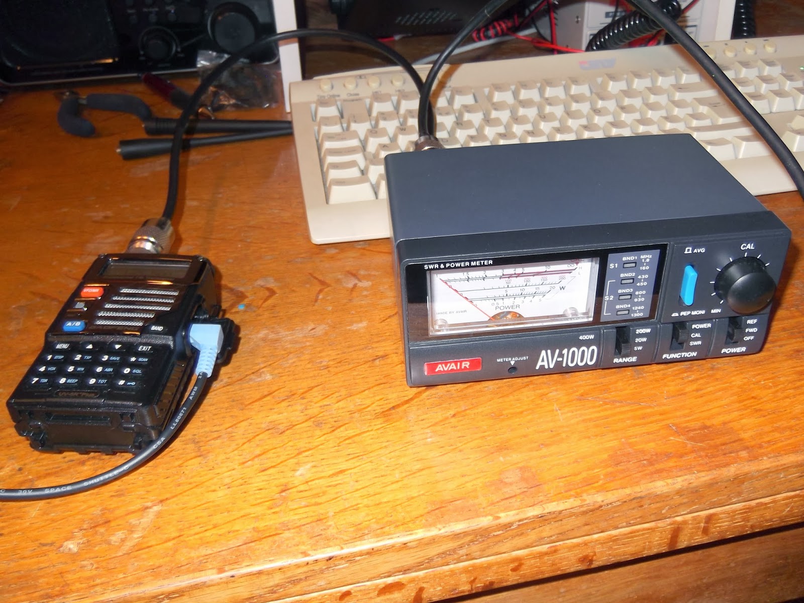 | ||
| The power meter showed 4W output, SWR about 1:1.2 |
I stood out in the dark, hoping to see the ISS pass over but the cloud cover was too thick and monitored using a handheld scanner. I heard my transmissions obviously and the ISS broadcasts as it repeated received messages, but I didn't know if any were mine till I got back to the PC.
Two SOTA Activations: W0/SP-099 and SP-115
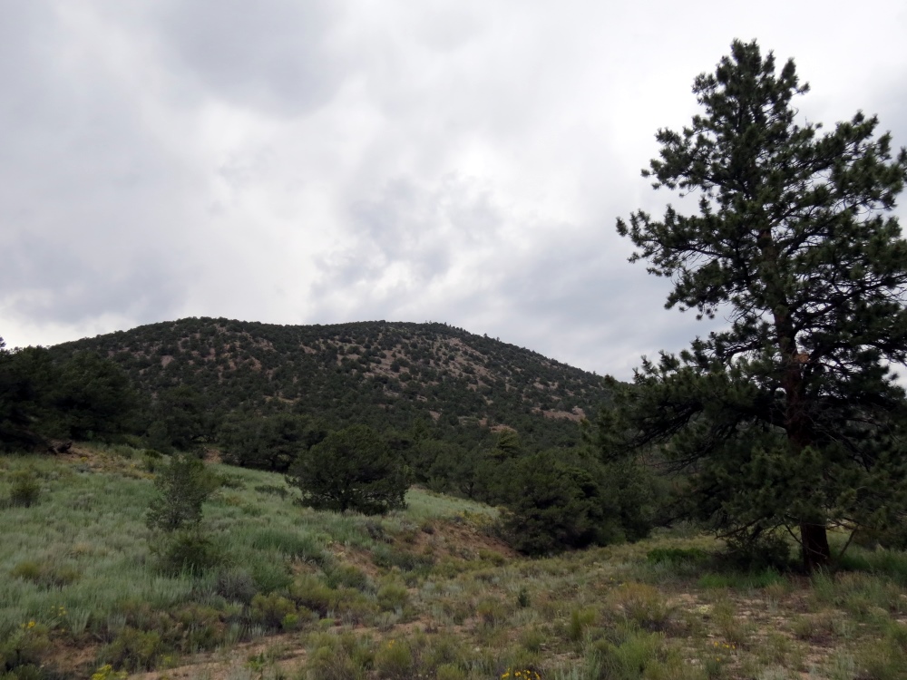
Bald Mountain (W0/SP-115)
Lately, I have been focusing on activating the SOTA (Summits On The Air) peaks near our cabin in the mountains. The basic idea is to identify a SOTA summit, hike to the top and make a few contacts on VHF. On Friday, my spousal unit (Joyce, K0JJW) and I decided to head out to an unnamed peak (W0/SP-099), southeast of Buena Vista, CO. By no coincidence, this summit had not been activated yet, so we’d get the esteemed honor and glory of being the first.
For lesser known summits, a bit of research is required to figure out the route. My first stop is to check the SOTA database for basic information on the summit. I’ll usually have to dig further using ListsOfJohn and SummitPost. ListsOfJohn is an incredible database of topographical information, listing every summit along with information such as elevation, lat/lon, rise, etc. (The Colorado SOTA information was gleaned from ListsOfJohn.) SummitPost will usually have more detailed information on a summit but only for the more popular ones. The SOTA Mapping Project is another excellent resource with very useful interactive topo maps. And, of course, I also dig out the US Forest Service map for the area, which often gives the best view of access roads.
We drove the Jeep to within a mile of the summit and started hiking up. I posted our route information on ListsOfJohn, so take a look there for that information. The summit is unnamed, so it is referred to by its elevation: 10123. I had my Yaesu VX-8GR burping out APRS packets which were plotted on aprs.fi when we reached the summit.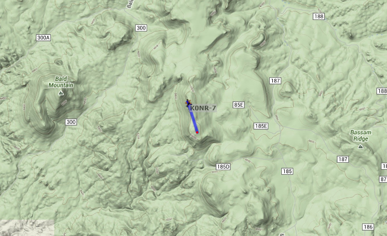
When we reached the summit, I spotted myself on the SOTAWatch web site using the SOTA Goat app on my smartphone. More importantly, the night before the hike, I sent an email to some of the radio amateurs that were likely to be within VHF range. That paid off and I worked Jim KD0MRC, Walt WZ0N and John K3NOQ on 146.52 MHz FM. Jim was hiking to Harvard Lakes above 10,000 feet, so it was special to be able to contact him on the trail. A little later, I caught KV4AL who was mobile near the top of Mount Evans. While only one contact is required to “activate” a summit, four contacts are needed to earn SOTA points, so I was happy to make these four QSOs. My gear was a Yaesu FT-60 driving a 3-element Arrow yagi antenna.
In addition, Joyce and I generally work each other on the SOTA the summit. The SOTA rules say that “QSOs with others within the same Activation Zone do not count towards the QSO total” which means that one of us needs to hike down a bit to get outside of the activation zone (75 feet vertical feet from the summit). We take turns doing this so that each of us activates the summit and makes a contact with the summit.
We took a round about path back to the Jeep and headed for Bald Mountain. At this point, we were both very tired and the thunderstorms were moving in. We decided to at least check out the access to Bald Mountain (Wo/SP-115) even if we didn’t climb it that day. It turns out that there is a 4WD road that goes to the top of the mountain, so we drove to the summit. The road is very rough in a few spots but the Jeep handled it nicely. At the top, we hiked back down a bit to meet the non-motorized ascent requirement for SOTA. We also did our “work each other” technique while on the mountain so that we each had a contact. I was not able to raise anyone on 146.52 MHz but I did catch Carl K5UK on the 146.745 MHz repeater and worked him on simplex. By this time, it was raining with lightning getting closer, so we abandoned the summit and headed back to the cabin.
Thanks to the guys that took the time to contact us on the two summits.
73, Bob K0NR
Argent Data Radio Shield
I’m a bit of an Arduino fan. I’m also interested in APRS. So I was keen to get hold of something that would bring the two together. Enter the Argent Data Radio Shield
I bought one a while ago and used it to make my shack clock. Arduino’s come in a lot of shapes and sizes but the Uno is probably the simplest. You can add bits and bobs to them through stack-able ‘shields’. One of these shields is the Argent Data radio Shield. I ordered mine before going on holiday and got a bit done over on the customs charges but have assembled the little thing and put together one of the simple sketches to show the thing working.

All ready on the bench
All in all the assembly was pretty straightforward with a few parts to put together and not a lot else. You don’t get much in the way of guidance but the suppliers website has all the pertinent information and it shouldn’t challenge most who are ok with a soldering iron. As shown here as a finished article

Ta Daaaaa
Below is a little video clip of the thing running a simple sketch from the website. Instead of the output being to an LCD I’ve sent it to the Arduino IDE serial monitor. This is easily done by not actually putting an LCD on the headers. All nice and simple.
A tiny Bluetooth TNC
One of the things I’ve been up to the last few weeks is testing a new Bluetooth TNC made by Rob WX9O who is selling them as Mobilinkd. I had to put testing on hold while my Motorola smartphone went away to be repaired (by BuzzBox whom I can recommend highly.) In the meantime word got round and Rob sold out of these gadgets before I could write about it.
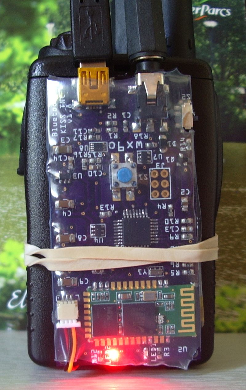
The price was around $49.95 which I thought at the time was amazingly cheap and probably explains why they are all sold out at the time of writing. The module is a small PCB slightly smaller than a Baofeng UV-3R and if you remove the belt clip it can easily be fixed to the back of it. My picture shows it strapped to the back of one of the Baofeng’s predecessors, where it makes a nice inexpensive and compact APRS tracker. The board and it’s battery (which can be charged using a USB cable as shown in the photo) are shrink-wrapped in a tough translucent plastic casing.
Ready-made cables are available. Rob sent me a Kenwood-format two-pin connector which fits the later model Baofengs and the two worked together perfectly. The audio levels were just right on both transmit and receive.
Yes, receive. This is no mere tracker. It’s a full KISS TNC and decoded all the packets received by the Baofeng. The software used was the latest APRSDroid running on my Motorola Milestone (a.k.a. Droid) smartphone. Droid and TNC paired easily and made an effective APRS mobile station.
I did try to pair up the TNC with APRSISCE on an HTC Touch Pro running Windows Mobile 6.1. The two devices paired but could not connect as the Bluetooth software did not recognize the TNC as a valid device type. I think that is a limitation of the Windows Mobile Bluetooth software rather than the TNC module.
If you are interested in APRS and would prefer to do it over the radio rather than a cellular data connection (real hams use RF, right?) then this is a nice toy to play with.


