Posts Tagged ‘SOTA’
 SOTA Rig Reconfiguration
Since I've retired, I've now have the opportunity to have continuous thoughts about things like this without the interference of work or schedule related thoughts, it's great. Consequently, I've had some time to give my rig configuration some thought. What I have done is not totally unique as I have gotten ideas from others and mixed them into my own concoction. I have the 3 Band MTR, with 17m, 20m and 30m. I chose these particular bands so that I would have flexibility on contest weekends. So below is my latest, not my last configuration.
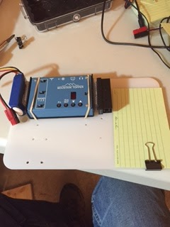
As you can see I am using a backpacking cutting board as the foundation of the setup. I used a product called Scotch Extreme fastener to attache the LIPO battery and the Pico Paddle, it's sort of like Velcro but it snaps into place and is 10x stronger than velcro. I simply drilled holes (this board has seen several iterations as you can see the many holes), and used rubber bands to hold the radio in place. I may decide to use the fastener instead. The "Rite in the Rain" card is for logging. A nice neat package to pull out of the pack, hook up the antenna, plug in the power and off I go.
There are however a couple of further improvements.
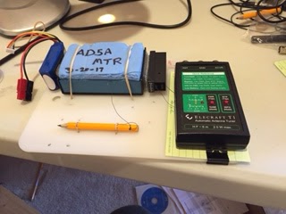
You can see I've added a tethered pencil for logging and an optional Elecraft T1 tuner, if you have a non-resonant wire. I can fasten it to the board with either rubber bands or the Scotch fastener.
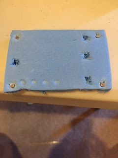
I've also added a protective cover for the MTR. It's made from sleeping pad foam and protects the face and switches on the MTR when getting jostled in your pack. On the backside of the cover I've cut out recesses where the switches are and added little magnets that are attracted to the four screws on the case. Thanks to Fred, KT5X for this idea.
So there you have it, a light, three band, package that is compact, light and ready to go. So until I reconfigure again.
SOTA Rig Reconfiguration
Since I've retired, I've now have the opportunity to have continuous thoughts about things like this without the interference of work or schedule related thoughts, it's great. Consequently, I've had some time to give my rig configuration some thought. What I have done is not totally unique as I have gotten ideas from others and mixed them into my own concoction. I have the 3 Band MTR, with 17m, 20m and 30m. I chose these particular bands so that I would have flexibility on contest weekends. So below is my latest, not my last configuration.
As you can see I am using a backpacking cutting board as the foundation of the setup. I used a product called Scotch Extreme fastener to attache the LIPO battery and the Pico Paddle, it's sort of like Velcro but it snaps into place and is 10x stronger than velcro. I simply drilled holes (this board has seen several iterations as you can see the many holes), and used rubber bands to hold the radio in place. I may decide to use the fastener instead. The "Rite in the Rain" card is for logging. A nice neat package to pull out of the pack, hook up the antenna, plug in the power and off I go.
There are however a couple of further improvements.
You can see I've added a tethered pencil for logging and an optional Elecraft T1 tuner, if you have a non-resonant wire. I can fasten it to the board with either rubber bands or the Scotch fastener.
I've also added a protective cover for the MTR. It's made from sleeping pad foam and protects the face and switches on the MTR when getting jostled in your pack. On the backside of the cover I've cut out recesses where the switches are and added little magnets that are attracted to the four screws on the case. Thanks to Fred, KT5X for this idea.
So there you have it, a light, three band, package that is compact, light and ready to go. So until I reconfigure again.
2016 SOTA Activity Days
 Summits On The Air (SOTA) operating events are a great way to promote activity and create opportunities for summit-to-summit radio contacts. Here’s the 2016 calendar, an update of the 2015 list suggested by Guy N7UN. Many of these dates are aligned with VHF events but there will be HF activity as well.
- Jan 30-Feb 1: ARRL Jan VHF Contest + NA SOTA Winter Activity Weekend
- Apr 16-17: North America SOTA Spring Activity Weekend
- Jun 11-13: ARRL June VHF Contest + NA SOTA Summer Activity Weekend
- Jul 16-17: CQ WW VHF Contest + optional for SOTA
- Aug 6-7: Colorado 14er Event + NA SOTA Rocky Mtn Rendezvous + W7 SOTA Activity Weekend + ARRL UHF Contest
- Sept 10-12: ARRL Sept VHF Contest + NA SOTA Fall Activity Weekend
 Of course, any day is a good day for SOTA activity. The August 6-7 weekend looks to be the alignment of the planets with four events happening around that weekend. Early August usually offers excellent conditions for hiking the highest peaks in Colorado, so come on out and play.
For more info on VHF SOTA, see How To Do a VHF SOTA Activation.
Get off the couch, put on your hiking boots, grab your backpack, grab your radio but most important: get on the air!
73, Bob K0NR
The post 2016 SOTA Activity Days appeared first on The KØNR Radio Site.
The Most Radio-Active Mountain in Colorado
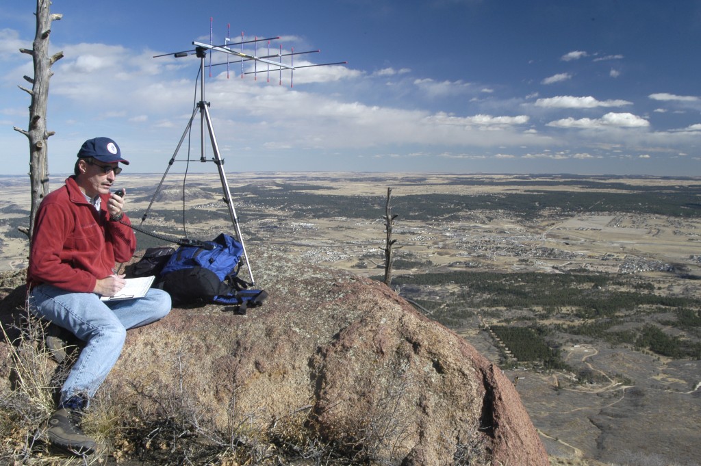
K0NR Operating VHF on Mt Herman (Photo: Ken Wyatt WA6TTY)
I’ve often said that Mount Herman (W0C/FR-063) is the most (ham) radio active mountain in Colorado. Many of us have operated from that summit for VHF contests, QRP events and Summits On The Air (SOTA). Of course, I didn’t have any data to back that claim…until now. A review of the cumulative SOTA activations in Colorado through Jan 1, 2016 shows these four summits as the most-activated SOTA peaks.
| Summit | SOTA Designator | Number of Activations |
| Mount Herman | W0C/FR-063 | 95 |
| Pikes Peak | W0C/FR-004 | 53 |
| Mount Evans | W0C/FR-003 | 33 |
| Squaw Mountain | W0C/PR-082 | 31 |
All of these summits are relatively close to the large population centers in the state. Also, they not that difficult to get to and some of them have roads that go to the top. Pikes and Evans are both 14ers but can be accessed via 2WD vehicles.
But what makes Mount Herman so special? It does not have a road to the summit — you definitely have to hike it, a little bit more than a mile one way with elevation gain of ~1000 feet. What makes the difference for Herman is that it is in the backyard of the well-known radio ham, goat hiker and SOTA enthusiast, Steve WGØAT. Steve has personally activated the summit more than 30 times AND he drags along mentors encourages other radio hams to join him. Frank KØJQZ did 22 activations, some with Steve and many on his own. (Frank just achieved SOTA Mountain Goat status, activating enough summits to earn 1000 SOTA points.) Fortunately for me, Mt Herman is about 4 miles as the GPS flies from my house, so I have worked that summit 31 times (usually Steve or Frank and always on 2 meters). I’ve also activated Mt Herman for SOTA three times, as described here: A Soggy Mount Herman SOTA Activation, Mt Herman: SOTA plus VHF Contest and Winter Assault on Mt Herman.
Here’s one of Steve’s fun videos that captures the first SOTA activation of Mt Herman, with his goat crew Peanut and Rooster (SK).
Frank and Steve, thanks for all of the Q’s from Mt Herman over the past years! See you on the air and on the trail.
73, Bob KØNR
The post The Most Radio-Active Mountain in Colorado appeared first on The KØNR Radio Site.
Winter Assault on Mt Herman (W0C/FR-063)
On the last day of the year, it seemed like a good idea to get in one more SOTA activation. It turns out that I had not been up Mt Herman (W0C/FR-063) all year, even though it’s close by. See this page for the trail description. Joyce KØJJW and I decided to hike up in the morning, reaching the summit around 11 AM local time. This was my third SOTA activation of Mt Herman, but I’ve operated from there many more times in various VHF contests (back before SOTA was a thing in Colorado).
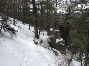
Winter conditions on Mount Herman trail.
The road to the trailhead was in good condition but snowpacked and icy. This road is not plowed during the winter but it is often passable with a decent 4WD vehicle. Today, you could make it to the trailhead with 2WD and some careful driving. The trail conditions were typical for winter time: almost completely covered in snow with a few bare spots showing here and there. The trail was packed powder and not particularly icy. Still, we appreciated having traction devices on our boots. This trail can be downright treacherous when it ices up, so traction devices (Yaktrax, Microspikes, etc.) are highly recommended. Trekking poles can be helpful, too.
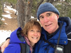
Joyce K0JJW and Bob K0NR on the trail.
Once at the summit, I used my Yaesu FT-60 handheld radio and a half-wave vertical antenna to work people on 146.52 MHz. Having notified a number of people that I would be on the air, I actually had a bit of a pile up on 2m fm. In short order, I worked KE5QNG, WA6MM, KH7AL, WG0AT, W7AWH, K9MAP, K0JQZ, K9DBX, W0STU, KD0MFO, WB0ROK, KD0VHD and KL7IZW. Best DX was about 50 miles with W7AWH in Pueblo West. Thanks to everyone that got on the air to work me.
The weather was cold, about 15 deg F, so we didn’t stay too long on the summit and headed back down the trail. OK, maybe “winter assault” is a bit of an exaggeration. Let’s call it a fun hike in cold weather.
73, Bob K0NR
Other postings on SOTA activation of Mt Herman:
Soggy Mount Herman SOTA Activation (W0C/FR-063)
Mt Herman: SOTA plus VHF Contest
The post Winter Assault on Mt Herman (W0C/FR-063) appeared first on The KØNR Radio Site.
Just Another VHF SOTA Contact
On Sunday, I noticed that Brad WA6MM posted that he planned to activate Dakota Hill (W0C/SR-051) for Summits On The Air (SOTA). Dakota is not a good VHF shot from my house but I was planning to be mobile out east towards Black Forest that morning, so it was worth a try. I texted Brad to let him know I’d be looking for him on 2m fm.
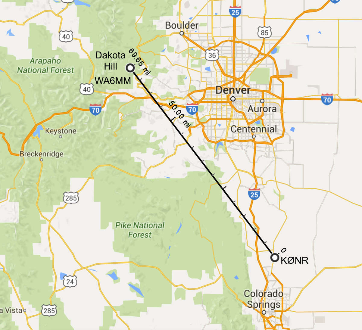 Heading south on Highway 83, the road was gaining elevation when Brad let me know he would soon be on the air. Dakota Hill is 10,929 feet and set back into the mountains, so I wasn’t sure if I could make the RF trip over Palmer Divide to work him. I pulled over at the crest of the hill and made a call. Brad had moved off 146.52 MHz due to some intermod interference and was on 146.55 MHz. Brad was using his trusty handheld radio running 5 watts into a half-wave antenna while I had a 50 watt mobile with a 1/4-wave antenna on the roof of the SUV. We made the contact without too much trouble…his signal was half scale on the meter. I listened to Brad work another station as I drove on, losing elevation and losing Brad’s signal on the other side of the hill. That was apparently THE SPOT to make the contact.
I put WA6MM into the log, scoring 6 SOTA chaser points for the 70 mile QSO. No, this wasn’t a rare DX station, no new record set, nothing that exceptional to report, actually. But it was a fun contact, with Brad hiking to a summit in December and me trying to find a location to work him.
This is why I like VHF on SOTA. Just another example of having fun messing around with radios.
73, Bob K0NR
The post Just Another VHF SOTA Contact appeared first on The KØNR Radio Site.
Recent Activations Out West
California
I was in Northern California, of all tough places to be, Napa. While having a look at the nearby summits I discovered that all the nearby summits were 1 or 2 pointers. Should be easy right. Well not so much. One of the inequities of SOTA, albeit well understood, is that elevation is the major determinant of point value, not length of climb or difficulty. Although all of that tends to even out over time if you do enough summits. I used my MTR II configured for 17M, 20M and 30M. I brought my LNR Trail friendly 40/20m antenna and a T1 Elecraft Tuner. The tuner failed, so I could only operate on 20m exclusively.
Mt. Diablo
 |
| View from Scott Hill |
 |
| Scott Hill in the Distance |
Quarry Mountain
This summit, W7U/NU-067, is not the most scenic and the trail winds through a lot of scrub brush. There is a little more cover on top and so some shade to set up the station. It is a 2 mile round trip and is a 6 pointer. It was my second activation on a day that netted 14 points. Below is a short video from the summit.


