Posts Tagged ‘Mountains’
 SOTA Activation: W0C/SP-089 Unnamed Summit
With the summer season definitely here, Joyce (K0JJW) and I climbed W0C/SP-089, an unnamed summit east of Buena Vista near Trout Creek Pass, for a Summits On The Air activation. This summit is also referred to by its elevation: 10525. The mountain is quite majestic with a large rock face that rock climbers enjoy climbing.
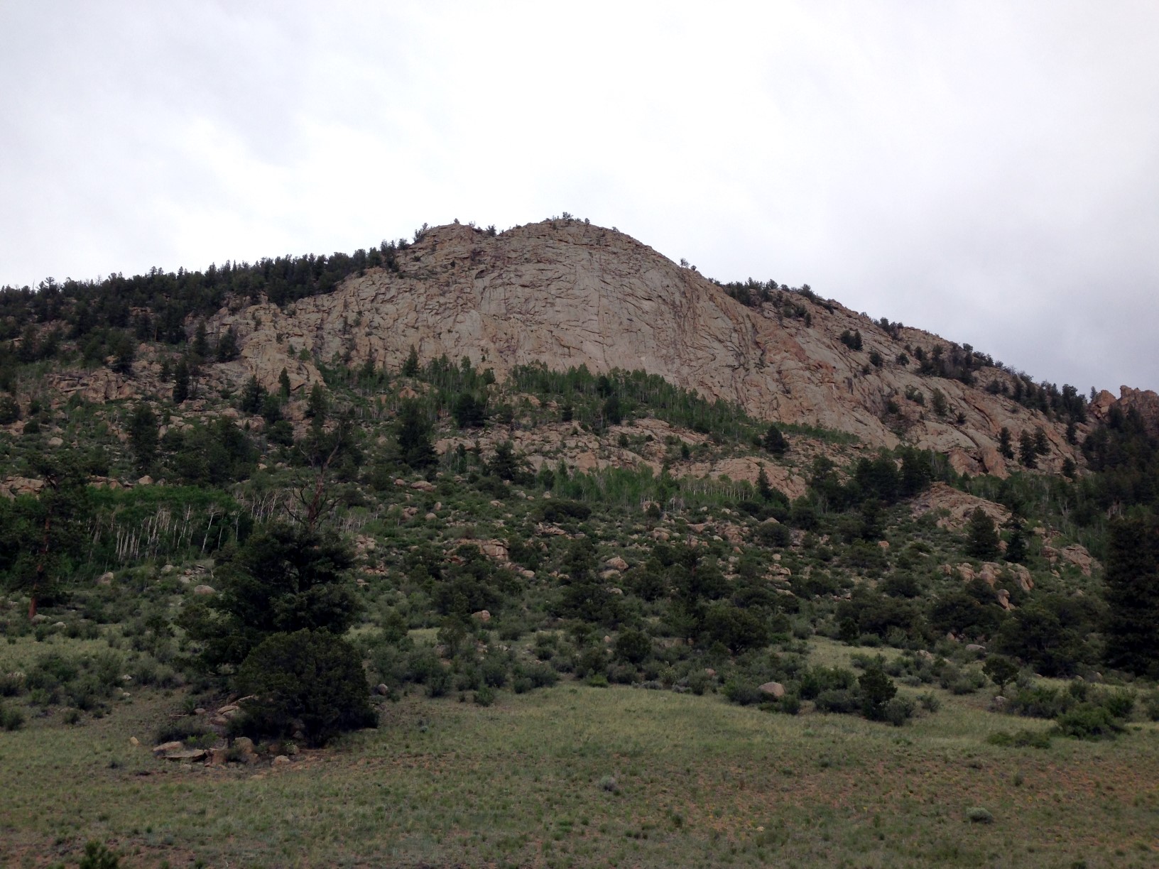
View of W0C/SP-089
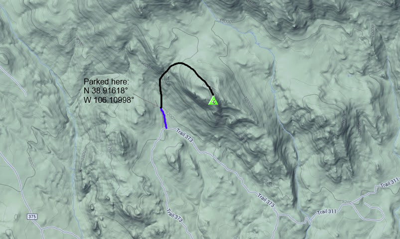
To reach the summit, we drove a 4WD truck from Trout Creek Pass on Forest Service Road 311, connecting to FS Road 373. Four wheel drive is required for this road due to the steep sections, which may not be passable in muddy conditions. You can also approach from the Buena Vista side, see the San Isabel Forest Service Map. From 373 we took a side road (shown in blue on the map below) that is not always shown on maps. I believe it is marked 373A but I am not sure. We parked the truck at the lat/lon shown.
From there we hiked a non-technical route to the west of the summit, working our way up through the draw shown on the map. There were a few faint game trails here and there but mostly it was some challenging bushwhacking up that draw. The willows and sticker bushes made us glad that we had long pants on. Also, there was quite a bit of downed timber to step over. The route got quite a bit easier once we got to the top of the draw, but still no trail. The elevation gain was only 1100 feet but it felt like a lot more work than that.
 As we neared the summit, I heard Bob (W0BV) calling me on 146.52 MHz. I had put out an email alert to some of the hams in the area so Bob and some others knew I was going to be out climbing. Once I got to the summit, I contacted Bob (W0BV) and quickly had a mini-pileup with several stations calling me. Mark (KF5WCY) visiting from TX gave me a call, followed by Carl (K5UK) near Mount Yale. Then I worked Jim (KD0MRC) in Buena Vista and Larry (KL7GLK) in Leadville. Thanks, guys, for getting on the air and contacting me!
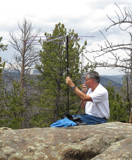
I used my Yaesu FT-60 handheld transceiver and a 1/2-wave vertical antenna for these contacts. While I had my 3-element Yagi antenna with me, I did not bother to set it up.
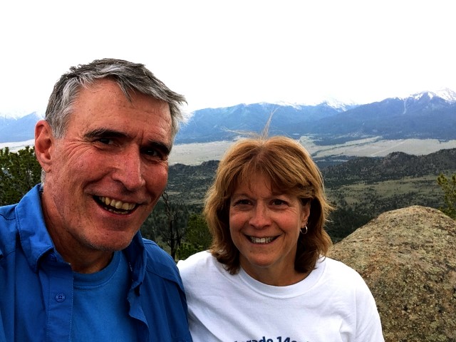
Bob (K0NR) and Joyce (K0JJW) on the summit
My spouse and hiking companion Joyce (K0JJW) and I have worked out a standard SOTA activating procedure. As we get close to the summit, she stops below the activation zone and I continue to the top. Then I work her on 146.52 MHz which guarantees a successful activation. It is possible to get skunked on 2m fm in the backcountry, so this is good insurance. This one QSO does not result in any SOTA points, since the rules require a minimum of four contacts for activation points. Next, Joyce joins me on the summit and we work whoever is out there. Lately, I’ve had pretty good luck getting at least 4 contacts on 2m fm. On the descent, she stays on the summit and I go down the mountain and work her once I am outside of the activation zone. That way, I am able to work the summit, too. Then she leaves the summit, catches up with me and we descend the rest of the way together.
For more information on VHF SOTA activations, see How To Do a VHF SOTA Activation.
73, Bob K0NR
SSB Makes the Difference on Prospect Mountain
Spring is finally making an appearance in the Rocky Mountain region which means it is time to get on top of some SOTA peaks and transmit some RF energy. On Saturday, Joyce K0JJW and I had planned to drive through the Big Thompson Canyon to Estes Park and also sneak in a quick SOTA activation. Matt K0MOS suggested a few peaks and we chose Prospect Mountain (W0C/FR-069) just south of Estes Park. See Matt’s trip report for a good overview of the hike.
For a low hassle SOTA activation, I usually just take my Yaesu FT-60 handheld radio and operate 2m FM. Most of the VHF activity is on FM anyway and I usually rustle up some SOTA contacts that way. On this trip, I also brought along my Yaesu FT-817 so that I could operate 2m ssb, to provide better weak signal options. For SSB operation, my 3-element Arrow yagi antenna was mounted on my walking stick for easier pointing, with horizontal polarization.
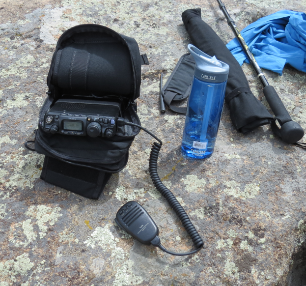 The above photo shows the FT-817 in its Sitting-On-A-Big-Rock operating position, using the AMP-3 carrying case with lead-acid battery inside.
I had arranged a sked with Stu W0STU who was located ~100 miles away with a group of Scouts at Peaceful Valley Scout Ranch. There wasn’t a solid radio path between our two locations, so I wasn’t sure if we’d make it or not. I did not think we could make the contact on FM but the efficiency of SSB should do better. He had a small yagi pointed in my direction driven by an FT-857 transceiver but we tried working on 144.200 MHz SSB without any success. Another station W6LEV near Loveland came up on the calling frequency so I worked him.
After working a few stations on 146.52 MHz using a half-wave whip on the FT-60, I decided to try to work W0STU one more time. I sent him a text message and confirmed that he was available. However, snow was moving into his location (welcome to spring) so he had dismantled his yagi antenna and only had a vertical antenna on his truck. I told him to give me a call on 144.200 SSB and I’d try to find him. I flipped my yagi to vertical polarization and pointed in his direction.
At first, I heard nothing but noise. I was about to give up when I rotated my antenna around to see if the signal peaked up in another direction. Sure enough, when pointed S/SW, I could hear Stu’s signal rise to just above my noise floor. His actual direction from me was SE, so we were probably getting a reflection off one of the mountains to the south. My signal was right at his noise floor, so we just barely completed a contact. Without the weak-signal performance of SSB and the gain of the yagi antenna, I am sure we would have never completed the contact. Another lesson is that it pays to point your antenna in different directions, since you don’t always know what the best propagation path will be.
Another fun day messing around with ham radio.
73, Bob K0NR
Colorado 14er Event – August 3, 2014
![]() During the Colorado 14er Event, Amateur Radio operators will be climbing many of Colorado’s 14,000-foot mountains and SOTA summits to set up amateur radio stations to communicate with other radio amateurs across the state and around the world. Join in on the fun on Sunday August 3 and see how many of the mountaintop stations you can contact.
During the Colorado 14er Event, Amateur Radio operators will be climbing many of Colorado’s 14,000-foot mountains and SOTA summits to set up amateur radio stations to communicate with other radio amateurs across the state and around the world. Join in on the fun on Sunday August 3 and see how many of the mountaintop stations you can contact.
The new Colorado 14er Event logo is now available on t-shirts and more.
Starting in 2012, Summits on The Air (SOTA) is part of this event. This means there are over 1700 summits that you can activate in Colorado, with a wide variety of hiking difficulty. This opens up the event to a lot more people and a lot more summits. See the new SOTA page.
Radio operators with 14er climbing experience who plan to activate a summit should log their name and intended peak at the Ham14er Yahoo group. This is also the email list for discussing the event and asking questions.
Farewell, Rooster
Many of you have gotten to know Rooster and Peanut, through the videos by Steve WG0AT, the Alpha Goat. Some of you have been fortunate enough to meet the goats in person, which is always a real treat. I blogged about Steve and his goats a number of times, see this posting that highlights one of Steve’s videos.
Today we received the sad news that Rooster has died, a Silent Key in ham radio jargon.
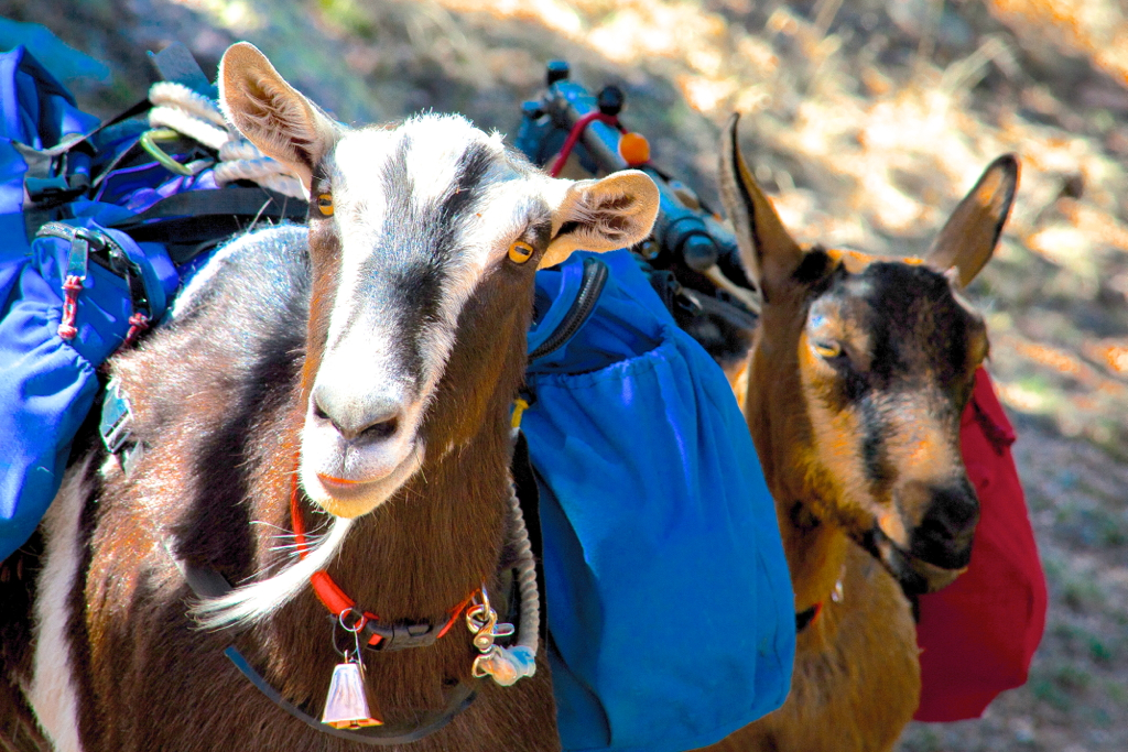
Rooster and Peanut, the most famous SOTA Goats in the entire world
Steve sent this message:
It’s with deep sorrow I have to make this announcement …”Rooster” goat died suddenly last night of unknown causes …his trail buddies will soon be scattering Rooster’s ashes on many SOTA peaks throughout western NA
73, Bob K0NR
A Great Bag for the FT-817
One of my favorite rigs is the Yaesu FT-817, the QRP transceiver that covers HF through 70 cm. I use it for mountaintop VHF, including Summits On The Air (SOTA) activations.
At Pacificon, I came across this bag by AMP-3 which is custom designed for the FT-817. David KF7ETX did a great job designing this bag, which he explains in this video.
There are cheaper solutions out there but this is the best one I’ve seen.
73, Bob K0NR
A Classic SOTA Hike: Midland Hill (W0/SP-117)
Today, Joyce K0JJW and I decided to hike Midland Hill (W0/SP-117) near Buena Vista, CO (otherwise known as “BV”) and do a SOTA activation on VHF. I call this a “classic SOTA hike” because it is a real hike that requires some exertion, a well-maintained trail to the summit and some great views at the top. By my GPS, it was 2.4 miles one way, with 1600 feet elevation gain.
This hike starts at the trailhead on the east side of BV, where a footbridge crosses the Arkansas River. The SummitPost trail description is very helpful, so be sure to check it out. I checked quite a few topo maps of the area and most of them do not show the trails accurately. I found them more confusing that helpful. I’ve included my GPS track on the map below.
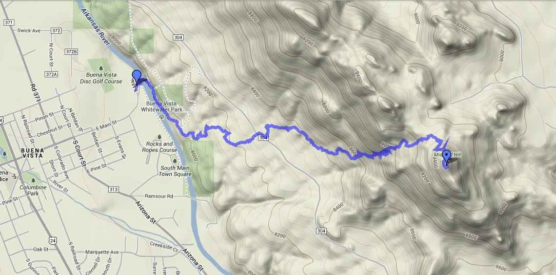
GPS track for Midland Hill
We started at the trailhead, immediately crossing the footbridge to the east side of the river. Then we followed the Midland Bike Trail which parallels the river. Very soon after the bridge, there is a trail leading off to the left (east) uphill that is tempting but we stayed on the main trail that parallels the river. At about 0.5 miles in, we crossed County Road 304 (38.843508 deg N, 106.112297 deg W) onto the clearly marked 6032 trail, which goes up to Midland Hill. Just follow the trail and do not turn onto 6032A trail as it goes off to the left.
If you are pressed for time, you can start the hike where 6032 intersects CR 304, but that only saves 0.5 miles. You’ll miss the bridge and great views of the Arkansas River.
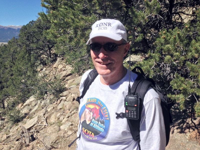
Bob K0NR on the trail
Once we reached the summit, I set up on 146.52 MHz using my VX-8G connected to the 2M Arrow Yagi. Joyce stayed back outside of the activation zone, so I worked her as soon as I made the summit. Then Walt WZ0N came up on frequency and gave me a second contact. I contacted a couple of mobile stations: Ryan KD7OHA on Highway 50 near Texas Creek and Bud NP2CT on Highway 285. Other contacts where with some of the local hams: N0OFQ near Nathrop, Jerry N0VXE and Skip W9GYA near Salida. Not bad for a Monday afternoon in the mountains. Thanks, guys, for the contacts!
Lately, some of the SOTA hikes I’ve done have involved bushwacking up the side of a steep hill to get to the summit. It was great to have a real trail this time. The 1600 vertical feet did get me huffing and puffing but that’s part of the experience. I highly recommend this summit!
73, Bob K0NR
How To Do a SOTA Activation On Pikes Peak
This post was updated on June 4, 2022, after the summit house construction was completed.
Perhaps this should be called The Slacker’s Guide to Activating Pikes Peak since I am going to describe the easy way to do a Summits On The Air (SOTA) activation on America’s Mountain. If you plan to hike up, you have my complete support but this post is not meant for you.

Pikes Peak (W0C/FR-004) is about 10 miles straight west of downtown Colorado Springs. See the Pikes Peak website for useful tourist information. At an elevation of 14,115 feet, the mountain towers over Colorado Springs and the other front-range cities. (You may see the elevation listed as 14,110 but it was revised upward in 2002 by the USGS.) This means that it has an excellent radio horizon to large populated areas. On VHF, it is possible to work stations in Kansas, Nebraska, Wyoming and New Mexico. See VHF Distance From Pikes Peak and Pikes Peak to Mt Sneffels. On HF, you’ll do even better.

Getting There
Access to the summit has three options: hike up, drive up via the Pikes Peak Highway or ride the Pikes Peak Cog Railway. Most people will probably choose the highway since the cog rail only gives you 30 to 40 minutes on the summit. (Normally, you return on the same train that takes you to the top. You can try to schedule two one-way trips but that is a challenge.)
After a few years of turmoil and construction, the summit of Pikes Peak is now back to operating normally but with some changes. The new summit house/visitors center is open and it is a beautiful new facility. The Cog Railway is also operational with brand new equipment. There is a new boardwalk that allows easy strolling on the summit and improved views near the edge of the summit.
Pikes Peak Highway
The highway is at a well-marked exit off Highway 24, west of Colorado Springs. There is a “toll” to use the highway (~$15 per person, check the Pikes Peak Highway website for the latest information and a $2 discount coupon.) Starting in 2022, you must have a reservation (2-hour window) to drive to the summit (roughly Memorial Day to Labor Day). The specifics are likely to change, so be sure to check the Drive Pikes Peak page for the latest updates.
The road is paved all of the way to the top and is usually in good shape. The only caution on driving up is that some people get freaked out by sections of the road that have steep drop-offs without guard rails. It is very safe, but some folks can’t handle it. The main caution driving down is to use low gear and stay off your brakes. There are plenty of signs reminding you to do this and during the summer there is a brake check station at Glen Cove where the rangers check the temperature of your brakes.
It takes about an hour to drive to the summit, assuming you don’t dawdle. It is best to drive up during the morning and avoid the afternoon thunderstorms.
On The Summit
The W0C Association Reference Manual (the SOTA rules for Colorado) used to suggest a “qualifying hike” of 100 vertical feet but this item has been removed from the manual. If you decide to do such a hike, I suggest you proceed down Barr Trail which is the main hiking trail coming up from the east side of the peak. Do not try to walk along the road, as the rangers will stop you. The trail starts on the east side of the summit house (towards Colorado Springs) and is marked with a sign. You have to cross over the cog rail tracks to get to it. (Please try to avoid getting run over by the train as it scares the tourists and makes a mess.)
The summit of Pikes is broad, flat and rocky, so pick out a spot away from the buildings for your SOTA adventure. There are quite a few radio transmitters on the peak so expect some interference. Since this is way above treeline, your antennas will have to be self-supporting. For VHF, giving a call on 146.52 MHz FM will usually get you a few contacts and sometimes a bit of a pileup. Be aware that on top of Pikes you are hearing everyone but they can’t always hear each other. It can get confusing. Another VHF simplex frequency worth trying is 146.58 MHz (The North America Adventure Frequency). On the HF bands, pray for good ionospheric conditions and do your normal SOTA thing.
Your body and your brain will likely be moving a little slower at 14,000 feet due to the lack of oxygen. Don’t be surprised if you have trouble deciphering and logging callsigns. Take it slow and monitor your physical condition on the peak.
Bring warm, layered clothes, even in the summer, since Pikes Peak can have arctic conditions any time of the year. Keep a close eye on the weather since thunderstorms are quite common during the summer months. Lightning is a very real danger, so abandon the peak before the storms arrive.
73, Bob K0NR
Resources
SOTAwatch web site
W0C SOTA Website
Pikes Peak Tourist Information
Pikes Peak (W0C/FR-004) SOTA Page
Pikes Peak Webcams
The post How To Do a SOTA Activation On Pikes Peak appeared first on The KØNR Radio Site.


