Archive for the ‘dx’ Category
 What was your first major receiver?
 May 30th, 2026 |
  Author:
 I started in the ham radio and shortwave listening hobby in 1972. By 1975, this was my first real receiver. It heard very well, and ignited my lifelong passion for radio.

The R-366/TRR-5 military receiver.
This old radio, the R-366/TRR-5, which is clearly identified on the faceplate in this picture of the military rig, had great ears. It was what I used to hone my Morse code copying skills and to get the hang of how amateur radio operators conducted communications with each other, with CW, AM, or SSB. I hope someday to own one once again.
The R-366
The R-366/TRR-5 is a significant piece of military history manufactured for the Navy Department Bureau of Ships by the Espey Manufacturing Company. Built during an era when the United States Navy required absolute reliability for ship to shore and ship to ship communications, the unit is a testament to the rugged industrial design of the mid-twentieth century. Often referred to as part of the TRR-5 receiving set, this equipment frequently incorporated high quality components and precision engineering including the gold standard Collins Radio Company designs of that period. These internal components were vital in providing the remarkable stability and selectivity needed to pull weak signals out of the dense electronic noise environment found on a crowded naval vessel. It did have heterodyne squeals on a select few frequencies, which any old tube receiver was prone to have, but those did not detract from the excellent capability of the radio.
The Service
For the sailors and radio operators serving aboard ships in the 1950s and 1960s these receivers were far more than just tools for duty. In the often cramped and isolated conditions of life at sea these radios served as a critical psychological anchor. Access to the bands meant hearing the familiar sounds of home or tuning into MARS stations where amateur radio operators facilitated phone patches that reconnected sailors with their families. This bridge to the outside world was essential for maintaining morale and supporting the mental health of military personnel who were otherwise cut off from the rhythms of civilian life for months at a time. Sitting in the radio shack and slowly tuning that large central dial while listening to the crackle of the ionosphere was a meditative escape from the constant hum of shipboard operations. Many ships would pipe ball games and news shows, or music programs, over the ships intercomms, providing health and morale to the personnel.
Operating the Radio
The tactile experience of operating this specific receiver remains vivid in my memory. The layout with its distinct knobs for selectivity phasing and BFO control was designed for the hands of a professional radio operator who needed to manipulate the signal in real time. It required a disciplined ear and a steady hand to copy Morse code through heavy atmospheric conditions but that struggle made every successful reception feel deeply rewarding. It taught me the patience and technical appreciation that have defined my amateur radio hobby for decades. Owning and using a piece of history like this represented a connection to the generations of operators who stood the watch before me.
Traveling the World…
With this historic military receiver, I discovered an entire world as a child in the mid 1970s. I spent countless nights in the quiet darkness of my room with only the warm orange and yellow glow from the vacuum tubes leaking out of the back and top grills and slots of the radio enclosure, as those hot tubes cast soft light on the ceiling and walls. That radio allowed me to travel the globe from my listening position often sitting cross-legged on the floor in front of this big rig. Those late night listening sessions, when I should have been sleeping, ignited a lifelong passion for understanding the vast and interconnected world of shortwave radio as well as medium-wave DXing. I heard International Shortwave Broadcast stations as well as AM broadcast stations from Europe, Asia, the South Pacific, the Atlantic regions, South America, Central America, and North America–all over the world! I listened to amateur radio operators on Morse code, SSB, and AM modes. Ships at sea, aircraft doing transoceanic flights, fishing vessels comms where fishing captains would chat with other boat captains, and even military communications were all at my fingertips on the dial of the radio as I listened to these exotic places by headphones. I even picked up a station from Peru, South America late one night, on the mediumwave broadcast band. That is how great that receiver could hear. Of course, I had a very excellent outdoor dipole antenna that was cut for 160 meters.
What Receiver Was Your First?
What was your first major receiver? Was it just a receiver, or was it a transceiver? When was that? What did you hear that captured your imagination? Do you still have that radio?
I hope to someday have this R-366/TRR-5, once again.
~ Happy DX!
NW7US
Powerhouse History: WLW, W8XAL, WSAI
The photograph, below, captures a compelling moment of technical mastery during the formative years of American broadcasting, set deep within the inner workings of the Crosley Radio operation in Cincinnati, Ohio, during the 1930s. This was not just a studio but a nerve center for one of the most ambitious radio experiments in history. In the frame, an unidentified announcer sits with a quiet, practiced focus before a sensitive microphone, his presence framed by a formidable wall of equipment that served as the control interface for Powel Crosley Jr.’s broadcasting empire.

WLW, W8XAL, and WSAI
The machinery in front of him represents the sophisticated control panels for three distinct stations, labeled for WLW, W8XAL, and WSAI. These panels were the operational gateway to a signal that redefined the reach of radio. WLW, in particular, earned the nickname The Nation’s Station, and for a brief but legendary period in the mid-1930s, it was granted special authorization by the Federal Communications Commission to experiment with a massive power output of 500,000 watts. This made it the most powerful radio station in the United States, a true technological titan of the era. The signal was so incredibly potent that listeners across North America and beyond often reported hearing the broadcast under unusual circumstances, such as through the metal teeth of fillings, in the coils of mattress springs, or even through the humming of household plumbing.
Beyond the standard AM broadcast of WLW, the inclusion of W8XAL in this control room highlights the critical role shortwave technology played in the Crosley vision. While the standard AM signal was meant for domestic reach, W8XAL served as an experimental shortwave companion, designed to project the Cincinnati broadcasts far beyond the limitations of local and regional airwaves. Shortwave radio waves possess the unique ability to bounce off the ionosphere, allowing signals to travel thousands of miles and transcend national borders. Through W8XAL, the Crosley organization was testing the feasibility of true international broadcasting, turning the modest studios in Cincinnati into a point of origin for listeners located as far away as South America or Europe.
This shortwave capability was a significant leap in the evolution of mass media. It represented a deliberate attempt to overcome the geographical isolation that had defined the earlier, more fragmented era of radio. By operating on shortwave frequencies, the announcers and engineers were participating in a grand experiment to see if a single localized voice could truly become a global one. It was an ambitious pursuit that demanded even greater precision than standard broadcasting, as atmospheric conditions and solar activity could frequently disrupt the long-distance transmission path.
Working in this control room was a task that required both the poise of a performer and the precision of an engineer. Each dial, needle gauge, and switch was a critical element in maintaining the integrity of the broadcast, as the announcer had to carefully monitor the modulation levels to ensure the signal remained clear and stable for millions of listeners. A lapse in focus could mean a technical failure or a broadcast error that reached a massive, dispersed audience in real time. It was a high-stakes, high-pressure environment, yet it functioned as the primary, and often only, window to the wider world for families weathering the depths of the Great Depression.
Powel Crosley Jr. was a man of intense vision, and he understood better than most that radio was the ultimate tool for domestic and international unification. These transmitters were the engine that bridged the vast geographical distance between his studio in Cincinnati and the living rooms of families scattered across the continent and beyond. When people turned their dials to find the station, they were connecting to a piece of engineering that stood at the very cutting edge of the twentieth century. Looking at this image today, it is easy to feel a sense of awe for that era, when the simple act of turning a knob could bring the world into a home, effectively shrinking the vastness of the country and changing the way society experienced culture, news, and shared humanity forever.
1946: Thousands of Hams Allowed Back on the Air
I have been spending time reflecting on the history of our wonderful hobby, and this April 1946 issue of Radio News really grabbed my attention. It is such a fascinating time capsule because it highlights the exact moment when thousands of hams were finally allowed back on the air after the long, forced silence of World War II. During the war, the United States government issued a total moratorium on all amateur radio activity, fearing that transmissions could be used by enemy agents to relay information. For four and a half years, our equipment sat idle and our antennas were taken down.

Radio News, April 1946, Cover
This is Bill Shaw, W9UIG, in this photo. He was among the first back on the air, and his station setup was really something else for the time. He was running a capable 500-watt station with a 3-element beam antenna, which was quite a powerhouse back then. His receiver was the legendary Hammarlund HQ 120X, which was a dream for many operators, and it was prized for its stability and sensitivity. Because early receivers often struggled with noise and image rejection, he used an RME DB20 preselector. This unit sat between his antenna and the receiver to provide additional gain and help pull weak signals out of the background noise. He also used a Meissner Signal Shifter, which was essentially a variable frequency exciter that allowed him to shift his frequency to find an empty spot or avoid interference, rather than being stuck on one fixed crystal frequency.
I look at those glowing vacuum tubes in his equipment, and those on display on his desk, and it reminds me of why I love this craft so much… there is just something special about the warmth and the technical artistry of those older rigs, with all their high voltage requirements and intense heat. And of course, I could not help but notice the wall behind him absolutely covered in QSL cards from all over the world. That really is the heart of why we do this, is it not… that thrill of reaching out across the globe and collecting those cards as a badge of honor? He had cards from places like Australia, the United Kingdom, and New Zealand, which shows he was an active DXer who specialized in long distance communication. In 1946, there was no internet or satellite communication, so amateur radio was truly the only way for a private citizen to speak directly to someone on the other side of the planet. It really makes you appreciate the history behind the call signs we use today. Does anyone else get nostalgic looking at these old shack photos… I would love to hear your thoughts on these classic setups and the history of our craft!
Regarding the magazine: While the magazine, Radio News, had its roots as, Radio Amateur News, when Hugo Gernsback founded it in 1919, it quickly evolved into something much broader as the radio industry itself exploded. By the 1940s, Radio News was far more than just a ham radio publication, it was a comprehensive technology magazine that covered the entire spectrum of radio and emerging electronics.
During that era, these magazines played an absolutely massive role in the amateur radio hobby. They were essentially the internet, the local club meeting, and the technical manual all rolled into one. For the average ham, a monthly arrival of Radio News or its contemporaries like QST or CQ Amateur Radio Magazine, was an essential lifeline. Side note: I wrote the propagation column in CQ Amateur Radio Magazine (and in CQ VHF, Popular Communications Magazine, Monitoring Times, and The Spectrum Monitor). For CQ, I wrote every month from 2001 to its demise at the passing of its publisher, Dick Ross, K2MGA (sk).
These magazines provided the blueprints and technical schematics that allowed hams to build their own transmitters and receivers from scratch. Because commercial gear was expensive and often hard to come by, the homebrew culture was the backbone of the hobby. Magazines provided the detailed instructions for these projects, teaching a generation of radio enthusiasts how to solder, how to wind coils, and how to understand the complex circuitry of vacuum tubes.
Beyond the technical side, these magazines served as a vital community connector. In a time when the hobby was geographically isolated, they fostered a sense of belonging to an international fraternity. They published operating news, shared tips on DXing (long-distance communication), and established the behavioral expectations and operating standards that defined what it meant to be a true amateur. They taught us how to be gentlemanly, how to handle interference, and how to take pride in our operating technique.
For a young operator in the 1940s, these magazines were the doorway to the world. They documented the rapid technological shifts happening at the time, such as the transition from crystal control to VFOs, the introduction of television, and the post-war availability of surplus military equipment. They did not just tell you how to operate; they inspired you to learn more, to push your technical boundaries, and to see your shack as a part of a global, scientific endeavor. It is that spirit of constant learning and curiosity that kept us all coming back to our keys and microphones, decade after decade.
What other vintage radio publications do you remember fondly from those early days in the hobby?
CQ Worked All Zones
I always have an operating goal in sight to motivate me to get on the air. On the HF bands, I followed the typical progression of getting Worked All States (WAS), Worked All Continents (WAC), and DX Century Club (DXCC). It seems that DXCC receives all the glory and attention, with many DXers pursuing the goals of working all countries, I mean entities.
Worked All Zones
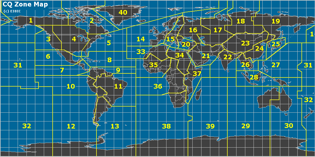
 The Worked All Zones (WAZ) award is another well-known HF DX award, organized by geography. WAZ recognizes operators for establishing confirmed two-way radio contacts with stations in all 40 geographic zones defined by CQ’s official zone map. These zones divide the world into areas based on continents, regions, and specific entities (see the map below).
 This zone-based structure emphasizes propagation challenges and global coverage, often making certain zones (e.g., remote Asian or polar areas) particularly difficult depending on the operator’s location. If the goal is to recognize “working the world,” this approach seems much more logical to me than the DXCC award. For DXCC, the initial award is for 100 countries/entities, which may or may not be spread worldwide. DXCC recognizes political boundaries, which result in many different entities clustered in small geographic areas. For example, the Caribbean is filled with many small countries that are easily accessible from the US. Europe is also dense with countries. The WAZ award requires you to work stations all over the world.
My Journey
I had not paid too much attention to working all zones until recently. I began tracking them and making a point to chase the ones I needed. Of course, working DX already produced contacts with many zones around the world. I have a mixture of SSB, CW, and digital (FT8) contacts, so I was focused on the Mixed award. My HF station is modest, running 100 watts to an end-fed wire antenna. Towards the end, I was missing two zones: Zone 22 – Southern Zone of Asia (India, Bangladesh, etc.) and Zone 34 – Northeastern Zone of Africa (Sudan, South Sudan, Egypt, etc.).
I used FT8 to work these last two zones, working VU3RGB (Zone 22) in August. Then I finally worked Z81D (Zone 34) on 30m yesterday. I was pleased to get him in the log, and I quickly submitted the contact to Logbook of The World. The confirmation came through the same day. Very nice! Similarly, I submitted the confirmed contacts via LoTW to the WAZ awards manager (Jose/N4BAA), and the certificate arrived via email almost immediately. (I paid $8 to LoTW to transfer the confirmations and $12 to WAZ to process the award.)
This leads to the question of “what’s next?” in terms of operating goals.
73 Bob K0NR
The post CQ Worked All Zones appeared first on The KØNR Radio Site.
HamAlert Is My Friend
 Many of you already know about this wonderful alert tool: HamAlert. From the HamAlert website:
HamAlert is a system that allows you to get notifications when a desired station appears on the DX cluster, the Reverse Beacon Network, SOTAwatch, POTA, WWFF Spotline, or PSK Reporter. No need to keep checking these resources manually if you’re looking for a certain callsign, DXCC, CQ zone, IOTA island, SOTA summit or WWFF/POTA reference.
HamAlert is quite versatile, allowing you to tune its alerts to meet your needs. You do this by defining triggers that, well, trigger an alert. I won’t cover all of the possibilities here, but I will show you how I have my triggers set:
 Most of these are just ham friends and family that I want to keep track of, see when they are on the air: K0JJW, KF9EY, KB9DPF, & W0BV. W0BV is a special case because he is an active DXer not too far from me, so it is helpful to see what he’s doing on 6 meters and HF. W0CLA and KV0CO are the callsigns of clubs I belong to. For these callsigns, the trigger is set for any activity on any band.
K0GU is a noted 6m enthusiast in Colorado that I follow because if something is happening on 6m, he is usually in the mix. (A major part of the challenge of 6 meters is knowing when the band opens.)
Probably the most important trigger for me is the Summit Association W0C, which alerts me whenever a SOTA activation is spotted in Colorado (W0C). I am only interested in working Activators on VHF/UHF, but I set the trigger for any band. Many times, activators are spotted only on HF, but they may still operate VHF/UHF. Similar to this is the POTA trigger for parks in Colorado. I just want to be alerted to park activations happening only in my state.
I have my callsign K0NR on the list because it is helpful to know where I am getting spotted. This can be very helpful when trying to work DX or activating a SOTA summit. If I am looking for a particular DX callsign, entity (country) or zone, I can add that to this list as well. When we travel, I may adjust these for local activity, depending on the situation.
I generally set up the triggers via the web interface and then receive the Alerts on my iPhone, via the HamAlert app, as shown below.
 Anyway, take a look at this handy app and let me know how you use it.
73 Bob K0NR
The post HamAlert Is My Friend appeared first on The KØNR Radio Site.
KH8 SOTA/POTA (3) – Ofu Island
See Part 2 of this report.
Ofu Island is not easily accessible, so it was a key decision on whether to include it as part of the trip. The more I read about American Samoa, the more I noticed that many of the best photos were from Ofu Island. It has a huge beach that stretches along the south side of the island, located within the national park. Not only that, Ofu has an attractive SOTA summit with an excellent view. So, yeah, we needed to go there.

Getting There
Flights from Pago Pago to Ofu are scheduled for Tuesday and Thursday mornings on Samoa Airways. We wanted more than two days on Ofu, so we arrived on a Thursday with a return flight on the following Tuesday. These are small planes with strict weight limits on baggage: 5 kg (11 lbs) for one carry-on bag and 15 kg (33 lbs) for one checked bag. The airline weighs everything and everybody going onto the flight. You can pay for extra luggage, but you risk having it left behind for a later flight if your flight happens to be overweight.
We opted to take only the essentials to Ofu, repacking our gear to fit into just a few bags. Only the lightweight SOTA station went with us, along with snorkel gear and minimal clothing. Everything else was stored at the Tradewinds Hotel.

Lodging
There are limited lodging options on Ofu. We chose to stay at the Vaoto Lodge, right next to the airstrip. The rooms at the lodge are very basic but do have air conditioners. There are no restaurants on the island. The lodge offers a shared kitchen for its guests to prepare their own meals, as well as a limited but adequate selection of groceries for purchase. This may not work for everyone, but Joyce was able to come up with some excellent meals for us.
Four people were staying at the lodge when we were there, including us. One person was there to work on a government-sponsored project. The other was a tourist from New Zealand. So there were probably only three tourists on Ofu at that time.
The best information I found concerning Ofu is: The Ultimate Guide to Ofu Island, American Samoa. This was very helpful, but also double-check the details concerning lodging and airline flights, as things do change with time. Based on the advice of the locals, we concluded that Tumu Mountain was our only SOTA option on Ofu. Sunuitao Peak and Piumafua Mountain (on Olosega Island, connected to Ofu by a bridge) are not considered hikeable.
Tumu Mountain (KH8/MI-003)
The trail to the summit is 3 miles one-way, with 1500 feet of elevation gain. This trail used to be a road, starts out wide and narrows as the elevation increases. It is overgrown in spots, and there is a rope assist in one difficult spot. This video provides a good overview of the climb. This trail is not in the national park.

Our host at Vaoto Lodge dropped us off at the trailhead and picked us up afterward. The hike begins in some 18-inch-high brush that includes some plants with stickers. I wore shorts and accumulated quite a few scratches on my legs. If I do this hike again, I would start with long pants or gaiters and switch to shorts at the first trail marker, about one-half mile up the trail. This trail marker indicates a left turn that starts the climb up the side of the mountain. As the map shows, there is a big switchback that keeps the slope of the trail reasonable.
 Near the summit, we noted a sign indicating a trail to the left for the viewpoint, but we continued to the summit. The actual summit is covered by dense vegetation, so we stopped where the trail faded out, labeled “Operating Location” on the map, within the activation zone. There is a small radio installation here. To get to the actual summit would require a serious bushwhack through the tropical forest.
We set up the SOTA station using our smaller antenna mast (fishing pole) and fired up the IC-705 on 17m FT8. Conditions were not great, but we both worked four stations on HF plus each other on VHF/UHF. We were running behind schedule for our pickup time, so we did not operate any longer than necessary.

On our descent, we took the side trail over to the viewpoint, which was fantastic. This is the best photo we took in American Samoa. We are accustomed to hiking in the Rocky Mountains, where reaching a high summit always provides a great view. Tropical forests are a lot different…the vegetation may not allow you to see anything of interest on a summit. Finding a good viewpoint can be challenging.
POTA (AS-0001)
We found a nice spot on Ofu Beach (-14.17776, -169.65428), about a one-mile walk from Vaoto Lodge that is a great place to snorkel and operate ham radio. There is a little shelter there that provides some protection from rain. We did seven POTA activations from this location using the smaller SOTA station with 10 watts. These QSOs were mainly on 15m and 17m, using digital transmissions (FT8 via the iPhone app and the IC-705).


We were supposed to leave Ofu on Tuesday morning, but our flight was delayed until the afternoon. We were aware that flights to/from Ofu can be delayed or cancelled, and we planned some flexibility into our schedule to mitigate this risk. We still made it to Pago Pago that day, returning to the Tradewinds Hotel. After our wonderful stay on Ofu, this felt like a welcome return to civilization.
We were delighted to have visited Ofu Island and highly recommend it. However, it did add six days to the trip, so it may not work for travelers with a more limited schedule.
Wrap Up On the Whole Trip
This concludes our KH8 trip report. Joyce and I had a fantastic time in American Samoa and enjoyed the ham radio aspect of the trip. The only stations we worked on VHF/UHF were each other, which was not a big surprise, but still disappointing. Oh, well, I guess that’s why we have access to the HF spectrum.
Some additional travel notes here:
K0NR Guide to American Samoa
73 Bob KH8/K0NR
The post KH8 SOTA/POTA (3) – Ofu Island appeared first on The KØNR Radio Site.
KH8 SOTA/POTA (2) – Tutuila Island
We arrived at Pago Pago (pronounced “pango pango”) around 9 pm and were met by the shuttle van from Tradewinds Hotel. We stayed there for three nights, then took our 5-day side trip to Ofu Island, returning to Pago and the Tradewinds for another 6 nights.
The next morning, we rented a small SUV from the Tradewinds Hotel, which worked out great. Our first stop was the National Park of American Samoa Visitor Center, a 30-minute drive from the hotel. We received some good information about hiking trails and potential summits. The visitor center is located outside the park, so we made a point to drive a bit further to actually set foot in the park. We were thinking that if our trip got cut short unexpectedly, we wanted to make sure we checked the box on being in the park.

Olotele Mountain (KH8/TI-004)
The next stop was Olotele Mountain. My research on this summit was not conclusive. To start with, I found that some maps showing its location incorrectly, something we worked out when creating the KH8 Association Reference Manual (ARM). Some websites suggest that the summit could be hiked, but they did not provide any details. By studying a variety of maps and satellite photos, I concluded there was probably a road to the top, to support a developed radio site. This summit is not in the national park.

We headed toward Aasu on Route 2 and turned off at (-14.31473, -170.76616) to follow the road leading south to the summit. The road is not well-marked, but easy to spot once you know it’s there. This road passes through a residential area with plenty of barking dogs (they seem to be everywhere in KH8). At the top is a well-developed radio site.

We planned to set up the HF SOTA station and make some contacts from the summit, but the clouds moved in, producing heavy rain. At this point, we opted for a quick VHF activation, just working each other with handheld radios, checking the box on activating the first KH8 summit, but without points. Again, the thought was to get the first KH8 activation in the log, just in case. We also figured we would come back another day and do a more proper activation, earning the 4 points for this summit. And we did return to this summit after our visit to Ofu. We both worked quite a few stations on 10m and 15m using FT8.
Both times we activated Olotele, crews were working at the radio installation. We just chatted with them about what we were doing, and they were fine with that. One guy asked me what frequency we would be on and I said 21 MHz. He replied, “no problem.” We also saw a tour guide bring a group of tourists to the summit, which surprised us because the view is mostly blocked by high vegetation.
Mount Alava (KH8/TI-003)

The next day, we activated Mount Alava. This is a well-known summit and hiking trail, promoted by the national park. The trailhead is relatively well-marked, starting at Fagosa Pass. The trail to this summit is 3.9 miles one-way, with 1,300 vertical feet of elevation gain, located inside the national park. This trail used to be a road, generally wide but overgrown in spots, narrowing as the elevation increases.

While planning the trip, I noticed that the National Park Service had posted an alert on its website that said the trail to Alava was closed. Later, information was posted stating the trail is open, but the summit is off-limits. During our visit to the visitor center, the NPS staff told me that the main trail from Fagasa Pass is usable, with no problems. The specific thing that is not allowed is ascending the broken-down stairs that go up about 30 feet to an old structure, which provides an excellent view of the area. Often, this structure is referred to as “the summit,” and folks will simply say that “the summit is closed.” Trail conditions do change frequently in the tropical climate, so it is best to inquire locally for the latest information.

We activated Alava from near the bottom of these stairs, inside the activation zone. We saw some local folks climb over the locked gate and go up the stairs to get a better view, but we opted not to do the same. I am sure it provides a better view, but we were mostly after radio contacts.
As shown on the maps above, Alava sits on a long ridgeline that the trail follows, making the activation zone quite broad. We stopped about 500 feet west of the actual summit location indicated by the SOTA ARM. The trail seemed to end at this point, at the bottom of the stairs mentioned above. There should be a path that continues to the east, but I was unable to find it. No worries, we were within the activation zone, so we set up and made radio contacts.

This was a challenging hike due to the muddy conditions and the overgrowth of vegetation on the trail.
POTA (AS-0001)
When we arrived in Pago Pago, I expected to find many suitable locations for POTA activations. It turned out to be not quite that simple. Many of the roads skirt the national park instead of going through it. After studying the map a bit more, we settled on the Pola Island Viewpoint on the northeast side of the island. This is a convenient turnout on Route 6, heading to Vatia, also known as the Lower Sauma Ridge Trailhead.

We did seven activations here as KH8/K0NR and KH8/K0JJW. Most of the activity was on 15m and 17m, using FT8, FT4, and SSB. We tried 20m, but the propagation wasn’t all that great and we would get covered by stateside QRM. Bob/W0BV was usually listening and gave us valuable feedback on band conditions and whether our frequency was clear in the US. This was extremely helpful when operating from a remote location. We worked plenty of stateside stations, VK, ZL, JA, HL, B, South America, and the Caribbean.
W0BV recorded some audio of me working POTA on 15m SSB, quite a bit of fading at the time.

The POTA radio setup had the FT-991 in the back of the SUV, connected to my notebook computer for logging and digital operating. We just stood at the back of the vehicle under the hatch, which provided rain cover during the occasional storm. This was not super convenient, but we managed.

We used the power analyzer shown above to monitor the battery voltage, so we didn’t run down the battery. The end-fed antenna was supported by the SOTAbeams pole and connected to the radio using 50 feet of RG-8X coaxial cable. We kept the antenna as far away from the radio as possible and inserted a common-mode filter in line with the coax. This avoided the EMI issues we experienced in Hawaii, so we were able to use the notebook computer running WSJT-X.
The number of POTA contacts (including Ofu Island, described in Part 3) were:
KH8/K0NR: Phone 39, Data 213, Total= 252
KH8/K0JJW: Phone 18, Data 21, Total= 39
Next stop is Ofu Island.
On to Part 3
The post KH8 SOTA/POTA (2) – Tutuila Island appeared first on The KØNR Radio Site.