Posts Tagged ‘SOTA’
 SOTA Activation: W0C/SP-089 Unnamed Summit
With the summer season definitely here, Joyce (K0JJW) and I climbed W0C/SP-089, an unnamed summit east of Buena Vista near Trout Creek Pass, for a Summits On The Air activation. This summit is also referred to by its elevation: 10525. The mountain is quite majestic with a large rock face that rock climbers enjoy climbing.
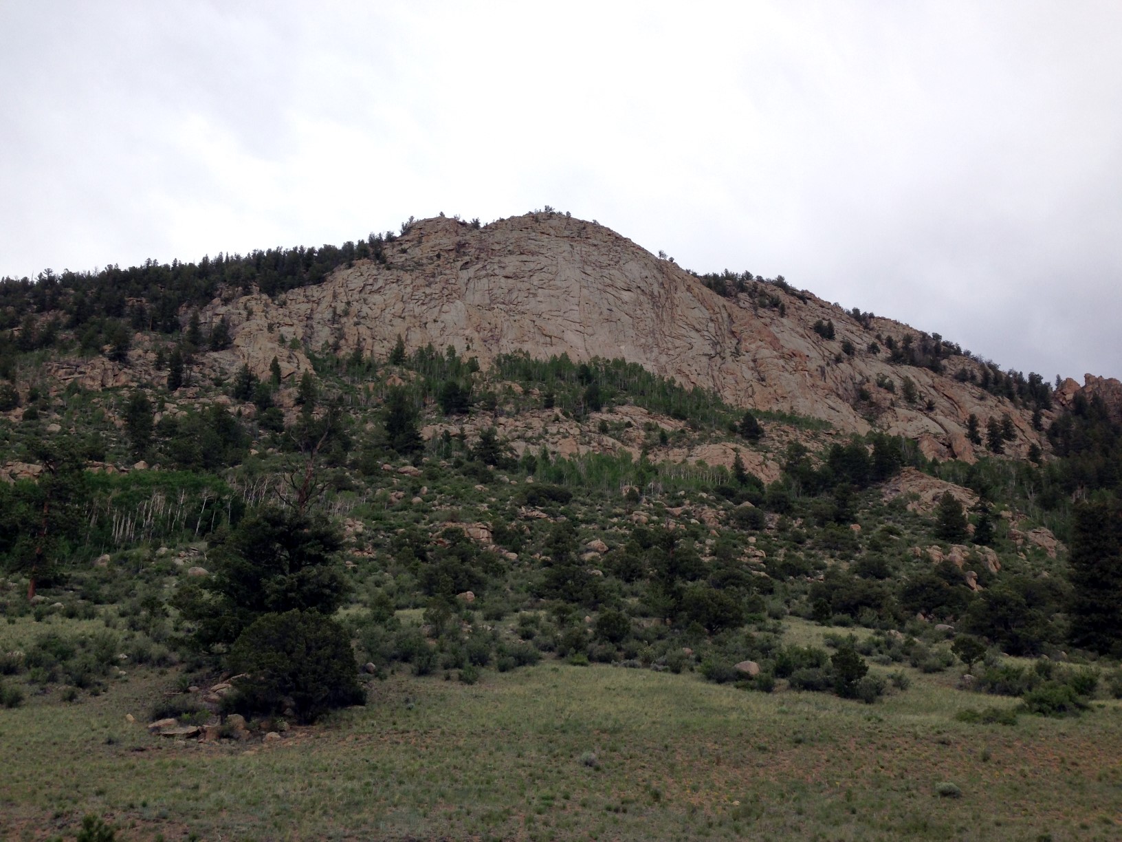
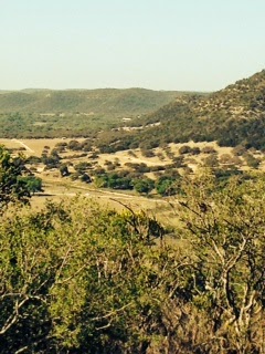
View of W0C/SP-089
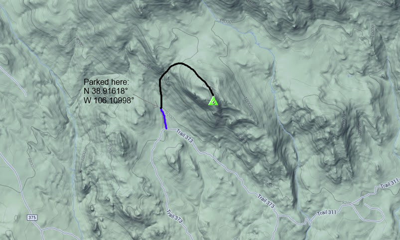
To reach the summit, we drove a 4WD truck from Trout Creek Pass on Forest Service Road 311, connecting to FS Road 373. Four wheel drive is required for this road due to the steep sections, which may not be passable in muddy conditions. You can also approach from the Buena Vista side, see the San Isabel Forest Service Map. From 373 we took a side road (shown in blue on the map below) that is not always shown on maps. I believe it is marked 373A but I am not sure. We parked the truck at the lat/lon shown.
From there we hiked a non-technical route to the west of the summit, working our way up through the draw shown on the map. There were a few faint game trails here and there but mostly it was some challenging bushwhacking up that draw. The willows and sticker bushes made us glad that we had long pants on. Also, there was quite a bit of downed timber to step over. The route got quite a bit easier once we got to the top of the draw, but still no trail. The elevation gain was only 1100 feet but it felt like a lot more work than that.
 As we neared the summit, I heard Bob (W0BV) calling me on 146.52 MHz. I had put out an email alert to some of the hams in the area so Bob and some others knew I was going to be out climbing. Once I got to the summit, I contacted Bob (W0BV) and quickly had a mini-pileup with several stations calling me. Mark (KF5WCY) visiting from TX gave me a call, followed by Carl (K5UK) near Mount Yale. Then I worked Jim (KD0MRC) in Buena Vista and Larry (KL7GLK) in Leadville. Thanks, guys, for getting on the air and contacting me!
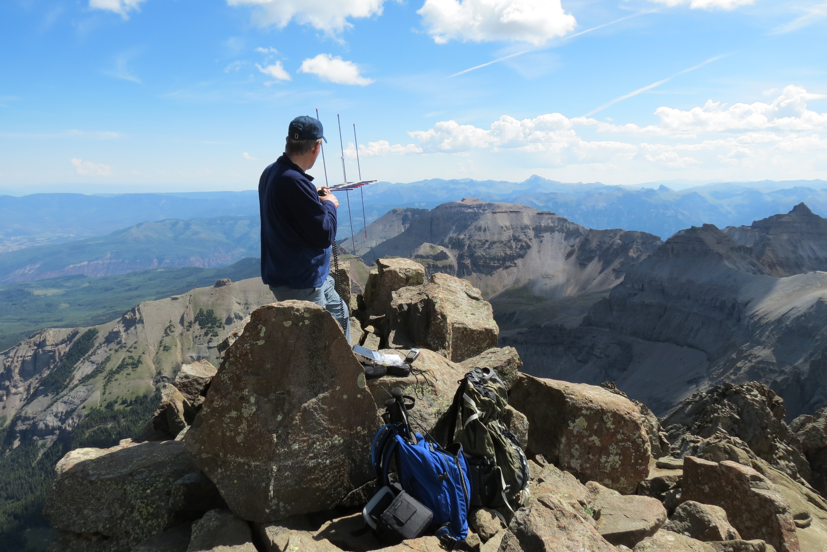
I used my Yaesu FT-60 handheld transceiver and a 1/2-wave vertical antenna for these contacts. While I had my 3-element Yagi antenna with me, I did not bother to set it up.
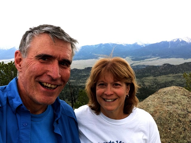
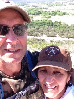
Bob (K0NR) and Joyce (K0JJW) on the summit
My spouse and hiking companion Joyce (K0JJW) and I have worked out a standard SOTA activating procedure. As we get close to the summit, she stops below the activation zone and I continue to the top. Then I work her on 146.52 MHz which guarantees a successful activation. It is possible to get skunked on 2m fm in the backcountry, so this is good insurance. This one QSO does not result in any SOTA points, since the rules require a minimum of four contacts for activation points. Next, Joyce joins me on the summit and we work whoever is out there. Lately, I’ve had pretty good luck getting at least 4 contacts on 2m fm. On the descent, she stays on the summit and I go down the mountain and work her once I am outside of the activation zone. That way, I am able to work the summit, too. Then she leaves the summit, catches up with me and we descend the rest of the way together.
For more information on VHF SOTA activations, see How To Do a VHF SOTA Activation.
73, Bob K0NR
How To Do a VHF SOTA Activation
The Summits On The Air (SOTA) program has really taken off in North America. SOTA originated in the UK in 2002, so it took a little while for it to make it across the Atlantic to this continent. The basic idea of SOTA is to operate from a designated list of summits or to work other radio operators when they activate the summits. The list of designated summits are assigned scoring points based on elevation and there are scoring systems for both activators (radio operators on a summit) and chasers (radio operators working someone on a summit). See this blog posting for links to tons of information.
Most of the operating is on the HF bands but there are quite a few VHF contacts on SOTA. Obviously, HF has the advantage of being able to work longer distances without too much trouble. Typically, the HF station is your classic portable QRP rig, portable antenna and battery power. (A portable power source is required and the use of fossil fuels is prohibited.) Being a VHF enthusiast, I prefer the challenge of making contacts above 50 MHz, so my SOTA contacts are usually on 2 Meters or 70 cm.
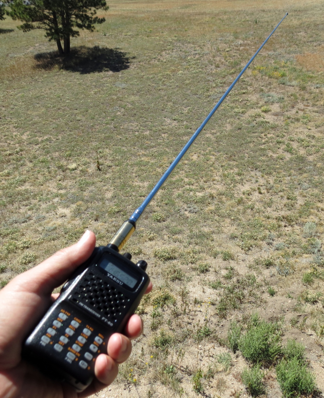
Handheld radio with 1/2-wave antenna
My basic VHF SOTA station is a handheld FM transceiver with a ½-wave telescoping antenna. The standard rubber duck on a handheld transceiver (HT) is generally a poor radiator so using a ½-wave antenna is a huge improvement. This simple station is an easy addition to my normal hiking routine…just stuff the HT and antenna in my backpack along with the usual hiking essentials and head for the summit.
To count as a SOTA activation, you need to make a minimum of 4 contacts from the summit. If I am hiking a summit within range of a major city, I can usually just make some random contacts by calling CQ on the National Simplex Calling Frequency, 146.52 MHz. However, operating in more remote areas requires a little more planning. I’d hate to hike all that way and come up short on the required contacts, so I use a few tactics to rustle up some VHF contacts. Of course, I will post my planned activation on the SOTAwatch site in advance, to let people know that I’ll be on the air. While this goes out worldwide, it may not reach the right radio amateurs within VHF range. The next thing I do is send an email to some of VHF-equipped hams I know will be within range. Many people respond to such a request to work a summit, even if they are active in SOTA. When on the summit, my first call is on 146.52 MHz or some other popular simplex frequency. If I don’t raise anyone there, I will make a call on a few of the 2M repeaters in the area to see if someone will come over to “five two” to make a contact. SOTA does not recognize repeater contacts but it is OK to solicit simplex contacts using a repeater. These techniques and a little patience have always gotten me at least four contacts, and usually quite a few more.
K0NR operating with 2M yagi antenna on Mt Sneffels
The omnidirectional antenna of the basic VHF SOTA station will make some contacts, adding some antenna gain can really help your signal. There are a number of compact directional antennas that are easy to take hiking. Elk Antennas makes a log-periodic antenna that covers 2 Meters and 70 cm. Another popular antenna is the 2 Meter / 70 cm Yagi antenna made by Arrow Antenna. These antennas are lightweight and assemble/dissemble easily, which is important to hiking radio operators.
So far, most of the SOTA VHF activity in North America is on on 2m FM, the utility mode. Everyone seems to have a 2m HT, so tossing it in a backpack and heading out is a natural thing to do. Using my FT-817, I have made some VHF contacts on CW and SSB. See this posting about a recent SSB activation. These modes are much efficient than FM and the station on the other end is likely to be a big weak-signal station. Nothing like a big gun station with huge antennas to help pull your QRP signal out of the noise! I expect the use of CW and SSB to increase on VHF as SOTA becomes more popular. While FM activity uses vertical polarization (antenna elements are vertical), most SSB/CW activity uses horizontal polarization (antenna elements are horizontal).
Summits On The Air is a great way to take ham radio outdoors. So get off the couch, find a summit and have some fun with ham radio.
See my other SOTA postings here.
73, Bob K0NR
KX3: Cool Go Box
Check out www.oe2atn.at/tom/gobox
If someone would commercialize this, I think it would be very popular.
Learning Morse code? Want to increase your skill?
Are you looking for some aids on learning Morse code, or to increase speed and skill? Let’s look at some great information and some software aimed at making your efforts successful.
(Note: I am not associated with any of the software. I just want to help you…)
I encourage you to look at the time-proven Koch method of learning Morse code. Below, we’ll look a little closer at this method of learning and honing your Morse code skill. In the meantime, if you just wish to skip the details, here are some software links for learning tools using the Koch method:
+ For the PC, I prefer the G4FON Morse code ‘Koch Trainer‘. It is a slick program that is set up to help you learn and enhance your skills with Morse code: http://nw7us.us/g4fontrainer – and his web site is at: http://www.g4fon.net/

G4FON Koch Trainer – Morse code learning on the PC
+ For the iPad and iPhone: On these devices, I use the ‘Koch Trainer’ by Nick / N3WG, found in the store here: https://itunes.apple.com/us/app/koch-trainer/id405137883?mt=8
+ For the Android: I use the same software as for the iPad and iPhone, the ‘Koch Trainer’ by Nick / N3WG, here: https://play.google.com/store/apps/details?id=com.n3wg.kochtrainer – however, note that it is not compatible on the S4.
+ Some other Android possibilities that I have not tried:
- https://play.google.com/store/apps/details?id=net.iz2uuf.cwkoch
- https://play.google.com/store/apps/details?id=uk.co.bitninja.kmtpro
Again, I have not tried those last few.
Now, let’s talk about the Koch Method of Morse code training!
From my page on the Koch method (text was used by permission from the author):
Koch’s method is a simple, direct way of building reflexes. However, it requires either a computer and Morse software or a personal trainer. That’s why it was overlooked for so many years. Now that computers are commonplace, it should become the standard Morse training method. Here’s how it works:
You start out by setting up your computer (or a microprocessor-based code tutor machine) to send you Morse characters at 20 wpm and at an overall sending speed of at least 15 wpm. You then get out your paper and pencil and have the machine start sending — but only two characters. That’s right, for your first sessions, you’ll only have two choices. Copy on paper for five minutes, then stop the machine and compare what you copied with what the machine sent. Count characters and calculate your percentage of correct copy.
If your score is 90 percent or better — congratulations! You just learned your first two characters, and, importantly, you learned them at full speed. You’ll never have to learn them over again. If you didn’t make 90 percent, practice some more. As soon as you can copy the first two characters with 90 percent accuracy, add a third character to your practice. Your accuracy will drop as you work on assimilating the new character, but it will rise again to 90 percent or better. Then you add the fourth character, and so on.
This method does not allow you to build that lookup table in your brain. To copy at full speed, you must build the reflexes in order to achieve 90 percent accuracy. And that’s what you’re spending your time doing — building reflexes. Think of it as a parallel to perfecting a tennis swing or mastering a gymnastic routine; you’re practicing until you get it right. The Koch method of building code proficiency character-by-character is similar to standard methods of teaching touch typing, another skill that must be reflexive.
…
While the Koch method is the fastest method of Morse training, speed alone is not its principal advantage. Its principal advantage, and a major difference from other methods, is that it provides you with constant positive reinforcement. This begins with your realization, after mastering the first two characters, that you can copy code at 15 or 20 wpm, because you just did it. After that, each new character mastered is further proof of your progress. Contrast that to slowly trying to build speed up from 4 or 5 wpm, then hitting the plateau at 10 wpm and seeing no progress for a long time. With the Koch method, frustration is at a minimum.
Constant testing is necessary to ensure that you maximize the effectiveness of the Koch method. You must copy on paper, so you can grade yourself. Remember, if you score 90 percent accuracy or better, add another character. If you score any less than that, try again. By constantly testing yourself on continuous copying of at least five minutes, you know exactly how you’re doing and exactly when you should add another character. This results in the fastest progress possible.
…
As you proceed toward your goal, remember that some days are just going to be better than others and some characters will take longer to assimilate than others.
(Read the entire article: the Koch method).
Again, here’s the PC software link: http://nw7us.us/g4fontrainer
And, here’s a web-based way to learn Morse code.
Good luck! If you have questions, please share them – I’m @NW7US
Music and Mountains
Memorial Day Weekend is therefore a Holiday weekend that finds many of us enjoying a three day weekend. The weekend was busy and memorable one for me. The weekend began with a 300 mile drive to play a show with my band, The No Refund Band, at a venue in Crystal Beach, TX. Crystal Beach is on the Bolivar Peninsula, east of Galveston Island on the Texas Coast. We had a great show there. (You can check out my band at norefundband.com )
The next morning (Sunday), my XYL Cris and I got in the Jeep and headed to the Ouachita Mountains in Oklahoma. This would be a 430 mile drive with the purpose of getting as many SOTA points as possible. The drive from Houston was very nice. North of Houston you take Hwy. 19 which goes through the piney woods of east Texas. Of course Texas is a big state and on this highway alone I went through Palestine, Athens, Canton and Paris. The road is nice and the speed limit is 70 - 75 mph and the traffic was light. As long drives go, this one wasn't bad.
The Ouachita Mountains cover southeastern Oklahoma and west central Arkansas. Along with the Ozark Mountains, the Ouachita Mountains form the U.S Interior Highlands, one of the major mountainous regions between the Rocky Mountains and the Appalachian Mountains. It is a beautiful area that is very green and lush with mountains and valleys that induce tranquility.
From a SOTA perspective I had done my research to find the most efficient route to accumulate the most points in relatively short amount of time. I had to be backon Tuesday for work, so I would have 24 hours get as many points as possible.
Sycamore Lookout W5O/OU-005 (8 pts)*
We arrived 20:15 UTC. The summit has easy access from the highway and I was QRV by 20:35. I set up next to the commercial antenna's with no RF issues. The bands were not in good shape and the WPX contest was in full swing. I made 10 QSO's in 25 minutes on 17 and 40 meters and decided to move on to the next one.
Peak 2210 W5O/OU-006 (8pts)*
This summit is just up the road a few miles and the highway is in the activation zone. I did ascend about 50 feet vertically to the summit. I set up just below the summit ridge. Unfortunately, the cell service was spotty and I wasn't able to spot myself. For some reason I wasn't picked up by the RBN network either. Consequently I called CQ for 10 minutes on 17m with no responses. I finally had cell service long enough to get a call off to Fred, KT5X, to ask him to spot me. It still took me 10 minutes after the spot to get my 4 QSO's. Conditions were not good.
Winding Stair Mountain W5O/OU-002 (10 pts)*
Winding Stair Mountain is a nice hike. The trail head is across the road from the Campground and the hike is about 3 miles roundtrip. We encountered a troop of Boy Scouts training for their upcoming 68 mile trek at the Philmont Scout Ranch in New Mexico. Conditions were only marginally better, I made 11 QSO's in 25 minutes.
After this summit we made out way to the Green Country Inn in Heavener, Oklahoma where we had a room. The hotel is a great place to stay if you find yourself in the area. The next morning began early to make sure we got to the summits we planned.
Lynn Mountain W5O/OU-001 (10 pts)*
Getting to this summit is best done with a 4WD vehicle. While a 2WD would make it most days, a 4WD is preferred. The road does enter the activation zone, but I took an ATV trail for the short walk to the summit. This summit is very green and overgrown so I operated from the trail. The weather was overcast and as I left the Jeep it started to rain. We were prepared with rain gear and umbrellas to provide a mini-shack on the summit. There was a light rain during the entire activation. Conditions were a little better and, since the WPX contest was over, 20m was available again. I was on the air at 1335 UTC, so I think I was a little early for propagation and some late rising operators. I made 12 QSO's on 20m and 40m.
Pigeon Benchmark W5O/OU-013 (10 pts)*
This summit is off the same road as Lynn Mountain. The hike to the activation zone is a 2 mile round trip. The trail to the summit is an overgrown ATV trail. The walking is easy with about a 220 foot elevation gain over the mile to the top. The grass on the trail is knee high and it was wet from the rain, so it was a very wet hike. Conditions were much better as I was QRV at 1510 and made 20 QSO's on 20 and 40 meters.
Rough Mountain W5O/OU-014 (8 pts) *
The road to this trail head requires a 4WD. The road crosses the Ouachita trail a about a mile in from Hwy. 259. This is nice 2.5 mile round trip hike with about 500 ft. elevation gain over the 1.25 miles to the summit. The trail is nice. I made 22 QSO's from here.
*Additional details on how to get to these summits can be found on the SotaWatch page for each summit
So there you have it, 54 SOTA points in 24 hours. We had a 500 mile drive home that we made in about 8 hours. So in total we traveled 1,200 plus miles to enjoy music and mountains to make memorable Memorial Day weekend.
A short highlight video can be found here:
https://www.youtube.com/watch?v=NZhGh-XATJ0
Texas SOTA Trip – The Law of Averages
As I have written here recently, the SOTA program recently added 40+ one point summits in South Texas. These summits are within a reasonable drive for me, so I was enthusiastic to activate them and after all, they are all one pointers, they should be easy enough. Just as a reminder for those who haven't caught the SOTA virus yet, point values range from 1 - 10. Oddly enough, 1 is the only odd number used in the valuation scale. Summits can be worth 1,2,4,6,8 or 10 points. Don't ask, I have no idea.
I've already activated Peak 2002, which was the first South Texas group summit activation. I ended up walking 8 miles for that point. Not to worry though, they can't all be that long. So in the spirit of adventure (and not point accumulation), I planned to activate two of these summits during the International SOTA day and the QRP to the field (QRPTTF) events. My two targets were Bullhead Mountain, W5T/ST-007, and Pikes Peak, W5T/ST-029. Yes there is a Pikes Peak in Texas. The one in Colorado is worth 10 points, the Texas version is worth, the aforementioned, one point.
I'd done my research and determined that there was a better than even chance these summits would be accessible. While on private land, these peaks are in sparsely populated areas that likely aren't posted. However you never know until you get there.
Bullhead Mountain, W5T/ST-007, is a limestone peak north of Vance (formerly Bullhead) and the intersection of Farm roads 335 and 2631 in far western Real County (at 29°49' N, 100°00' W). The summit, at an elevation of 2,042 feet above sea level, rises on the southern edge of the Edwards Plateau. Local vegetation includes open stands of live oak, Ashe juniper, and mesquite on the uplands and ridges and live oak and Ashe juniper woods on the hills and escarpments.
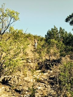 |
| The Trail up Bullhead, One of more open areas |
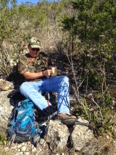 |
| Operating from Bullhead Mountain |
 |
| View from Bullhead Mountain |
The bands were a little finicky. Only made QSO's on 20 meters. Nothing on 12m despite the RBN hearing me at PJ2T.
 |
| Cris and I. Our Jeep is the black speck on the road |
 |
| View from Pikes Peak |
This summit was every bit as tough a Bullhead. There is a road that goes over the shoulder of the mountain which means you only have to climb 300 feet in about 1/3 of a mile. Again, that's steep and again no trails. I operated from the very top of the summit. A nice breeze cooled us down for the now 85F temperatures.
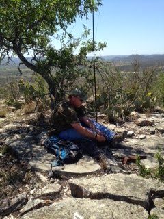 |
| Operating from the Summit of Pikes Peak, Texas |
We had contemplated doing Wildcat Peak also. Another one pointer, not too far from Pikes Peak, however, we were tired. These ascents and descents were taxing because of the steepness and the full time bushwhacking through brush and the temperatures were warming up. My thermometer in my jeep read 90F when we got down. We had a nice Texas lunch in Camp Wood. A lunch buffet with Mexican food and Chicken Fried Steak. It doesn't get much better than that.:-)
 |
| Cactus Flowers |
 |
| Texas Mountain Fauna |
So, what about this Law of Averages? Well, in the SOTA world there are some easy summits. Some you can even drive up to the summit or park near the top and take a nice trail a few yards to the summit. I have felt a little guilty about that in the past, getting so many points for so little effort, but no more. The Law of Averages does apply to SOTA. These one pointers were intense, difficult mountains to do. However, I suppose it all averages out. After doing these mountains, my guilt in doing an easy one has disappeared:-)
Photo credits to my XYL Cris, KC5HZQ
Excerpts above were taken from the Texas State Historical Association.
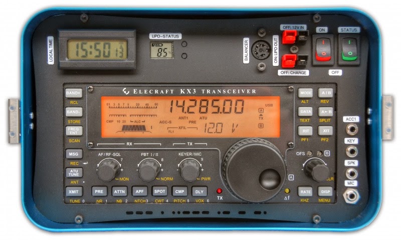
KX3 Heat Sink
If you operate your Elecraft KX3 in a portable environment (and perhaps even if you don’t) there are a few must-have add-ons which really help protect your KX3. You are probably already aware of the popular KX3 KX Endplates and KX Cover available from Scott, AK6Q and his Gems Products website. I received both as a Christmas present from my darling wife and love what they do for my KX3.
In addition to operating SSB phone via my KX3 on SOTA activations, I also enjoy grabbing my Buddipole a battery and heading outdoors for some picnic table portable operations in a park or really just about anywhere. In this setting I typically bring along my laptop and operate PSK-31 or JT-65. However, one thing I’ve noticed (and have been concerned about) is how the KX3 has the potential to heat up when running these digital modes (even at 5w or less). This is especially evident in the warmer months of the year.
A few weeks ago I was browsing the KX3 Facebook page and learned about an add-on heat sink designed, built and sold by a fellow ham in Canada. This OM’s name is Fred Meier, VE7fmn. I contacted Fred via email and he quickly provided a detailed response on how he designed his KX3 heat sink and provided cost and availability information. While I did find one other heat sink being marketed for the KX3, I believe Fred’s version is more effective at dissipating the heat from the KX3 and it looks great while doing it.
Here’s what Fred’s KX3 heat sink looks like installed on my KX3.


Fred’s KX3 heat sink is well built and designed to be durable. The fins on the heat sink are not going to bend or break off and only adds an additional 8 ounces of weight to the KX3.
I’ve conducted a few tests while in the shack and had the KX3 running PSK-31 and JT-65 at 10w and never received the overheat warning. I couldn’t run above 5 watts inside or outside the shack without the heat sink installed. I’ve yet to test the KX3 with heat sink installed outside in a portable setting, but I’m confident I will not have any issues. If you would care to read another review of VE7fmn’s heat sink, please go here.
As I’ve stated, I love operating portable with my KX3 and I’m Happy, Happy, Happy to have this wonderful add-on to help keep my KX3 Cool, Cool, Cool.
Until next time…
73,
Jerry


