Archive for the ‘ham radio’ Category
 Thirty Minutes of Dazzle: The Sun in UHD 4K by SDO (NASA)
Take a front-seat view of the Sun in this 30-minute ultra-high definition movie in which NASA SDO gives us a stunning look at our nearest star.
This movie provides a 30-minute window to the Sun as seen by NASA’s Solar Dynamics Observatory (SDO), which measures the irradiance of the Sun that produces the ionosphere. SDO also measures the sources of that radiation and how they evolve.
SDO’s Atmospheric Imaging Assembly (AIA) captures a shot of the sun every 12 seconds in 10 different wavelengths. The images shown here are based on a wavelength of 171 angstroms, which is in the extreme ultraviolet range and shows solar material at around 600,000 Kelvin (about 1 million degrees F.) In this wavelength it is easy to see the sun’s 25-day rotation.
The distance between the SDO spacecraft and the sun varies over time. The image is, however, remarkably consistent and stable despite the fact that SDO orbits Earth at 6,876 mph and the Earth orbits the sun at 67,062 miles per hour.
Scientists study these images to better understand the complex electromagnetic system causing the constant movement on the sun, which can ultimately have an effect closer to Earth, too: Flares and another type of solar explosion called coronal mass ejections can sometimes disrupt technology in space. Moreover, studying our closest star is one way of learning about other stars in the galaxy. NASA’s Goddard Space Flight Center in Greenbelt, Maryland. built, operates, and manages the SDO spacecraft for NASA’s Science Mission Directorate in Washington, D.C.
Charged particles are created in our atmosphere by the intense X-rays produced by a solar flare. The solar wind, a continuous stream of plasma (charged particles), leaves the Sun and fills the solar system with charged particles and magnetic field. There are times when the Sun also releases billions of tons of plasma in what are called coronal mass ejections. When these enormous clouds of material or bright flashes of X-rays hit the Earth they change the upper atmosphere. It is changes like these that make space weather interesting.
Sit back and enjoy this half-hour 4k video of our Star! Then, share. 🙂
73 dit dit
DX, Artificial Scarcity and The List
 Economists see scarcity, supply and demand as fundamental forces in a market. Items that are scarce demand a higher price while items that are easy to obtain tend to have a lower price. A diamond is an example of something that is relatively scarce (and in demand) so it commands a high price. In contrast, wood is generally available and is much less expensive than diamonds.
Then there’s the concept of artificial scarcity. If some items can be made scarce (or even just appear scarce), the price will tend to increase. For example, if I own all of the banana trees on an isolated island, I could reduce the available supply of bananas and command a higher price from all of the banana eaters there. Or maybe I start screening bananas for quality and I put a special sticker on them to brand them as special.
 We have a case of artificial scarcity in ham radio, called the DXCC list. This list defines what is considered a separate country when chasing DX. (Actually, the correct term is entity, not country.) For example, Hawaii (KH6) and Alaska (KL7) are considered separate entities even though they are part of the United States. (See Is Alaska a Country?) For someone chasing DXCC entities, because Alaska is on The List, a radio contact with Alaska becomes more desirable. It’s kind of like putting a “premium sticker” on a banana to indicate that it is special.
In my imagination, the DXCC list resulted from a bunch of hams sitting around drinking beer and bragging about how many countries they had worked. One guy, Larry says he just worked Hawaii, bringing his total to 125 countries. His buddy Leroy says, “You can’t count Hawaii because it’s part of the US of A.” To which Larry says, “You bet I can count Hawaii…and Texas too. It’s a whole ‘nuther country.” Clearly, we are going to need an official list to keep track of what counts as a country. A more credible version of how the list got established is captured in this article from the October 1935 QST.
Of course, the two main factors that drive scarcity of DXCC entities is the ham radio population and ease of access. Radio contacts are easy to make with entities that have an active ham population. If an entity doesn’t have many active hams but is easy to get to, someone will probably put that location on the air once in a while. On the other hand, some locations are unpopulated and really difficult to get to. These are not only on The List, they are on The Most Wanted List.
Kingman Reef (KH5) was just deleted from The List, instantly changing it from one of the most desired contacts in amateur radio to a big giant Why Bother. You see, there used to be 340 countries on the list but now there’s only 339. Kingman Reef will now be considered part of Palmyra/Jarvis, so it still has value for DXCC, just a lot less.
As I write this article, there is a major DXpedition (VKØEK) operating from Heard Island, an unpopulated island near Antartica. The only reason those guys are there is that Heard Island is on The List. Take a look at their web site and you’ll see how much time and energy has gone into activating this lonely island. Drop it from the list and suddenly a radio contact with this location is a lot less in demand.
So try to keep this all in perspective. There are lots of radio contacts out there to be made, some more interesting and desirable than others. It is appropriate and necessary that we have the DXCC list, to provide consistency in how we count countries, I mean entities. But really, it all traces back to Larry and Leroy arguing about who worked the most countries.
Thanks to the dedicated DXpeditioners that put these rare locations on the air.
73, Bob K0NR
The post DX, Artificial Scarcity and The List appeared first on The KØNR Radio Site.
Stunning Ultra-HD View; Sun Timelapse 2015 NASA/SDO
This video is ten minutes of coolness.
This cool time-lapse video shows the Sun (in ultra-high definition 3840×2160 – 4k on YouTube) during the entire year, 2015. The video captures the Sun in the 171-angstrom wavelength of extreme ultraviolet light. Our naked, unaided eyes cannot see this, but this movie uses false-colorization (yellow/gold) so that we can watch in high definition.
The movie covers a time period of January 2, 2015 to January 28, 2016 at a cadence of one frame every hour, or 24 frames per day. This timelapse is repeated with narration by solar scientist Nicholeen Viall and contains close-ups and annotations. The 171-angstrom light highlights material around 600,000 Kelvin and shows features in the upper transition region and quiet corona of the sun.
The first half tells you a bit about the video and the Sun, and you can see the entire year 2015 rotate by. The second half is narrated by a NASA scientist. It is worth watching all ten minutes. And, then, sharing!
The sun is always changing and NASA’s Solar Dynamics Observatory is always watching.
Launched on Feb. 11, 2010, SDO keeps a 24-hour eye on the entire disk of the sun, with a prime view of the graceful dance of solar material coursing through the sun’s atmosphere, the corona. SDO’s sixth year in orbit was no exception. This video shows that entire sixth year–from Jan. 1, 2015 to Jan. 28, 2016 as one time-lapse sequence. Each frame represents 1 hour.
SDO’s Atmospheric Imaging Assembly (AIA) captures a shot of the sun every 12 seconds in 10 different wavelengths. The images shown here are based on a wavelength of 171 angstroms, which is in the extreme ultraviolet range and shows solar material at around 600,000 Kelvin (about 1 million degrees F.) In this wavelength it is easy to see the sun’s 25-day rotation.
During the course of the video, the sun subtly increases and decreases in apparent size. This is because the distance between the SDO spacecraft and the sun varies over time. The image is, however, remarkably consistent and stable despite the fact that SDO orbits Earth at 6,876 mph and the Earth orbits the sun at 67,062 miles per hour.

A blending of an entire year, 2015, of the Sun as seen by NASA SDO at EUV 171 Angstroms
Why This is Important
Scientists study these images to better understand the complex electromagnetic system causing the constant movement on the sun, which can ultimately have an effect closer to Earth, too: Flares and another type of solar explosion called coronal mass ejections can sometimes disrupt technology in space. Moreover, studying our closest star is one way of learning about other stars in the galaxy. NASA’s Goddard Space Flight Center in Greenbelt, Maryland. built, operates, and manages the SDO spacecraft for NASA’s Science Mission Directorate in Washington, D.C.
For us radio enthusiasts, the study of the Sun helps us understand the dynamics of radio signal propagation. And, that aids us in communicating more effectively and skill.
Thanks for sharing, voting, and watching. More information and live Sun content can be accessed 24/7 at http://SunSpotWatch.com
You can also get the Space Weather and Radio Propagation Self-study Course at http://SunSpotWatch.com/swc
Yaesu FT-1DR: A Trail Friendly SOTA HT
A common topic in the QRP community is the Trail Friendly Radio (TFR) concept for backpack-style operating on the high-frequency bands. I’ve adapted the concept for the VHF/UHF bands, calling it the VHF Trail Friendly Radio (VTFR).

Strong candidates for the best VTFR include the Elecraft KX3 (with 2m option) and the Yaesu FT-817. Heck, both of these radios deliver all of the HF bands, 6m and 2m in one portable package. (The FT-817 also has 70cm.) See my blog post that compares the two rigs.
But the other set of strong contenders for the best VTFR is one of the many dualband HTs available on the market. It is hard to beat the compact, portable attributes of these great little radios for casual use on the trail. I’m not going to review them all but instead talk about my current favorite: the Yaesu FT-1DR. (Yaesu has recently replaced the FT-1DR with the newer model FT1XDR, which is the same design but with an improved GPS receiver and larger battery pack.)
My main usage of the radio is when hiking and doing Summits On The Air (SOTA) activations. This radio has a lot to offer in terms of capability and features, but the main things that stand out are 2m/70cm band coverage, two independent receivers and built-in GPS/APRS capability. Most SOTA VHF operating is on 2m fm so that band is critical, but I also make contacts on 70cm. More important is that together 2m and 70cm covers that vast majority of fm repeaters in my state, providing the best backcountry repeater coverage. The built-in APRS features allow the HT to be an effective tracking device as I move down the trail. SOTA chasers can see my position in real-time and anticipate when I’ll be on the summit. The radio has two separate receivers which turns out to be very useful when on the trail. With two receivers, I can monitor 146.52 MHz (2m fm calling frequency, often used for SOTA) while also keeping an ear on a local 2m or 70cm repeater. Another configuration is using one side of the radio to ping my location via APRS while the other side monitors 146.52 MHz.
The extended receive capability of the radio opens up lots of listening options: AM broadcast, FM broadcast, airband, shortwave and NOAA weather radio. I don’t use these very often but there are times that I want to tune to weather or news.
I am not a huge fan of Yaesu’s C4FM digital mode but do use it on occasion. The DN (digital narrow) mode supports voice and position information simultaneously, so Joyce KØJJW and have been using it to keep track of each other on the trail. The radio provides a basic indication of distance and direction to another C4FM radio.
One final note: if you buy an FT-1DR, I recommend upgrading the belt clip to the BC-102 clip from Batteries America. It is way better than the standard one from Yaesu.
73, Bob KØNR
The post Yaesu FT-1DR: A Trail Friendly SOTA HT appeared first on The KØNR Radio Site.
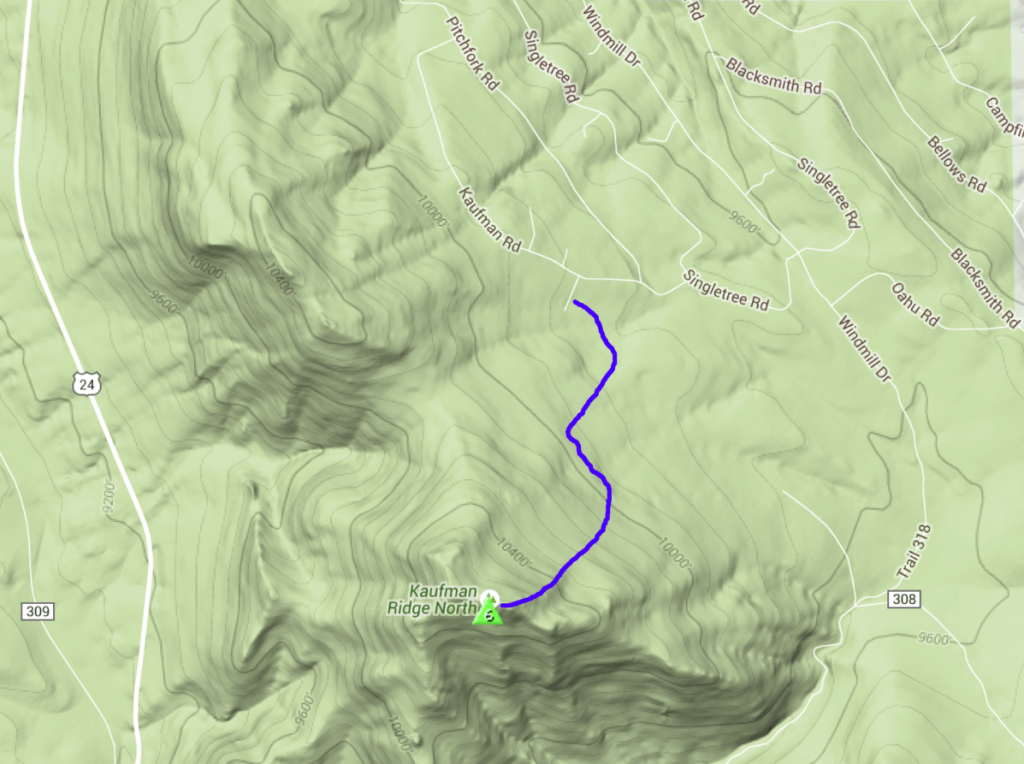
Winter SOTA Activation of Kaufman Ridge North
Today, Joyce KØJJW and I activated Kaufman Ridge North (W0C/SP-085) for Summits On The Air (SOTA). We’ve been on the summit before, including the first ever SOTA activation back in September of 2012. This summit is close to our cabin, so it made for a convenient hike. The mountain is not that difficult of a climb but we encountered quite a bit of snow in March, up to three feet in places, which we tromped across with snowshoes.
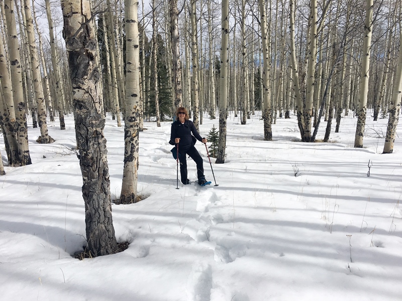
My blog posting about the next mountain to the south, Kaufman Ridge HP (W0C/SP-081), outlines a good way to access both summits during the summer. However, a seasonal gate closure (December to April) means we needed to find a different route. We approached the mountain from the north, parking our vehicle on Castle Court (a short side road off of Kaufman Road). We quickly crossed what appears to be private property (empty lot, no signs) to get to the US Forest Service boundary. Once we hopped the fence we were on public lands. We intentionally routed to the east to avoid some houses.
I don’t claim that this route is optimal. We had to break a lot of trail, pushing through the snow. We found a section of trail that had recent snowshoe traffic on it but it wasn’t of much use to us heading to the summit. We followed numerous game trails which appeared and disappeared on the side of the mountain. Mostly, we busted through the snow on our own. Surprisingly, the last quarter mile to the summit had little snow, so we removed our snowshoes at that point and just hiked in boots.
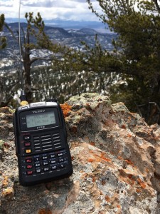 My Yaesu FT-1DR has become my favorite rig for SOTA activations. It covers both 2m and 70cm with dual-receiver capability. it has a built-in GPS receiver and APRS capability that facilitates easy APRS tracking. Joyce and I have a pair of these which we’ve been using to track each other’s positions on the few occasions we get separated on the trail.
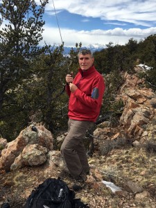
After we made the summit, I made a few contacts on 146.52 MHz. Thanks to Jim KDØMRC, Dave KØHTX, Carl K5UK and Candy KEØDMT for giving me my four required SOTA contacts.
The weather turned out to be better than predicted…partly cloudy and temps around 50 degrees F. On the way back down, we retraced our ascent path so we had more of a snowshoe trail to follow. I have to admit that this trip was a good lesson in how off-trail snowshoeing can really be a challenge. This was many times more difficult than a summer trail hike of equal length and elevation gain. Trip stats: 2.6 total miles, 1300 vertical feet.
At least, that’s my story and I’m sticking to it.
73, Bob K0NR
The post Winter SOTA Activation of Kaufman Ridge North appeared first on The KØNR Radio Site.
How-To: Send Perfect Morse Code by Hand (Vintage Video)
What is the proper (and most efficient) technique for creating Morse code by hand, using a manual Morse code key? Ham radio operators find Morse code (and the ‘CW’ mode, or ‘Continuous Wave’ keying mode) very useful, even though Morse code is no longer required as part of the licensing process. Morse code is highly effective in weak-signal radio work. And, preppers love Morse code because it is the most efficient way to communicate when there is a major disaster that could wipe out the communications infrastructure.
While this military film is antique, the vintage information is timeless, as the material is applicable to Morse code, even today.
More about Morse code, at my website: http://cw.hfradio.org
Thank you for watching, commenting, and most of all, for subscribing. By subscribing, you will be kept in the loop for new videos and more… my YouTube Channel: https://YouTube.com/NW7US
See my Video Playlist for related Morse code vidoes:
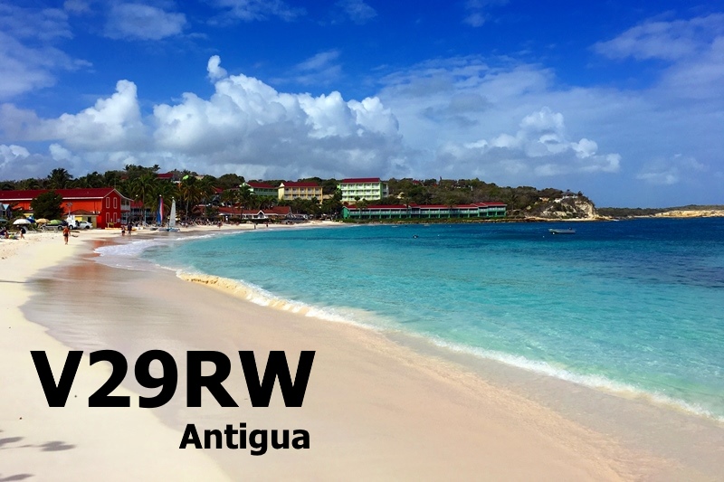
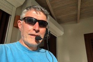
V29RW: Slacker DXpedition to Antigua
Recently, I had another opportunity to take ham radio along on vacation to a Caribbean island, this time to Antigua. This was not a super-gonzo turbo-charged DXpedition. I just worked in some radio action in between snorkeling and beach walking. This is referred to as a “holiday style” DXpedition, or maybe it’s just the slacker approach.
Radio Equipment
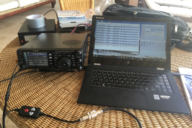
The radio gear needed to fit easily into my luggage. After all, we’ve got snorkel gear to take along. I wanted to put out a healthy signal from the island, so I rejected the idea of running QRP, opting instead for a 100W transmitter. Ultimately, I chose to take a Yaesu FT-991 which is full-power and full-featured but still relatively compact. It easily fit into my carry-on bag along with some other items. Having a built-in antenna tuner was a real plus and it was also good to have the 2m and 70 cm bands.
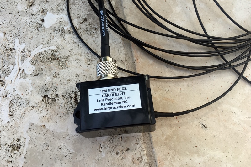
Choosing an antenna was a critical item. My first thought was to take my Buddistick antenna which covers the HF bands I was interested in working: 20m, 17m, 15m and 10m. I used that antenna from the Virgin Islands and it was really handy for taking to the beach. This time I wanted something bigger under the theory that size does matter. On the other hand, I wasn’t going to take full size yagis for each of the bands. I finally settled in on using End-Fed Half Wave (EFHW) antennas for the 4 bands (from LNR Precision). This gave me a simple half-wave antenna on each band with no coils, no traps, nothing funny going on. These antennas radiate well and have decent bandwidth…any SWR degradation can be tweaked up quickly using the FT-991 antenna tuner.
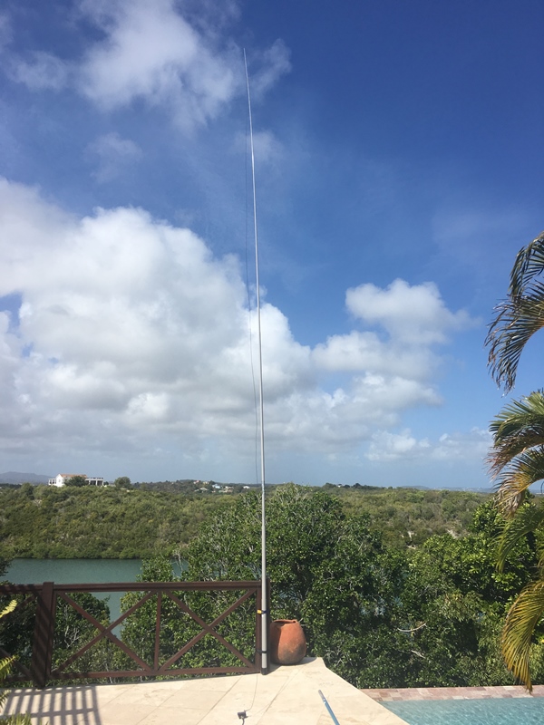
Steve WGØAT suggested I use the SOTABEAMS 30-foot mast to support the EFHW antennas. It is an incredible mast that collapses to 26.5 inches, small enough to fit into my bag. This antenna set up is common with the SOTA activators: EFHW supported by some kind of lightweight pole. I also tossed in a 19-inch magmount antenna for 2m and 70cm. (I did find a good repeater on on 147.0 MHz but did not spend much time on it.)
Rounding out the kit was an Astron switching power supply, a 25-foot length of RG-8X coaxial cable, a Heil Traveler headset and a few patch cords. I found it tempting to keep throwing more stuff in the bag so I adopted the backpacker mentality of taking just what I needed and not much more. For computer logging, I chose N1MM Plus software, set to log type to “DX”.
I have to confess that I did manage to break the 30-foot mast early in the trip. The house was on a hill and we always had a strong breeze coming through. One day it flexed the mast enough to break it. This was quickly repaired with duct tape. After that, I did not use the 2 top sections of the mast which reduced the amount of sway in the wind (and stress on the mast).
On The Air
My operating time was a bit sporadic and my operating strategy was simple: work the highest band (of 20m, 17m, 15m and 10m) that had some decent propagation to somewhere. Antigua is not extremely rare but it seemed to attract attention. Typically, I called CQ, worked a few stations and then a big pileup would develop. I made lots of QSOs with stations in North America, South America and Europe. I also made a few contacts into Africa but none with Asia. Signal reports were generally good (S9 +), so the antennas were doing the job.
All in all, I was pleased with the contacts I made, given the slacker effort. I especially enjoyed working 17m, a band I have not spent that much time on. The propagation is similar to 20m but noticeably less jammed with signals.
  Band  QSOs DXCC
    14   309   36
    18   162   13
    21    21   10
    28    91    6
 Total   583   65
QSLs for V29RW should be sent to my home callsign: KØNR (direct or via the bureau). Logbook of the World contacts have already been confirmed. Instant gratification, baby!
73, Bob KØNR, V29RW
Licensing info: It was relatively easy to get a ham radio license in Antigua, based on my US license (fees were $30 US). See this web page.
The post V29RW: Slacker DXpedition to Antigua appeared first on The KØNR Radio Site.


