Archive for the ‘ham radio’ Category
 This Spewed Out of the Internet #35
 I noticed that I’ve been blogging mostly about SOTA activations, so here’s something completely different: a bunch of exciting stuff flowing forth from the interwebz.
From the Why Do They Do That Department, Jeff/VA2SS shared this article on the origin of the radio term “Roger That.” See The story of why pilots say “Roger that”
This reminds me of the classic scene from the movie Airplane, with the flight crew named Roger, Victor and Clarence.
I recently came across the Wikipedia web page on Etymology of Ham Radio, which explains the origin of the term “ham radio.” Etymology: the origin of a word and the historical development of its meaning. About the same time, Dan/KB6NU wrote about the use of the term “ham radio”: HAM? HAM radio? ham radio? Amateur Radio? amateur radio! I have to admit that I do get annoyed by people that write “HAM” in all caps. What the heck is that?
The ARRL recently published a series of six posters promoting the value of amateur radio. I’m not quite sure where to deploy these but I do like them.
I was checking on electrical voltages and plugs in various countries and came across this site: Power Plugs and Sockets of the World Very handy and easy to use.
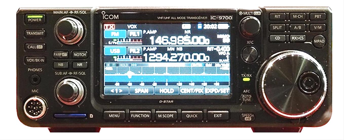
Twitter was abuzz with news about a new VHF/UHF transceiver from ICOM: the IC-9700. This is the first new radio aimed at VHF and up enthusiasts in a long while. I try to not get excited about these early product teasers and wait until the product is shipping in quantity. But I have to admit that this radio has my attention. I don’t have a lot of Icom gear in the shack but this radio may change that.
The DX Engineering web site shows these key features for this unreleased product:
Direct-Sampling SDR design
Three bands: 144 and 432 MHz (50 Watts), 1.2 GHz (10 Watts)
High definition Real-Time TFT display
Main and Sub RX
Dual Real-Time Spectrum and Waterfall displays
Dual Watch (with Spectrum/Waterfall displays)
Touchscreen interface (LCD touch-screen control)
That’s some good stuff spewing from the internet. What did I miss?
73, Bob K0NR
The post This Spewed Out of the Internet #35 appeared first on The KØNR Radio Site.
SOTA Activation: North Kaufman Ridge (W0C/SP-085)
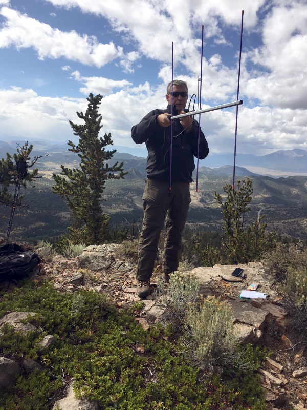
Kaufman Ridge is a ridge line that runs along the border of Park and Chaffee Counties in Colorado, near Trout Creek Pass. There are two Summits On The Air (SOTA) summits on this ridge: Kaufman Ridge (W0C/SP-081), formerly Kaufman Ridge HP, and North Kaufman Ridge (W0C/SP-085), formerly Kaufman Ridge North. I have activated these summits before including a winter activation of North Kaufman Ridge. These summits have turned out to be popular SOTA activations because they are easy to access, easy to hike and have outstanding views of the surrounding area.
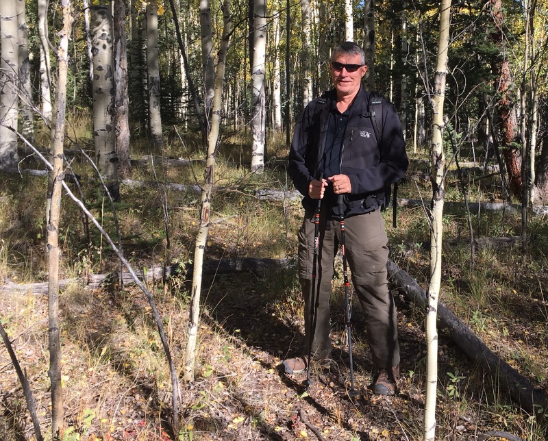
Joyce/K0JJW and I decided to do a SOTA activation on a pleasant September day. On previous trips, we approached the summit from the east without much thought to the route. This time we approached from the north, based on a tip from other SOTA activators. This route is a little bit longer than coming from the east but it turned out to have fewer steep spots and less downed timber to navigate.
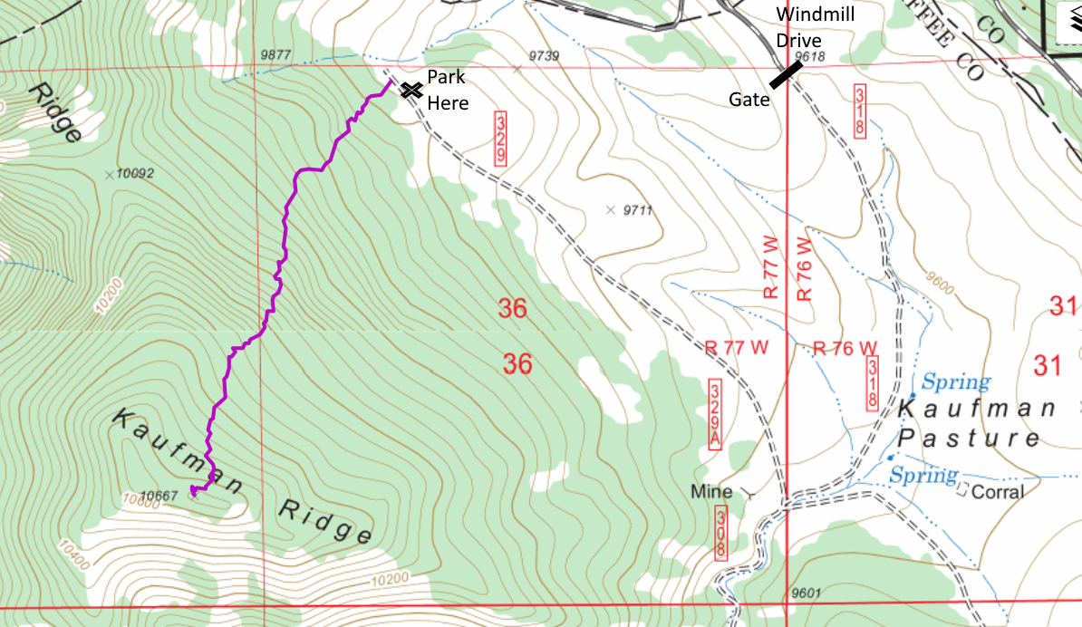
To get to the start of the hike, we went south on Windmill Drive to FS 318, entering the San Isabel National Forest. There is a gate at the entrance to the forest that is closed from December to April. We turned right onto FS329, which may not be marked but is an obvious 4WD road heading to the north. We drove to the end of the road and parked near the National Forest boundary. These are really easy 4WD roads such that a high-clearance 2WD vehicle should have no problem.
At this point, we aimed straight at the summit and started hiking. We found only bits and pieces of a trail here and there. Someone has attempted to mark the trail in places but it was difficult to follow. No worries though as the route was relatively smooth without many obstacles such as rock formations and difficult downed timber. We had to do some minor route finding but just looking ahead for obstacles was sufficient. The one-way distance was 1.1 miles with a vertical gain of 800 feet.
On top, we both snagged plenty of radio contacts on VHF/UHF and enjoyed the excellent views in all directions. This made for a nice SOTA activation on a sunny fall day!
73, Bob K0NR
The post SOTA Activation: North Kaufman Ridge (W0C/SP-085) appeared first on The KØNR Radio Site.
Do You Travel? Don’t Forget Your Ham Gear! – ETH087

In this episode of the Everything Ham Radio Podcast, we talk with Vance Martin, N3VEM, about how he takes his Ham Radio Equipment with him when he goes on business trips. If you travel at all, you know the boringness of sitting in a hotel room after working all day, right? Maybe it is a new city, or maybe you have to be up early and don’t want to “go out” and be out late so you are able to function the next day.
So why not take your ham radio equipment with you while you travel and use that down time to make some contacts? This can also give you a chance to get out of your shack and get some fresh air and make some contacts to boot.
Vance and I talk about everything from what he does before he leaves, to what to do at the airport to how he operates while he has down time while traveling. Check out the show notes and listen to the episode by following the link below:
Magnitude X8 X-ray Flare of Sept 9 2017 (2nd Biggest in Cycle 24)
The sun erupted with an X8 solar flare, one of the largest of the current solar cycle (Sept. 10, 2017). Its source was the same sunspot region that produced an X9 flare last week. We show this in two wavelengths of extreme ultraviolet light at the same time, and each reveals different features. Both are colorized to identify in which wavelength they were observed. The coils of loops after the flare are the magnetic field lines reorganizing themselves after the eruption. The video clip covers about six hours.
FCC Opens 630/2200 Meters Amateur Band; Pre-Registration Required!

Yes, the headlines read, “FCC OPENS 630/2200 METERS TO AMATEUR USE AS OF OCTOBER 16, 2017; PRE-REGISTRATION REQUIRED.”
The FCC has authorized amateur radio use of the 630 and 2200-meter bands, effective October 16, 2017, providing registration procedures have been followed and no objections are received within 30 days.
The PLC (Power Line Communications) database is live and hams may begin registering immediately. They may begin operating on 472 kHz (630 meters) and 137 kHz (2200 meters) as early as October 16 if they register today and receive no objection in the next 30 days. Hams may not operate on the bands without going through this process.
Please fill out the UPC Form, today, to register your station, even if you don’t have any plans on transmitting on these new bands.
It is imperative that all amateurs register, even if they don’t plan to use these bands in the near future, as the FCC rules prohibit UTC (the Utilities Technology Council) from deploying PLC in these bands closer than one (1) kilometer from registered stations. Registration now will protect your ability to use our new MF/LF bands in the future.
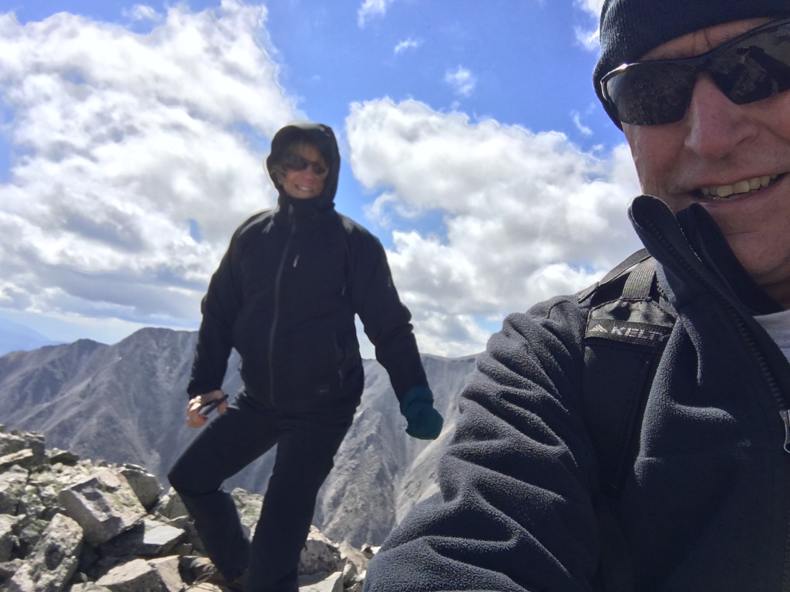
Mount White: Easy SOTA With A Jeep
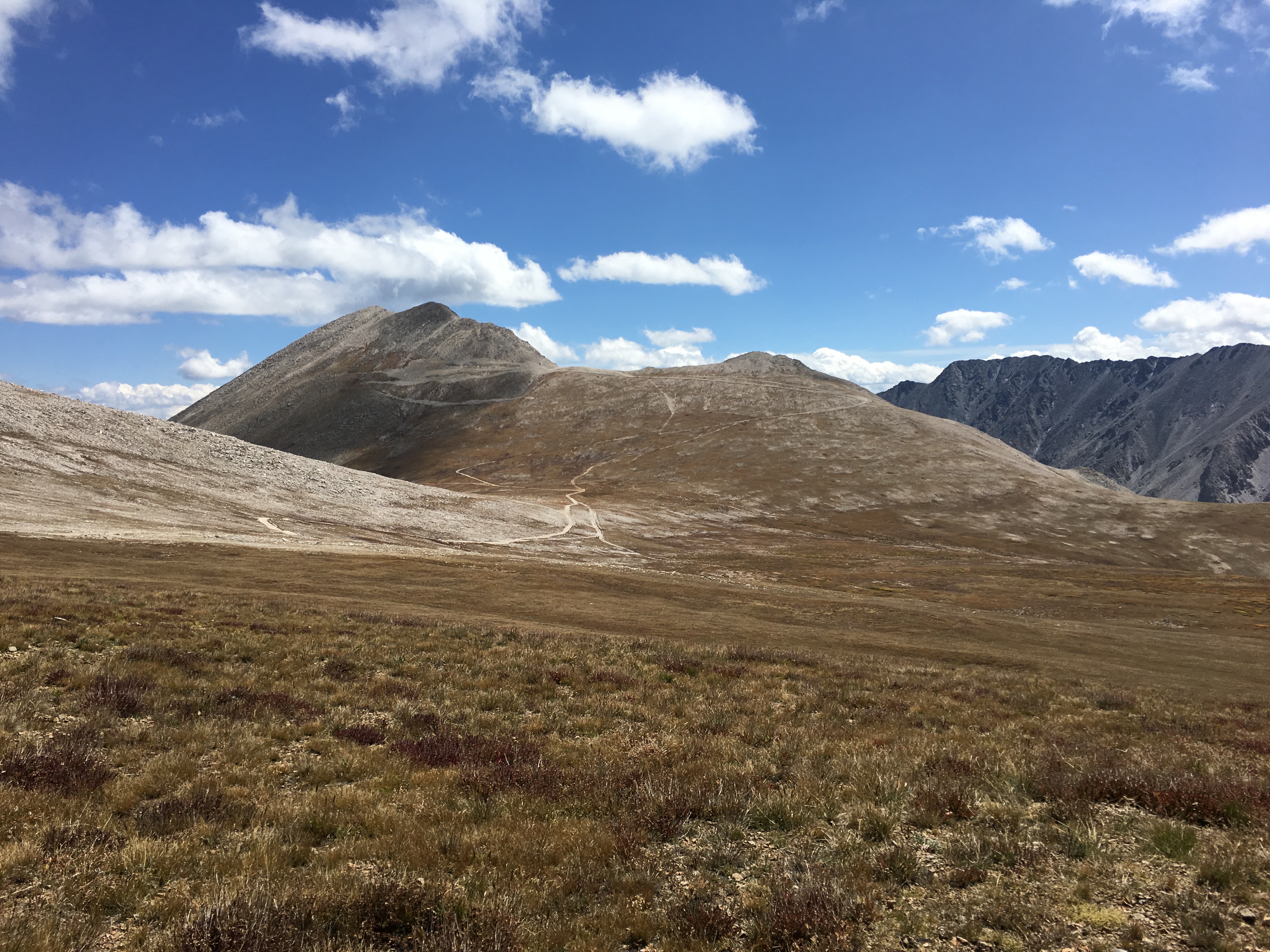
Mount White (W0C/SR-021) is 13,667 feet in elevation, just south of its big brother Mount Antero (W0C/SR-003) at 14,269 feet. Joyce/K0JJW and I activated this summit on SOTA using VHF/UHF. There had only been 4 activations of Mount White, which is a bit surprising. It is not that difficult to get to…if you have a decent 4WD vehicle. We have a stock Jeep Wrangler that handled the road just fine, but I would suspect that a AWD crossover (e.g., Subaru) or similar would not be adequate. We saw a number of hikers on the road (probably headed to Antero), so that is always another option.
The Mount White / Mount Antero area is covered with mining claims and old mining roads. This may degrade the hiking experience but does provide some decent 4WD roads to access the area. The Summitpost.org posting on Mount White has some interesting geological information about Mount White and Mount Antero. There are two summits on Mount White and Summitpost says the actual summit of Mount White is the eastern one. However, the SOTA database indicates the western one. Some other maps also indicate Mount White as the summit to the east but I believe the SOTA information is correct. I guess for SOTA purposes, it is correct, by definition.
A San Isabel National Forest map is very helpful for figuring out access to this summit. Basically, you head west on County Road 162 towards Mount Princeton Hot Springs. Eventually, you’ll get to FS 277 which is a moderate 4WD road marked as the road to Mount Antero. Take a left turn onto FS 278 and follow that uphill to eventually take a left turn onto FS 278A. Stay on 278A for a very short time, then take a right onto FS 278B which takes you to the saddle below Mount White. (See map below.) This route does require good vehicle ground clearance. There are two stream crossings and many tight switchbacks. All in all, it was an easy-peasy fun trip with our stock Jeep Wrangler.
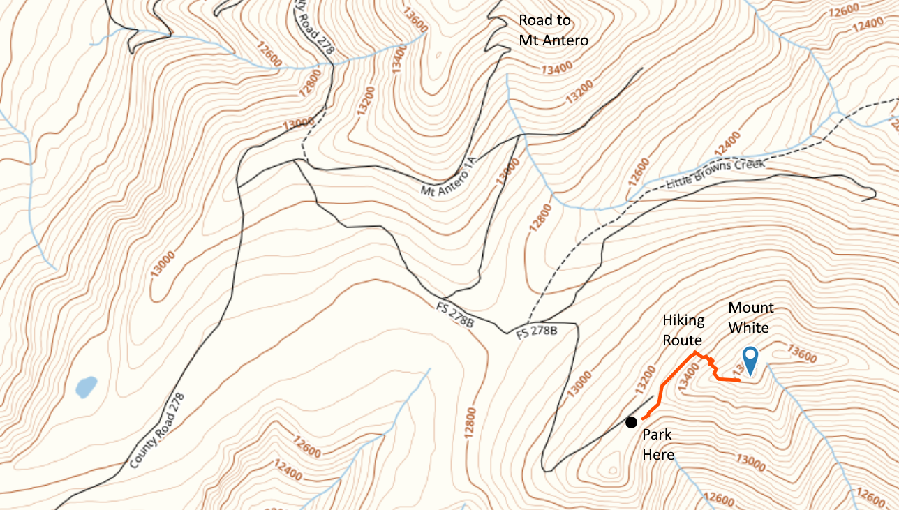
The hiking route is not difficult: 0.35 Miles one way and 450 feet vertical. But you are above 13k feet, so expect the oxygen to be thin. We started out by following a road along the north side of the peak, then scrambled up the talus to the summit. There are bits of pieces of “trail” but we did not find an established hiking route. The day we were there in September it was extremely windy so we did not stay long.
Mount Antero is close by so you could do both summits on the same trip, assuming the weather cooperates.
73, Bob K0NR
The post Mount White: Easy SOTA With A Jeep appeared first on The KØNR Radio Site.
Talking JT Modes with Ria Jairam, N2RJ – ETH085

In this episode of the Everything Ham Radio Podcast, we talk again with Ria Jairam, N2RJ. This time we are talking about the different JT Modes, JT65, JT9 and the new FT8!
We talk about its uses, how to operate and what you need to operate the different modes.
Check out the show notes to listen to the episode as well as get links to all the different things that we talk about at:


