Posts Tagged ‘summits on the air’
 First SOTA activation – Normanby Top G/TW-005

After last weekends disappointment I had purchased a new Baofeng UV-82L dual band for the princely sum of £27 from eBay to replace the suspect UV-5R. It certainly seems more sensitive when receiving and the transmit audio is loud and clear.
With the 'flower-pot' antenna in the rucksack I spent the walk monitoring the local repeaters (and could hear the regular idents) as well as the calling channels. I was putting out the odd call (with little success) when we stopped to allow the wife to search for the geocaches.
 |
| One man and his dogs |
I had been spurned on to have a go at an activation after watching a video of Michael Sansom's (G0POT) presentation on the SOTA scheme for the Chertsey Radio Club. The video is available online here and Michael has written an excellent companion introduction to SOTA on his website http://peanutpower.co.uk/sota
 |
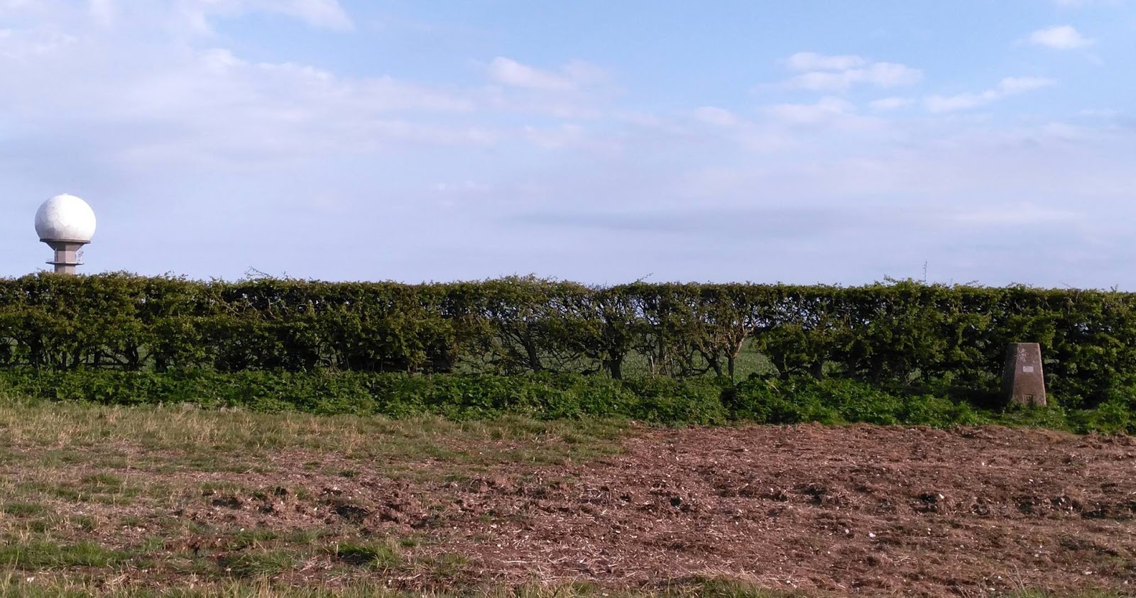
| View across to radar station on Normanby Top |
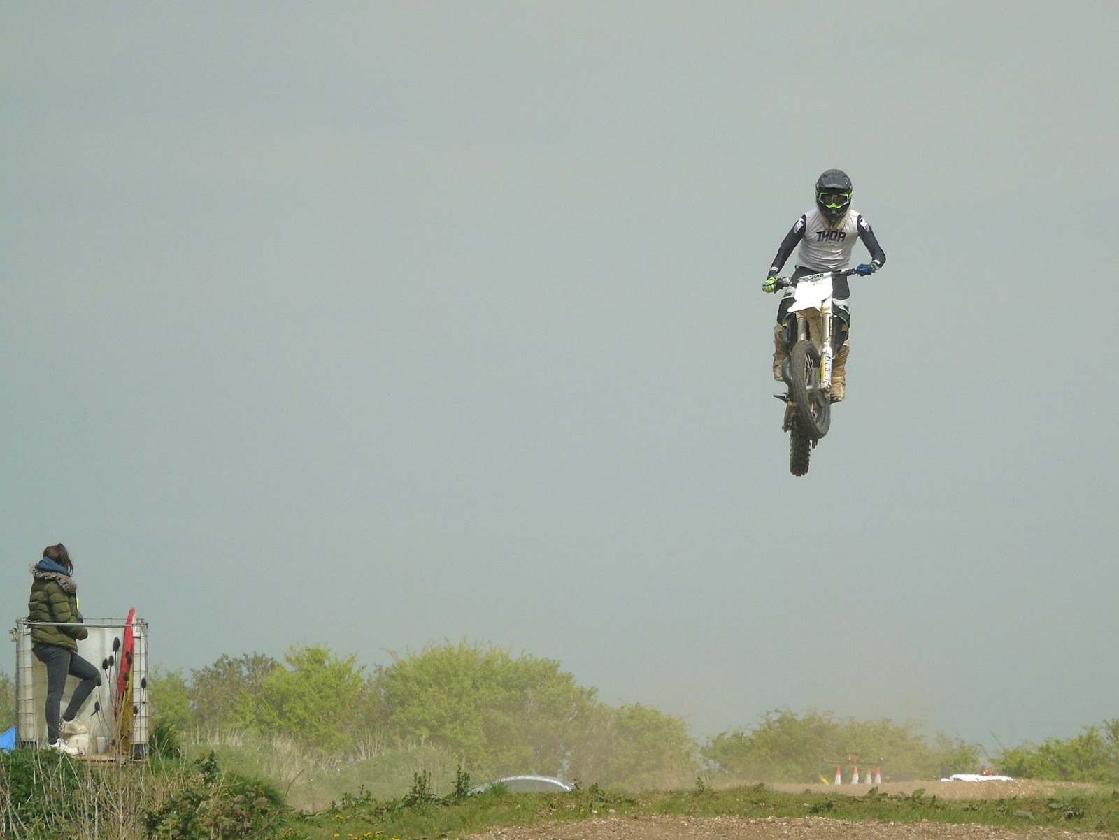 |
| Saw some spectacular jumping skills |
 |
| Section of the 1:25000 Ordnance Survey Map |
To the South of the summit is a road with an air-traffic control radar station. We parked up near this impressive structure to have some very late lunch (time had flown by)
 |
| Radar Station on Normanby Top |
I had a friendly chat with him and he was fully aware of what I was doing and had no issues having met other activators in the past. He also gave me permission to walk across his land up to the trig-point if I wanted to. As I've mentioned it isn't on a public right of way but said he is more than happy for people to go to the trig-point providing they ask at the farm before hand and take home all their rubbish, unfortunately he has some recent problems with inconsiderate litterers.
I decided to decamped and following his instructions to a gap in the fence and set off to the trig-point which was a little bit further away and a little steeper than I thought, but it didn't help I was carrying a half made up antenna, poles and a bag full of kit and my not inconsiderate bulk! Anyway I got there but due to us running already behind schedule and my change of location it was getting late in the day and was nearly 5pm.
 |
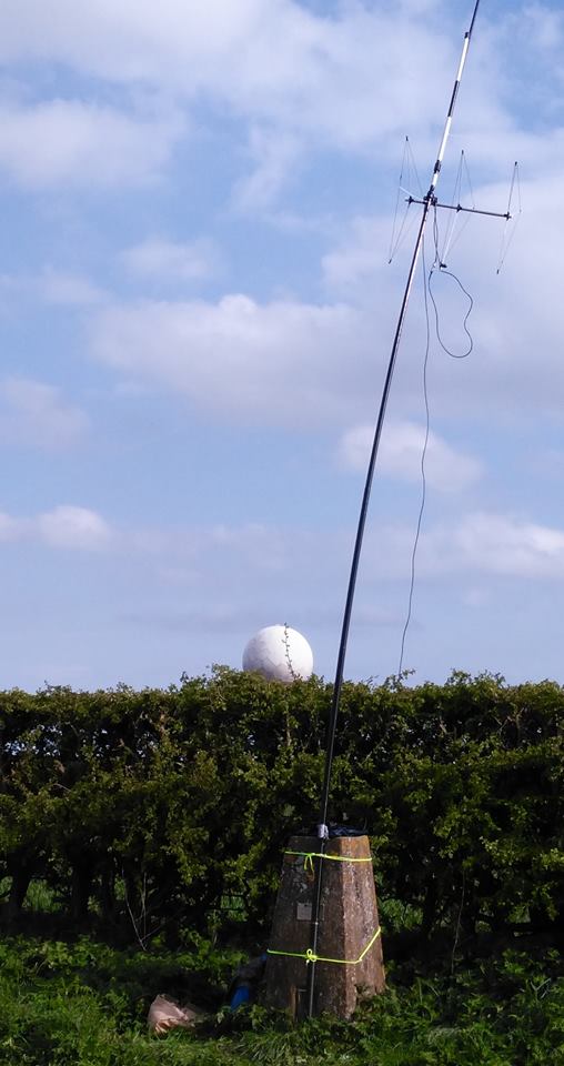
| Trig-point and radar station behind |
I had taken my Yaesu FT-857D, two 7Ahr SLA batteries, fibreglass pole, antennas for 20m/40m HF, 2m SSB and 2m/70cm FM. Yes I'd travelled light! Having some lovely clear views all around I decided to try some 2m 'line of sight' contacts.
I put up the Sandpiper Delta Beam for SSB (horizontal) and my 'flower-pot' dual band for FM (vertical) on a fishing pole. The wind had started to pick up and I'd not got any proper bungee cords (doh!) so I lashed it up using guy ropes around the pillar.
 | |
| It was straighter than this before I went to take photo |
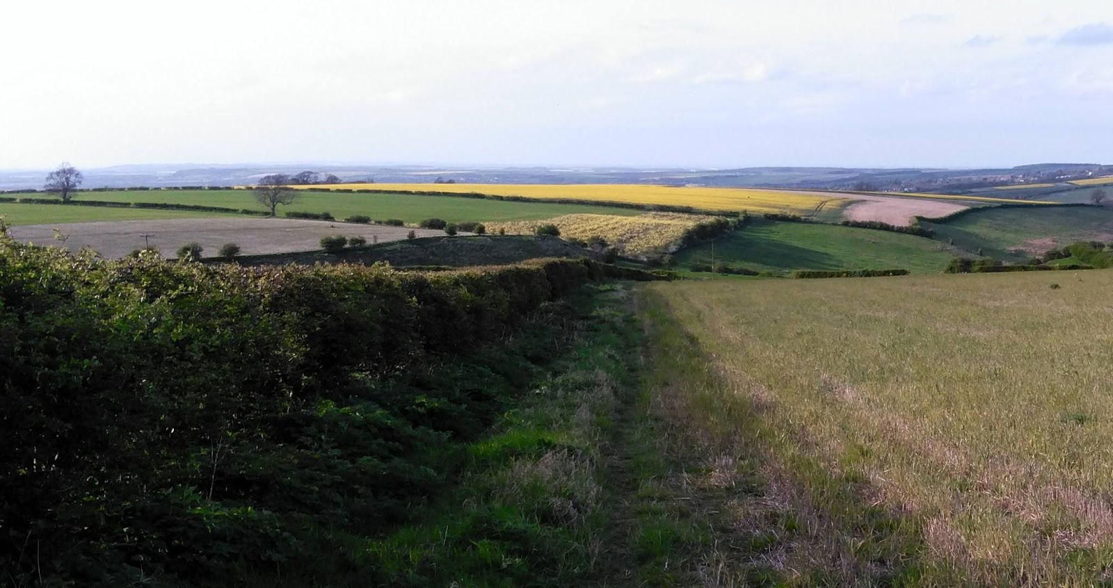 |
| View North (Humber to the top left) |
I really enjoyed myself but wished I'd allowed myself more time, this was in part because it was a late decision in the week to tack the 'summit' on the end of a day out walking and changing my mind to actually go to the summit given the chance but it was nice to do that for my first SOTA but I really need to get the hang of travelling light.
 |
| Back down and met by the wife who wanted her shopping bag back |
"Geocaching is like a high tech Easter egg hunt. People hide caches – waterproof containers containing a logbook and maybe some little trinkets – and then post the GPS coordinates to a Web site like geocaching.com. Others will search the site for caches in an area of interest, then use their own GPS (and intuition and woodcraft skills) to try to find them. Anyone who finds a cache signs the logbook, may take one of the trinkets and/or leave a new one, then goes back to the Web site and reports that they found that cache. There’s quite a community of geocachers, and it’s been going on for over a decade."
First SOTA activation – Normanby Top G/TW-005
After last weekends disappointment I had purchased a new Baofeng UV-82L dual band for the princely sum of £27 from eBay to replace the suspect UV-5R. It certainly seems more sensitive when receiving and the transmit audio is loud and clear.
With the 'flower-pot' antenna in the rucksack I spent the walk monitoring the local repeaters (and could hear the regular idents) as well as the calling channels. I was putting out the odd call (with little success) when we stopped to allow the wife to search for the geocaches.
|
| One man and his dogs |
I had been spurned on to have a go at an activation after watching a video of Michael Sansom's (G0POT) presentation on the SOTA scheme for the Chertsey Radio Club. The video is available online here and Michael has written an excellent companion introduction to SOTA on his website http://peanutpower.co.uk/sota
|
| View across to radar station on Normanby Top |
|
| Saw some spectacular jumping skills |
|
| Section of the 1:25000 Ordnance Survey Map |
To the South of the summit is a road with an air-traffic control radar station. We parked up near this impressive structure to have some very late lunch (time had flown by)
|
| Radar Station on Normanby Top |
I had a friendly chat with him and he was fully aware of what I was doing and had no issues having met other activators in the past. He also gave me permission to walk across his land up to the trig-point if I wanted to. As I've mentioned it isn't on a public right of way but said he is more than happy for people to go to the trig-point providing they ask at the farm before hand and take home all their rubbish, unfortunately he has some recent problems with inconsiderate litterers.
I decided to decamped and following his instructions to a gap in the fence and set off to the trig-point which was a little bit further away and a little steeper than I thought, but it didn't help I was carrying a half made up antenna, poles and a bag full of kit and my not inconsiderate bulk! Anyway I got there but due to us running already behind schedule and my change of location it was getting late in the day and was nearly 5pm.
|
| Trig-point and radar station behind |
I had taken my Yaesu FT-857D, two 7Ahr SLA batteries, fibreglass pole, antennas for 20m/40m HF, 2m SSB and 2m/70cm FM. Yes I'd travelled light! Having some lovely clear views all around I decided to try some 2m 'line of sight' contacts.
I put up the Sandpiper Delta Beam for SSB (horizontal) and my 'flower-pot' dual band for FM (vertical) on a fishing pole. The wind had started to pick up and I'd not got any proper bungee cords (doh!) so I lashed it up using guy ropes around the pillar.
| |
| It was straighter than this before I went to take photo |
|
| View North (Humber to the top left) |
I really enjoyed myself but wished I'd allowed myself more time, this was in part because it was a late decision in the week to tack the 'summit' on the end of a day out walking and changing my mind to actually go to the summit given the chance but it was nice to do that for my first SOTA but I really need to get the hang of travelling light.
|
| Back down and met by the wife who wanted her shopping bag back |
"Geocaching is like a high tech Easter egg hunt. People hide caches – waterproof containers containing a logbook and maybe some little trinkets – and then post the GPS coordinates to a Web site like geocaching.com. Others will search the site for caches in an area of interest, then use their own GPS (and intuition and woodcraft skills) to try to find them. Anyone who finds a cache signs the logbook, may take one of the trinkets and/or leave a new one, then goes back to the Web site and reports that they found that cache. There’s quite a community of geocachers, and it’s been going on for over a decade."
WØC/FR-030 (Chief Mountain) 3569m / 11709ft
On Sunday, 7 August 2016 I completed my 9th SOTA activation. Which I realize doesn’t sound like very many considering I completed my very first SOTA activation in November of 2011. Between November 2011 and November 2012 I added seven more to the list. Then I got sick, got busy, had some personal issues and before I knew it the summer of 2016 was quickly slipping away.
For those who have followed my other blog and my podcast (Practical Amateur Radio Podcast), you are aware I started exercising and eating better to get in better shape and lose weight. While I’ve taken over 10 million steps, walked just short of 5,000 miles and climbed 22,000 floors since I started wearing my Fitbit in the summer of 2013, today was the first SOTA activation I had attempted since losing over 50 pounds. While I’m presently in a weight holding pattern, I still make every effort to complete 10,000 steps per day. This walking has kept me in pretty good shape considering where I was just a few years ago. Best I can remember, it took me over 2 hours to hike to the summit of Chief Mountain in 2013.
The trailhead of Chief Mountain is about 40 minute drive from my QTH. As Chief Mountain is extremely popular with hikers/peak baggers I wanted to get an early start. I arrived at the trailhead just after 6:30 AM. With my boots tightly laced and my pack strapped to my back, I hit the trail at 6:45 AM.

The above trail sign is approx. 1 mile from the trailhead parking area and 2 miles below the summit.
One hour and five minutes later I’m standing on the summit of Chief Mountain. The total trail length is approx. 3 miles with a total elevation gain of just under 1,000. This is a great hike and I highly recommend it.
My SOTA HF setup hasn’t changed since 2012. If it works, why mess with it? I use a Buddipole vertical setup with a single wire counterpoise. For this activation I setup for the 20 meter band. I pack enough hardware to create a full-size 1/4 wave length vertical (no coil) along with a 1/4 wave length elevated counterpoise. With band conditions being less than desirable, I believe the extra weight of the two aluminum arms (versus the coil) was worth the effort.

My Buddipole vertical setup with my SOTA flag flying proudly.
Of course, my Elecraft Kx3 (serial number 057) running 10 watts is still very much my pride and joy of my QRP setup and I power it all with my 4+ year old Buddipole A123 Nanophosphate Battery Pack (13.2v, 9.2Ah). However, I must admit I was a little worried if my A123 battery pack would still work after all this time. But I would not be disappointed. They performed just as expected.
HF Contacts (20m SSB)
In just a little over 45 minutes I worked 24 stations from across the US and Canada. Many stations were familiar from previous activations along with many new ones. New Hampshire was the furthest QSO made during this activation.
Thanks to W0MOS, AD1C, N1CC, N1KB, NE4TN, KG3W, K7ZO, VE2JCW, WG0AT, W9MRH, KI4SVM, K2JB, N9FZV, W0MNA, NS7P, VA6FUN, K3SAE, W9RCJ, KK6GMN, KB5IMK, WA9BNZ, N1RCQ, KX3DX, KD0HRM.

A quick “selfie” from my operating position.
VHF Contacts (2m FM)
I don’t always pack along the Elk 2m/440 5 element log-periodic antenna. But as this was the 25th Annual Colorado 14er and SOTA weekend, I wanted a chance to make as many summit to summit (S2S) QSO’s as possible. Again, the added weight paid off. I made an additional six VHF QSO’s with four of those being S2S QSO’s.
Thanks to KD0WHB, WB9KPT, N0BCB, KK6JQV, KC1EPN
Summit to Summit (S2S)
As an activator, we often have the opportunity to work other mountaintop stations in what are known as Summit to Summit (S2S) QSO’s. As this was the 25th annual Colorado 14er and SOTA weekend, I knew my chances of working several Colorado mountain top stations would be good. During the 90 minutes I spent on Chief Mountain I managed to work eight stations on seven different mountain tops. Including two stations out of state (California and Oregon).
All-in-all this was very much a successful SOTA activation. While the HF band conditions were not perfect, the time spent on the air from almost 12,000 ASL was certainly worth it. Anytime I take amateur radio outdoors it always ends up being about the experience and not about anything else. Just the way it should be….
Until next time…
73 de KDØBIK (Jerry)
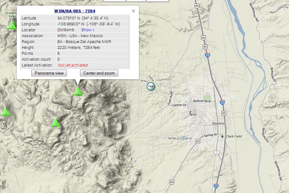
Upcoming SOTA Activation of W5N/BA-005 on 20 July
If you’re coming from sotawatch.org, welcome!
—Details—
Peak: W5N/BA-005 – 7284 [Socorro Peak]
Location: Socorro, NM, DM64mb
Time: 20 July 2013, 1700 UTC
Bands: anything I can manage. Likely 20m and up, and 2m
Mode: SSB preferred, but I want to try to muddle through some CW. I’ve never done CW without a computer (shame on me) so PSE QRS!
On 20 July, I plan to activate a nearby mountain for SOTA. This isn’t any regular mountain – the some parts of the road up to the peak is owned by EMRTC, or, simply speaking, its a bombing range. Therefore access is permit-only and this plan is tentative at the moment [edit — It’s a go!!]. However, at last night’s Socorro ham club meeting, I met a guy willing to be my escort, so I don’t get blown up, and to make sure I don’t steal anything, I suppose.
 |
| Map of the area and the Summit. [http://sotamaps.wsstvc.org/] |
BA-005 is known as 7284 on the SOTA map, but the peak is commonly referred to as M-Mountain or Socorro Peak. A nearby peak which has a large, limestone M on it isn’t included in the database because it’s too near the taller peak.They only differ in elevation by about 60 feet.
This shorter peak is the home of the famous Elfego Baca Golf Shoot, where participants tee off at about 1500ft above and 2 miles awaythe hole. I think it’s a par 36 😀
Instead of golf, we’re going to shoot for some QSOs.
I’ll be using my new fangled End Fed Half Wave coupler and some conveniently placed towers. If those don’t work, then I’ll revert to some hamsticks. Stay tuned for more on the antenna project, and the summaryof the activation!
Activation Alert: WØ/FR-003 (Mount Evans) –4347m / 14,264ft
Date: 3 July 2012
Time: Approx. 1700 UTC – 1800 UTC
Region: CO-Front Range
Elevation: 4337 m / 14,264 ft – 10 Points
Call Sign: KDØBIK
Frequencies: 14.342.5-ssb, 18.157.5-ssb, +/- 146.52-fm
Equipment: Elecraft KX3 (2nd activation / Buddipole versatee vertical
APRS Track: On Road / On Trail
My wife and I are on a staycation (vacation at home) this week and while I’ve spent some time working on the new basement ham shack, I also wanted to take a much needed break and go and explore a portion of Colorado I’ve never had the opportunity.
Mount Evans is very near I-70, I’ve driven past many times and I can see it from my office building in the Denver Tech Center. It is much like Pikes Peak in the sense that there is a paved road almost all the way to the top. I’m going to take my wife along for this SOTA adventure. We’ll drive to the top and I’ll hike down far enough and then back up to call it a legal SOTA activation and hopefully make a few HF contacts and take in the beauty of Colorado. We’ll then probably go to lunch in Idaho Springs. Perhaps Beau Jo’s Pizza.
Please listen for me on 20m around 1700 UTC (11 AM MT). I look forward to working you.
By the way. My Grandfather’s family name (and my Mom’s maiden name is Evans). I’ll be dedicating this SOTA activation in my Grandfather’s memory. If successful, this will be the first SOTA activation on Mount Evans.
Until next time….
73 de KD0BIK
Activation Alert: WØ/FR-185 (Centennial Cone) –2640m / 8661ft
Date: 21 April 2012
Time: Approx. 1600 UTC – 1800 UTC
Region: CO-Front Range
Elevation: 2640 m / 8661 ft – 2 Points
Call Sign: KDØBIK
Frequencies: 14.342.5-ssb, 18.157.5-ssb, 28.327.5-ssb, +/- 146.52-fm
I may also try PSK31 on 20m (14.070)
Equipment: Elecraft KX3 (maiden activation / Buddipole versatee vertical
APRS Track: On Road / On Trail
The more I played around with my brand new (less than 48 hour old) Elecraft KX3, the more I knew I had to plan an activation for this weekend. This will mean I’ll probably miss the combined QRPTTF + SOTA event scheduled for Saturday, 28 April.

Centennial Cone is a two point SOTA summit and is located just slightly NW from Genesee Mountain (WØ/FR-194) that I activated just a few weeks ago. At the present time Centennial Cone has had no other activations. So this will be my second summit where I was the first to activate.
I’m going to setup and operate on 20m SSB. However, I may also attempt to operate PSK31 via my iPad and the PSKer iOS App.
Well I need to wrap this up as I need to double check my gear and get it all ready to go. I look forward to working you on my fourth SOTA activation.
73 de KDØBIK


