Archive for the ‘hamfest’ Category
 Let’s Call CQ – QSO Today Episode 184 with NW7US
I got a Skype call a few weeks ago from Eric, 4Z1UG–the creator and host of the QSO Today Podcast–during which he asked me about how and why I got into amateur radio. Here’s the result.
Eric writes,
We talk a lot about the band conditions due to the Sunspot cycle. Most of it on Facebook and other places is about how “dead” the bands are at this point. We all can’t wait until the cycle starts to rise and we will be making contacts with little effort. I remember in my conversation with Chuck Adams, K7QO in Episode 58, that he really enjoys operating is “Pigrig”, one watt, CW transceiver on 20 meters. When I asked him, (I liberally paraphrase) “but Chuck, the bands are dead. How does that work for you?”. His reply was that while most hams are listening to the bands, he calls CQ until he gets a reply. Works every time.
My QSO this week is with Tomas Hood, NW7US, who has years of expertise in propagation and Solar activity. He is the propagation editor of more than a few radio magazines and websites. In our post-recording conversation we discussed this phenomenon of listening and not calling CQ. I even had this idea that maybe one of the reasons that the digital modes are so successful is because they “beacon”, as part of the whole digital experience, the same as calling CQ. This is why they make contacts. From what I see, looking at PSK Reporter, hams are making lots of contacts worldwide using the digital modes. While SSB may not be working so well, CW and the digital modes seem to work fine.
I like to work on my bench or make the podcast while listening to the bands. Jeff Damm, WA7MLH, in Episode 177, says that he will put his keyer in CQ mode while he is working on a new radio. Invariably, sometimes after many minutes, he gets a reply. Great idea Jeff!
73,
Eric, 4Z1UG
Episode 184 can be found here: https://www.qsotoday.com/podcasts/nw7us
Highlights of Episode 184:
Tomas Hood, NW7US is the propagation editor of a number of shortwave and amateur radio magazines, and has a wide variety of websites, that grew out of his love for all things radio, and for listening on the bands to far off DX and commercial broadcast stations. Tomas shares his understanding of propagation and the lessons we can learn from listening, really listening to the QSOs and exchanges during contest operation.
All of the QSO Today episodes are great. I enjoy hearing about many different hams. Do check out all of the episodes that Eric has published.
73 de NW7US dit dit
ETH096 – School Club Roundup, Hamvention Update and More…Everything Ham Radio
Hello everybody! In this episode of the Everything Ham Radio Podcast, I am stuck by myself talk to yall. I unfortunately didn’t remember that I my next scheduled update was due until 4pm the day before. So I worked all afternoon, while at work, trying to figure out what I was going to talk about. When I got off work at midnight, I ran home and did my couple honey-dos and then went straight to recording the episode.
So what is in this episode?
First off, I made a mistake! Yea, I know, nobody is suppose to make mistakes right? Well, in my last episode I did. In last episode, my semi regular co-host Ian KM4IK and were talking about the big stink that was doing on with some things that the ARRL Board of Directors were going to be voting on. Neither one of us were really up to speed on the whole thing as much as we should be, but we did our best, and we even said that we weren’t. However, after the episode I did receive multiple emails saying that I said something wrong, so I corrected it in this episode.
With that out of the way, I went on to talk about an upcoming event called the School Club Roundup. It is this month only a few days away actually. The event run February 12-16, 2018. It is an event that is geared for school amateur radio clubs to get on the air and make some contacts. Even if you are not in a school club though you can still get on the air and make contact with the school clubs that are on the air and help them make the points.
After that, I moved on to Hamvention. Another correction from last episode. Well I say correction, this time it wasn’t me though. In last episode we talked about how a new building was going to be built and available by this Hamvention. However, this week, the Hamvention committee released that it wouldn’t be started on until later in the year due to a material shortage.
I wrap up the episode reading some emails that I have received over the past few weeks. The last episode of 2017, I told yall what my plans were for 2018 and asked what some of yalls were and also asked some questions about what were yalls opinions on how my show is. I got a few responses, wish I would’ve had more though.
Until Next Time Yall…
73 de Curtis, K5CLM
Kickin It With the HR360 Workbench Crew – ETH077

If any of yall listen to the Hamradio 360: Workbench podcast then you will know the names George and Jeremy. They are the host of that podcast and some good friends of mine. Several episodes ago they talked about some miniature data radios and some uses for them. I had some questions about it so I thought what better than to do that to come on and talk about them on an episode so that yall can hear them too.
I got all my questions answered, Thanks George!
We went on to talk about their podcast and things that they had been doing and even an upcoming show topic and then wrapped it up with their thoughts on how Hamvention was this year and what they thought about the new venue.
I think we had a great conversation and I hope yall do to.
Check out the show notes for information about the episode, links to all the items that we talked about and other information. You can also listen to the episode directly on the website or on your favorite podcast listening app.
Hamvention Is Here – ETH069
With Hamvention already on top of us, I figured I’d throw my two cents worth into the mix with everybody else’s. In this episode of the Everything Ham Radio Podcast, we talk about some of the interesting things that are going to be going on at this years Hamvention at it’s new location in Xenia, OH.
DARA teamed up with The Miami Valley Mesh Alliance (MVMA) to setup a Mesh network on channel -2 at 10 MHz bandwidth. The SSID is AREDN-10-v3.
We talk about all of my fellow podcasters/youtubers that are there and what they have going on and where they are at.
Lastly, we discussed some of the interesting forum topics that are going on during the weekend. To listen to the episode as well as check out all the links and further information on the topic, check out the show notes at:
ETH068 – Are You Weather Aware?

Photo by Curtis Mohr, K5CLM
While having access to your local RADAR wherever you are is great, you shouldn’t depend on it totally. You should be able to look at the sky, feel the wind, and see other clues to have an idea of what could be coming your way.
This brings up the question:
Are You Weather Aware?
In episode 68, we talk about this question and some things that you need to learn and do to help yourself be weather aware. Things like knowing what to look for in the clouds, why the wind suddenly changed directions, what to have in your emergency kit and having a plan with your family in case you need to vacate your home or seek shelter inside.
We dive into several weather events like tornadoes, flash floods, hail and even the event with the highest average of fatalities, which might surprise you.
We talk about W5KUB with the Amateur Radio Roundtable as he does his Hamvention coverage including the drive to and from. We also talk about some other hamfests that are coming up over the next two weeks.
If contesting is you thing, we talk about all the upcoming contests/on-the-air events for the next two weeks as well.
Check out the show notes and listen to the episode at:
LHS Episode #165: Knifey Spoony
 We're back at it again, producing podcasts, drinking, laughing, having way too much fun. We hope you do at least a couple of those things when you listen to the show. This time around the topics include the UK selling spectrum, a California university ham factory, cartoons, a Debian Summer of Code project, tax reimbursement for FOSS developers, Firefox Servo, upcoming hamfests and a whole lot more. Thanks for tuning in--and please don't forget our LHS Hamvention 2016 Generosity Campaign campaign. Hamvention 2016 is less than two months away.
73 de The LHS Crew
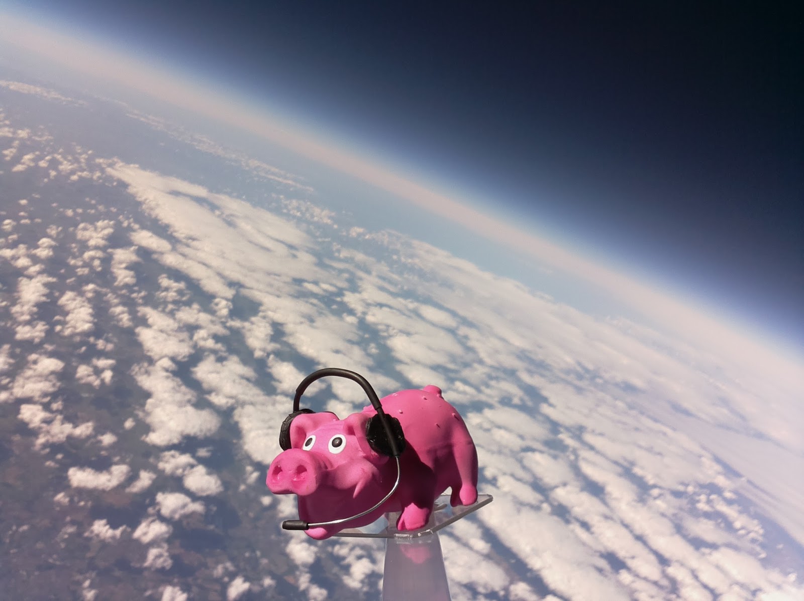
Hamfest Balloon – Some analysis
I contacted some local and national newspapers about the flight but with little response. The Register IT news website did put an article on http://www.theregister.co.uk/2015/09/28/pigs_in_spaaaace
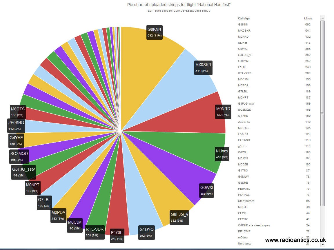
I checked out the telemetry statistics on http://habitat.habhub.org/stats/ and was impressed with the number of people who tracked (as can be seen in the pie chart below) I know that several interested parties have since visited the UKHAS wiki and have been asking questions on the IRC channel on how to do a flight and/or develop their own trackers. Naturally I have also been thinking about some possible future flights.
While the novelty of flying something into space, be it a toy pig or an egg is satisfying I would like to make any future flight serve some purpose, whether collecting more data or ideally doing some experiment with radio even if it within the constraints of the UK draconian regulations when operating in the air!
One set of data I did extract was the temperature profile during the flight. PINKY had two sensors, one internal to the Styrofoam box, the other external. PIGLET also had a temperature/pressure sensor but it was giving odd readings during the flight so have ignored that.
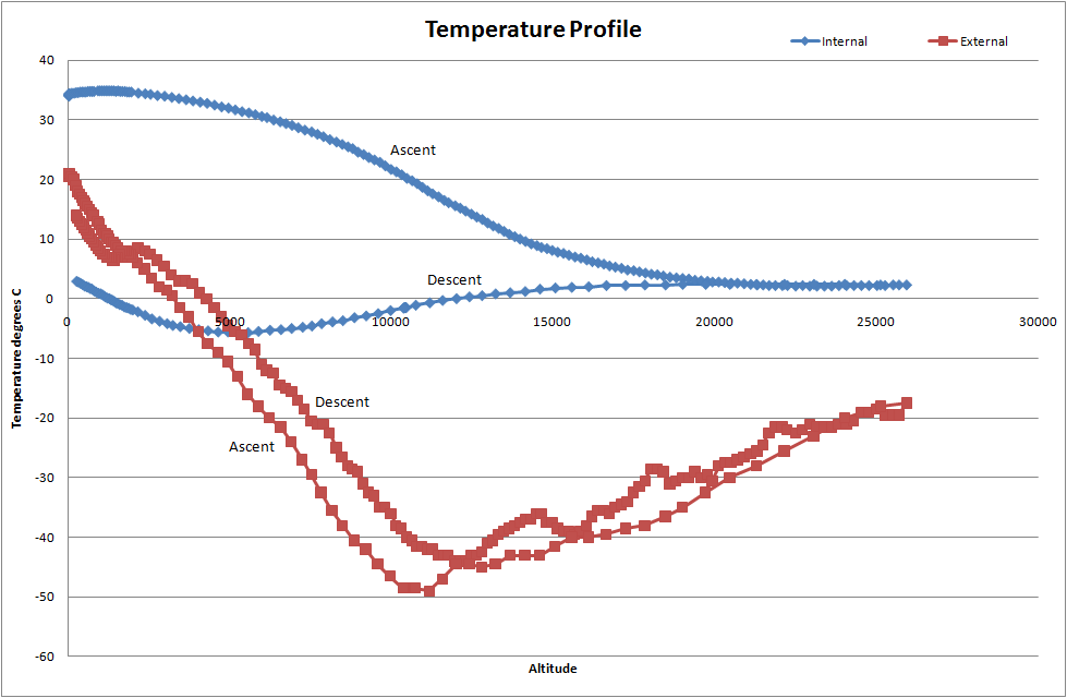
The graph shows internal/external temperature recorded by PINKY against altitude, there are two plots for each showing the ascent profile and the decent. The lowest temperature recorded by the external temperature was -49.5°C (-57.1°F) and the foam did a good job of insulating the internal electronics, though it drop below 0°C during the decent.
One thing I will do on the next flight (if it happens) is take a lot more photographs, using a 32GB memory card I could have held a lot more images. Also I will look at embedding the GPS coordinates (geotagging) into the image files.
I will also put on board a video camera, I did purchase a cheap dash cam type for £20 one off eBay for the Eggsplorer-1 but didn't use it because of sea-landing, I need to sort out powering it as the internal battery wouldn't last for the duration of the flight.
I have still to investigate the issues with the LoRa as to why it failed. This weekend Dave Akerman is flying three balloons in succession with LoRa tracker modules. They will be set up to work in a mesh, receiving and repeat each others telemetry. Sounds an interesting experiment, I will have to set my LoRa gateway back up and attempt to receive them.