Archive for the ‘ham radio’ Category
 Another Black Mountain SOTA (W0C/FR-031)
There are (at least) 20 different summits named “Black Mountain” just in the state of Colorado. I’m sure there are many more nationwide. It seems to be a popular, if unimaginative, name. This is why we have a numbering system for Summits On The Air, else we would forever be talking about “which Black Mountain was that anyway?” Or Deer Peak or Sheep Mountain or …
On Thursday, Joyce K0JJW and I activated another Black Mountain, this one with Summits On The Air (SOTA) designator: W0C/FR-031. I’m not sure why it has an FR or Front Range designation, as the summit is actually in the South Park region of the state. I can tell you that it is an awesome summit with great views.
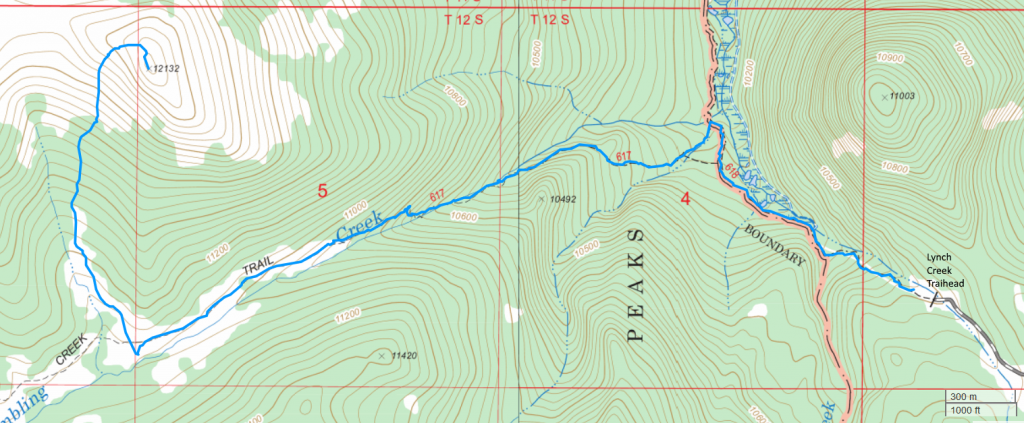
To get to Black Mountain, take Highway 9 south out of Hartsel, CO (or come north on Highway 9 from the south). The Pike National Forest map is very helpful with getting into the vicinity of the mountain. Turn west on FS 108. (This is the same road that leads to Dicks Peak W0C/FR-041.) This road has a sign that indicated “Dicks Peak” and “Black Mountain”. Follow FS 108 S/SW and then take FS 107 to the south (right turn). Follow FS 107 to FS 268, then follow FS 268. About this time, you should have an excellent view of Black Mountain to the south. The roads were muddy and rutted, definitely 4WD. Our Jeep Wrangler had no problem but a AWD crossover/Subaru may be challenged to get through.
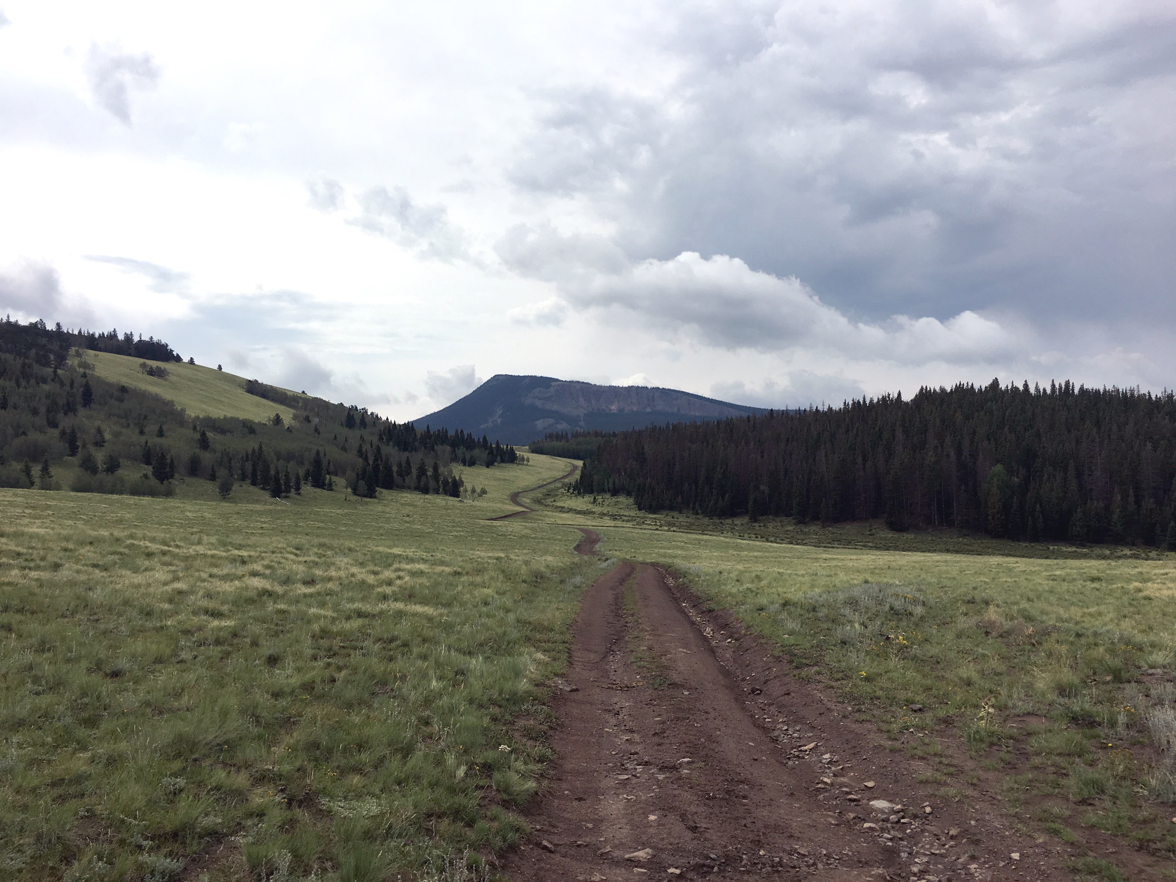
Black Mountain has a steep vertical rock face to the north, which is very visible. At this point, we wondered if we signed up for a difficult climb…but not so. FS 268 turns west, kind of parallel to Black Mountain, then heads away from it. At this point, we wondered if we were on the wrong road. Not so. At this point, the Pike National Forest map failed us…it seems to be incomplete in this area. Instead we used the gaiagps.com app on my smartphone which had a representation of the terrain and roads. As we headed west on FS 268 we saw a road heading off to the south. (I don’t recall if it is marked, but see map below.) Take this road south for about one and a half miles…looking for an unmarked road heading off to the east. The intersection with this road is easy to miss as it is not that distinct. But the road is very visible heading off to the east, so you’ll probably spot it later if you miss the turn and can circle back.
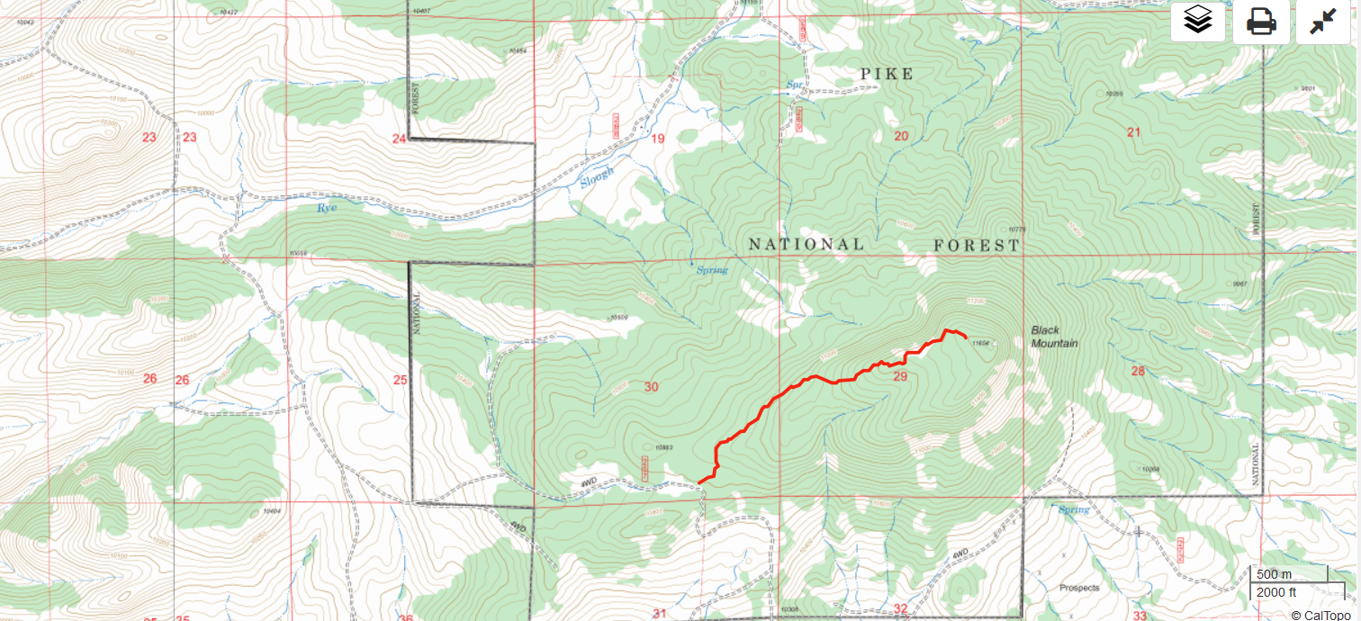
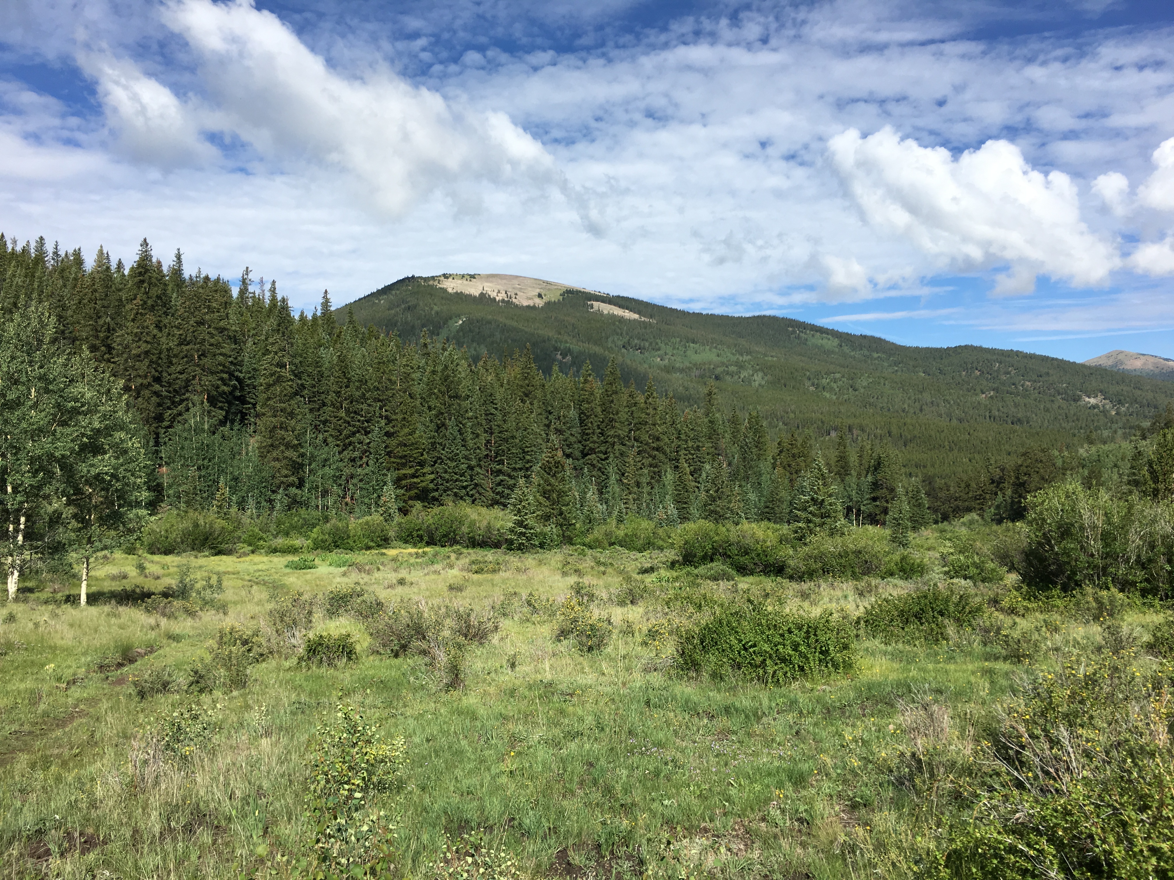
We took the unmarked road east until it deadended at a camping spot. We parked there and started the climb up to the summit. There are only random bits of a trail here and there, so we mostly just followed the GPS towards the summit. The route is forested with some downed timber but not difficult to navigate. The steep north side of Black Mountain provided some nice views. The hike is about 1.5 miles and 1000 feet vertical.
On top, we worked stations on 2m and 70cm fm without much trouble. It is an excellent VHF/UHF site and we found a number of locals hanging out on 146.52 MHz. We reversed our route on the way down and drove the Jeep out.
W0C/FR-222
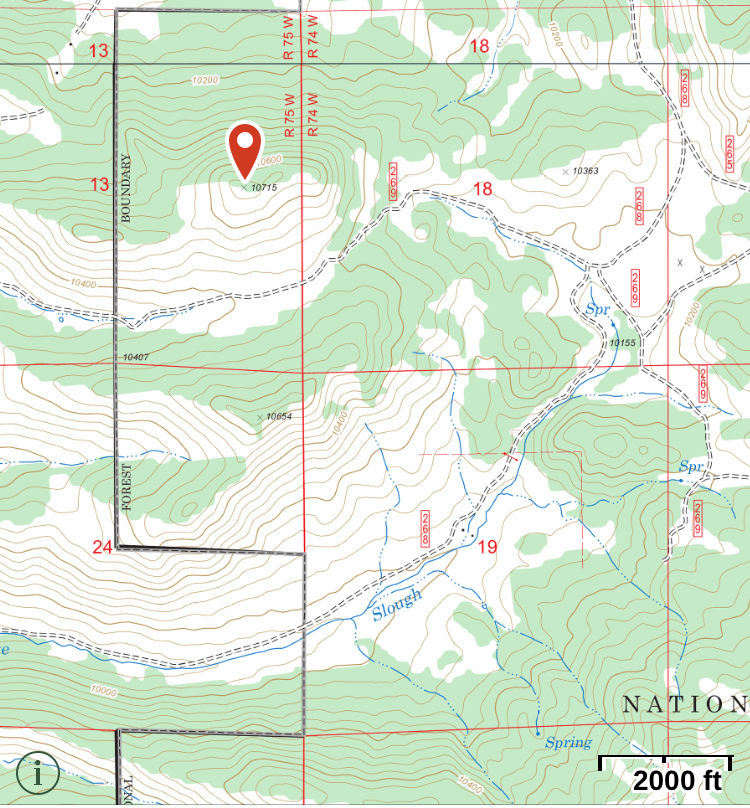
Steve WG0AT suggested that we could do an nearby unnamed peak (W0C/FR-222) on the same day. This is an excellent idea and we did just that. We headed back north and took FS 269 west, parking just south of FR-222. FR-222 is not shown on the Pike National Forest map but the Gaiagps.com app and other maps show it. The summit is easily seen from the road and a short hike gets you to the top (about 1/3 mile and 500 vertical feet).
73, Bob K0NR
The post Another Black Mountain SOTA (W0C/FR-031) appeared first on The KØNR Radio Site.
Amateur TV with Tom O’Hara, W6ORG – ETH080

Have you ever wanted to be in a movie? Or maybe on TV? Well while you can make your own movie and you could be on a TV, you probably won’t be on commercial TV. However you can be on Amateur TV.
In this episode I talk with Tom O’Hara, W6ORG. Tom has been a ham for a while and had a successful ATV business for over 50 years!! He retired and shut his business down at the end of 2014, but that hasn’t stopped him from working with Amateur TV!
Listen to this episode to find out more about Amateur TV and about Tom:
Old, But Still Useful!
This old WWII military training video is still useful regarding Morse code:
[embedyt]https://www.youtube.com/watch?v=YqTn-165orw[/embedyt]
This is an antique United States Navy Training Film from 1943/1944, in which proper hand-sending of Morse code is demonstrated. The film covers some basic principles and mechanics of manual keying of the International Morse code, as used during WWII.
Amateur (Ham) radio operators find Morse code (and the ‘CW’ mode, or ‘Continuous Wave’ keying mode) very useful, even though Morse code is no longer required as part of the licensing process. Morse code is highly effective in weak-signal radio work. And, preppers love Morse code because it is the most efficient way to communicate when there is a major disaster that could wipe out the communications infrastructure.
While this military film is antique, the vintage information is timeless, as the material is applicable to Morse code, even today.
There’s more about Morse code, at my website: http://cw.hfradio.org
For additional joy, here are a few of old films regarding Morse code:
Morse Code – Principles and Basic Techniques (US Army Signal)
(Learn to Send Perfect Morse Code by Hand – Vintage Training Film (Ham Radio / CW))
[embedyt]https://www.youtube.com/watch?v=qmg1MlstxWM[/embedyt]
Vintage 1944 Radio Operator Training: How to Send Morse Code (CW) by Hand
[embedyt]https://www.youtube.com/watch?v=XjupJslRj5E[/embedyt]
This one is a pretty cool film:
1939 Film: New Zealand Shortwave Communications; Morse code (CW)
[embedyt]https://www.youtube.com/watch?v=H-KUat5WEkU[/embedyt]
I’ve also created a play list, and most of the videos are still online. Once and a while something changes and I have to update the list. Here is the list:
Original Title: TECHNIQUE OF HAND SENDING, by Department of Defense, Published 1944
Usage CC0 1.0 Universal
TECHNIQUE OF HAND SENDING
PIN 23735 1944
IMPORTANT PARTS OF THE TRANSMITTER, TENSION SPRING, ADJUSTING CONTACTS, ADJUSTING SPRINGS. ELEMENTS OF MORSE CODE, TIMING, AND PARTS OF BODY THAT FUNCTION WHEN TRANSMITTING CODE. IMPORTANCE OF CORRECT POSITION AND OPERATION.
Producer Department of Defense
Enjoy!
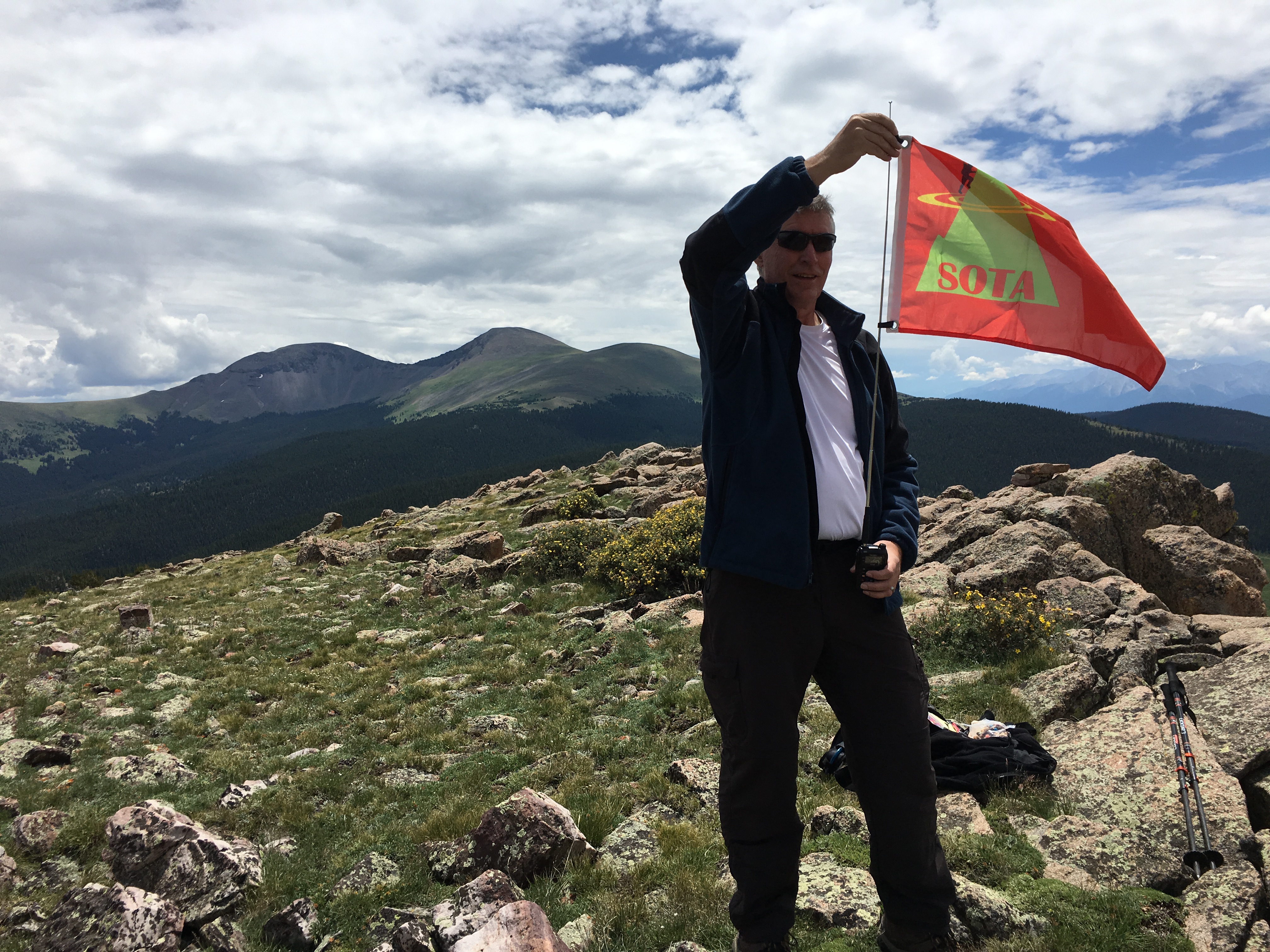
First SOTA Activation for W0C/SP-055
For several years, I’ve had my eye on an unnamed summit (12132) in the Buffalo Peaks Wilderness Area (W0C/SP-055). No one had activated it for Summits On The Air (SOTA) probably because the summit is somewhat remote. I originally thought I would have to do many miles of bushwhacking from the north to get to get to the top. After studying a few maps and trail descriptions, I eventually found a route from the east that is not too difficult.
My hiking partner Joyce/K0JJW and I started at Lynch Creek Trailhead, which is about 9 miles west of Highway 285 on FS 431, also known as Buffalo Peaks Road. The USFS Pike National Forest map is a good reference for finding the trailhead. We followed Salt Creek Trail #618 for about 1 mile to connect to the Tumble Creek Trail #617. These are well-used and well-maintained trails and a joy to walk on. We had been doing too much off-trail hiking lately, so this was a very nice change. The trails are marked by signs at the junction and are easy to follow.
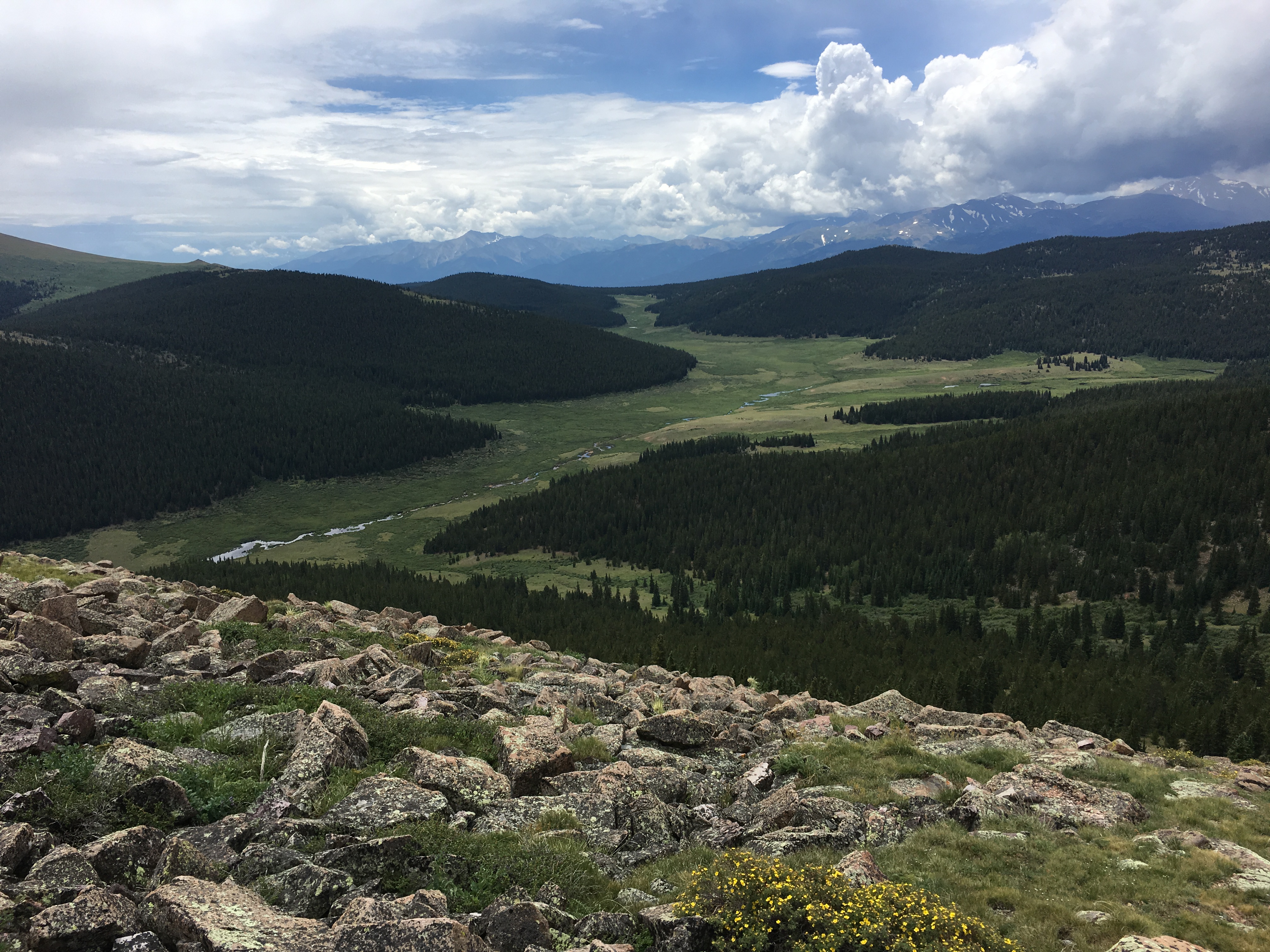
We considered ascending the east side of the mountain but concluded that we’d end up hiking through some dense forest, which usually means downed timber and slow progress. Instead, we approached the summit from the south, leaving Trail 617 about three miles in from the trailhead, and heading uphill through a grassy meadow. There is a large beaver pond to the south at the point where we left the trail, so that makes for a good landmark. You can’t completely avoid the trees on this path but they are sparse enough to easily walk through. Near the summit, the easiest path hooks around to approach the summit from the west, avoiding some steep rocks on the south side of the summit. (Actually, we went straight up the rocks on the ascent and decided to avoid them on the descent.)
The summit is above treeline and relatively flat, offering excellent views in all directions.
Joyce and I both got on the air and made calls on 146.52 and 446.00 MHz using handheld VHF/UHF radios. We just used vertical antennas and didn’t bother to assemble the yagi antennas. Thanks to these stations that we worked that day: W0BV, W0DLE, N0VXE, K0RCW, K9LNH and KD0VHD.
The GPS app on my smartphone indicated the one-way distance at just under 4 miles, with an elevation gain of 2000 feet. The actual elevation gain may be slightly more than that due to some ups and downs on the trail. This is one of those hikes that we’ll probably do again in the future. It has an enjoyable mix of good trails, rolling streams, green meadows, great views and a pleasant summit.
73, Bob K0NR
The post First SOTA Activation for W0C/SP-055 appeared first on The KØNR Radio Site.
System Fusion DR-2X Repeater, Solar Eclipse and More – ETH079

In this episode we talk about the Yaesu System Fusion DR-2X repeater, the upcoming Solar Eclipse and more.
There is some interesting new features on the DR-2X repeater over the DR-1X that came out a couple years ago, but there is also something that it doesn’t have. Some of these features, I wish that we had on our club repeater, but those features are not enough for us to go out and buy this version.
There are a lot of special event stations that are going to be on the air around August 21st this year when the full solar eclipse occurs. This is the first time since 1918 that a full solar eclipse has gone from one side of the US to the other. I unfortunately am to far south to the see the full eclipse, but I should get about a 75% one here in the DFW area.
We also talk about some other stuff, but you are going to have to check out the show notes and listen to the episode to find out what that is.
73s de Curtis, K5CLM
RepeaterBook – A FREE Online Repeater Directory – ETH078

In this episode of the Everything Ham Radio Podcast, we talk with Garrett Dow, KD6KPC, the creator of RepeaterBook.com. RepeaterBook is a free online repeater directory that covers all of the US and Canada as well as several other countries around the world.
You can use RepeaterBook directly from its website, or through its app. You can find the app on IOS, Android and Kindle. RepeaterBook has done a great job on getting and maintaining the information of about 35,000 repeaters thank in a large part to about 95 admins that maintain the records in their assigned areas and from the ham community at large.
Make sure you give the interview a listen and check out the show notes.
Kickin It With the HR360 Workbench Crew – ETH077

If any of yall listen to the Hamradio 360: Workbench podcast then you will know the names George and Jeremy. They are the host of that podcast and some good friends of mine. Several episodes ago they talked about some miniature data radios and some uses for them. I had some questions about it so I thought what better than to do that to come on and talk about them on an episode so that yall can hear them too.
I got all my questions answered, Thanks George!
We went on to talk about their podcast and things that they had been doing and even an upcoming show topic and then wrapped it up with their thoughts on how Hamvention was this year and what they thought about the new venue.
I think we had a great conversation and I hope yall do to.
Check out the show notes for information about the episode, links to all the items that we talked about and other information. You can also listen to the episode directly on the website or on your favorite podcast listening app.


