Author Archive
 ARISS 20th Anniversary SSTV
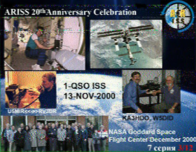
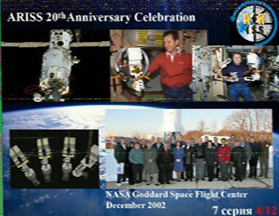
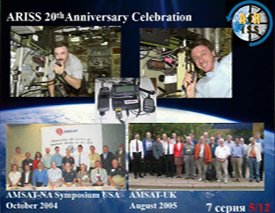
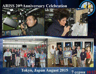
This weekend has seen another SSTV event from the International Space Station, this time in commemoration of the 20th Anniversary of ARISS (Amateur Radio on the International Space Station)
The 20 year history of ARISS was displayed through a collection of 12 images highlighting the accomplishments of the project over the last two decades.
As the ISS has orbited the world it has been transmitting the SSTV signals using FM on the usual downlink of 145.800 MHz, here at my QTH in the UK the passes have occurred late at night into the early morning, averaging 3 - 4 reasonable passes each day.
The signal has been very strong and so some excellent low noise images have been received by many people using just modest equipment. While not the greatest technical achievement in the world it nonetheless generates much needed interest in ARISS and amateur space communication.
My own system consisted of the Yaesu FT-857D and MMSSTV running on the shack PC and was left on automatic receive (I was tucked up in bed) and managed to get decent copies of all the images.
Image 8 reminded me of the fun I had back in 2011-2012 of receiving the ARRISAT-1 and was one of the key things that convinced me to finally get off my backside and actually get licensed, even if it took me another 12 months and to this day haven't really cracked satellites myself! My previous blog posts on that can be found at http://nerdsville.blogspot.co.uk/search/label/arissat-1
Here are the best of my images, for a full description of what each one depicts visit http://ariss-sstv.blogspot.co.uk/2017/07/anniversary-image-descriptions.html


First SOTA activation – Normanby Top G/TW-005
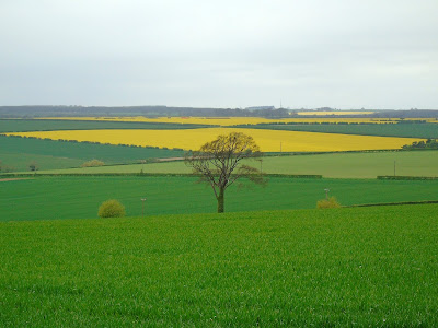
We ventured out to the Lincolnshire Wolds again on Saturday and spent most of the morning taking in a fabulous little 5 mile circular walk from the village of Wold Newton with the wife finding over twenty geocaches along the way.
After last weekends disappointment I had purchased a new Baofeng UV-82L dual band for the princely sum of £27 from eBay to replace the suspect UV-5R. It certainly seems more sensitive when receiving and the transmit audio is loud and clear.
With the 'flower-pot' antenna in the rucksack I spent the walk monitoring the local repeaters (and could hear the regular idents) as well as the calling channels. I was putting out the odd call (with little success) when we stopped to allow the wife to search for the geocaches.
However I wasn't disheartened as the plan was to spend the afternoon on Normanby Top, the highest point on the Lincolnshire Wolds trying to activate the summit for SOTA.
I had been spurned on to have a go at an activation after watching a video of Michael Sansom's (G0POT) presentation on the SOTA scheme for the Chertsey Radio Club. The video is available online here and Michael has written an excellent companion introduction to SOTA on his website http://peanutpower.co.uk/sota
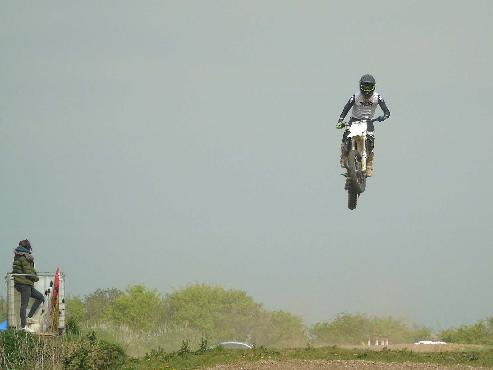
After finishing the walk we drove the short distance stopping to collect more geocaches along the way and as we neared Normanby Top we stumbled across Thoresway Motoparc where they were busy practising their motorbike scrambling skills and I spent a while taking some action photographs from the side of the road.
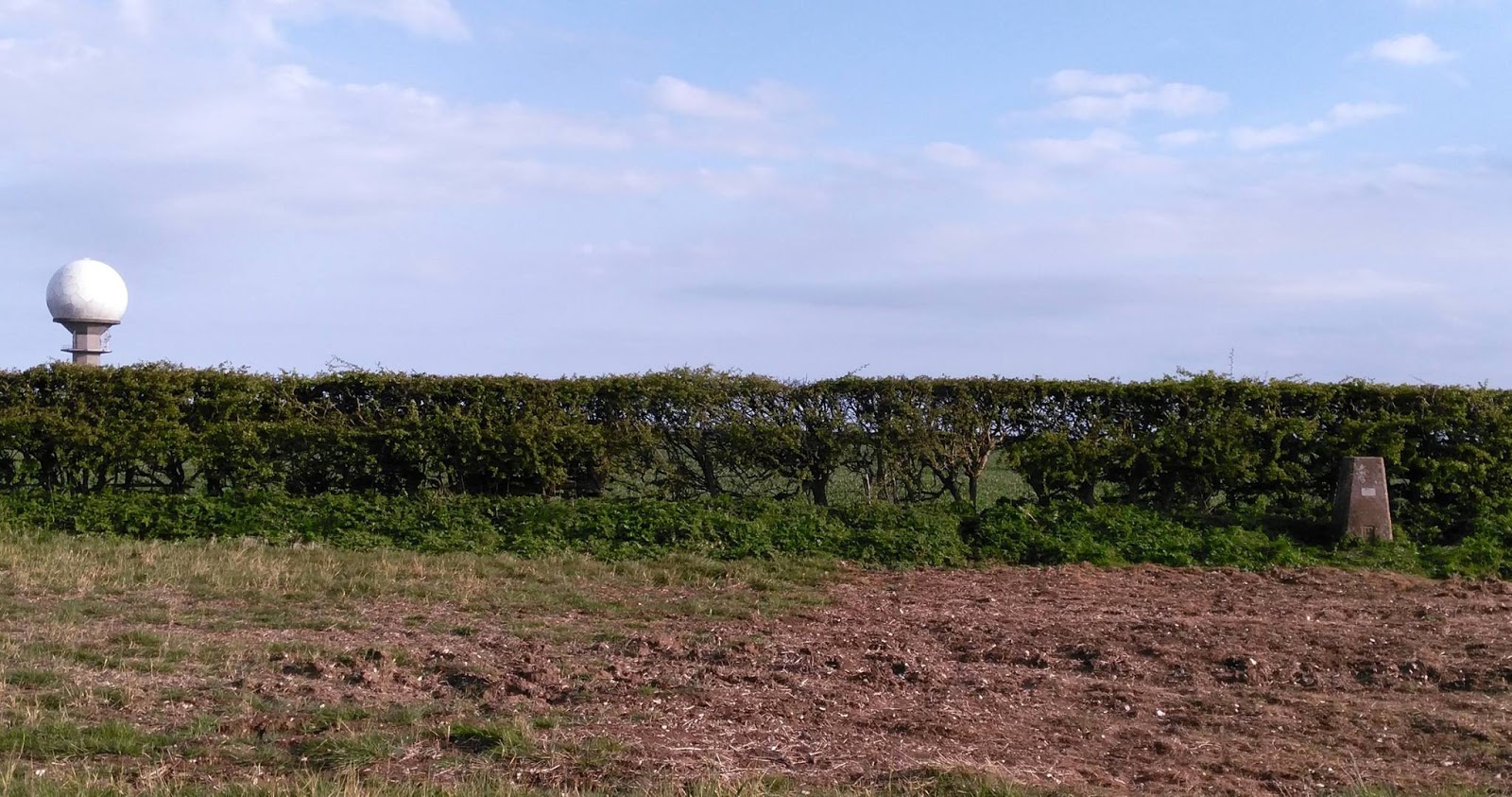
But I digress, Normanby Top, as I've said is the highest point on the Lincolnshire Wolds and the actual summit has an Ordnance Survey triangulation pillar as indicated on the map but it on private land. The SOTA rules allow someone to activate a summit by being within 25m vertically of the high point, this means the activation area for Normanby Top is potentially huge as it is more of a plateau than a steeply defined hill.
To the South of the summit is a road with an air-traffic control radar station. We parked up near this impressive structure to have some very late lunch (time had flown by)
I could have activated from this road as others have done but I decided to use the bridleway to the North which leads off the Viking Way long distance footpath. The wife dropped me off at Acre House Farm and she went off to hunt for yet more geocaches and I set off down the track to find a suitable place to set up. I was a little hampered by the proximity of a power line which followed the bridleway but as luck would have it just as I had finished setting up at my chosen spot the landowner came down the farm track in his Land Rover.
I had a friendly chat with him and he was fully aware of what I was doing and had no issues having met other activators in the past. He also gave me permission to walk across his land up to the trig-point if I wanted to. As I've mentioned it isn't on a public right of way but said he is more than happy for people to go to the trig-point providing they ask at the farm before hand and take home all their rubbish, unfortunately he has some recent problems with inconsiderate litterers.
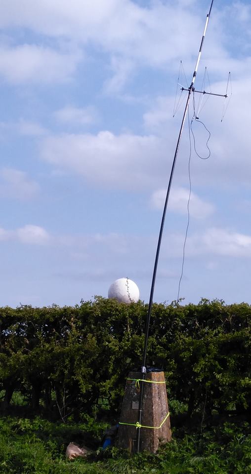
I decided to decamped and following his instructions to a gap in the fence and set off to the trig-point which was a little bit further away and a little steeper than I thought, but it didn't help I was carrying a half made up antenna, poles and a bag full of kit and my not inconsiderate bulk! Anyway I got there but due to us running already behind schedule and my change of location it was getting late in the day and was nearly 5pm.
I had taken my Yaesu FT-857D, two 7Ahr SLA batteries, fibreglass pole, antennas for 20m/40m HF, 2m SSB and 2m/70cm FM. Yes I'd travelled light! Having some lovely clear views all around I decided to try some 2m 'line of sight' contacts.
I put up the Sandpiper Delta Beam for SSB (horizontal) and my 'flower-pot' dual band for FM (vertical) on a fishing pole. The wind had started to pick up and I'd not got any proper bungee cords (doh!) so I lashed it up using guy ropes around the pillar.
The radio was perched on top of the pillar and I put some calls on 2m SSB with no luck and switched to FM with more success. I was using between 5-10W and got nothing exceptional distance wise but racked up 8 very nice clear QSOs to claim an activation. The wife texted me to say she had returned from her searching and was parked up patiently at the farm awaiting my return, not hurrying me by any means. It was now nearly 6pm and the wind was getting up and the temperature was starting to drop. It had been a long day for us and the dogs so I decided to packed up and went back down the hill to the bridleway admiring the view across to the Humber and the Humber crossing.
I really enjoyed myself but wished I'd allowed myself more time, this was in part because it was a late decision in the week to tack the 'summit' on the end of a day out walking and changing my mind to actually go to the summit given the chance but it was nice to do that for my first SOTA but I really need to get the hang of travelling light.
After my last post (which is also syndicated to AmateurRadio.com) I had some questions about Geocaching - Dave, WD8CIV left this useful comment which I shall repeat as summed it succinctly - thanks Dave.
"Geocaching is like a high tech Easter egg hunt. People hide caches – waterproof containers containing a logbook and maybe some little trinkets – and then post the GPS coordinates to a Web site like geocaching.com. Others will search the site for caches in an area of interest, then use their own GPS (and intuition and woodcraft skills) to try to find them. Anyone who finds a cache signs the logbook, may take one of the trinkets and/or leave a new one, then goes back to the Web site and reports that they found that cache. There’s quite a community of geocachers, and it’s been going on for over a decade."

After last weekends disappointment I had purchased a new Baofeng UV-82L dual band for the princely sum of £27 from eBay to replace the suspect UV-5R. It certainly seems more sensitive when receiving and the transmit audio is loud and clear.
With the 'flower-pot' antenna in the rucksack I spent the walk monitoring the local repeaters (and could hear the regular idents) as well as the calling channels. I was putting out the odd call (with little success) when we stopped to allow the wife to search for the geocaches.
 |
| One man and his dogs |
I had been spurned on to have a go at an activation after watching a video of Michael Sansom's (G0POT) presentation on the SOTA scheme for the Chertsey Radio Club. The video is available online here and Michael has written an excellent companion introduction to SOTA on his website http://peanutpower.co.uk/sota
 |
| View across to radar station on Normanby Top |
 |
| Saw some spectacular jumping skills |
 |
| Section of the 1:25000 Ordnance Survey Map |
To the South of the summit is a road with an air-traffic control radar station. We parked up near this impressive structure to have some very late lunch (time had flown by)
 |
| Radar Station on Normanby Top |
I had a friendly chat with him and he was fully aware of what I was doing and had no issues having met other activators in the past. He also gave me permission to walk across his land up to the trig-point if I wanted to. As I've mentioned it isn't on a public right of way but said he is more than happy for people to go to the trig-point providing they ask at the farm before hand and take home all their rubbish, unfortunately he has some recent problems with inconsiderate litterers.
I decided to decamped and following his instructions to a gap in the fence and set off to the trig-point which was a little bit further away and a little steeper than I thought, but it didn't help I was carrying a half made up antenna, poles and a bag full of kit and my not inconsiderate bulk! Anyway I got there but due to us running already behind schedule and my change of location it was getting late in the day and was nearly 5pm.
 |
| Trig-point and radar station behind |
I had taken my Yaesu FT-857D, two 7Ahr SLA batteries, fibreglass pole, antennas for 20m/40m HF, 2m SSB and 2m/70cm FM. Yes I'd travelled light! Having some lovely clear views all around I decided to try some 2m 'line of sight' contacts.
I put up the Sandpiper Delta Beam for SSB (horizontal) and my 'flower-pot' dual band for FM (vertical) on a fishing pole. The wind had started to pick up and I'd not got any proper bungee cords (doh!) so I lashed it up using guy ropes around the pillar.
 | |
| It was straighter than this before I went to take photo |
 |
| View North (Humber to the top left) |
I really enjoyed myself but wished I'd allowed myself more time, this was in part because it was a late decision in the week to tack the 'summit' on the end of a day out walking and changing my mind to actually go to the summit given the chance but it was nice to do that for my first SOTA but I really need to get the hang of travelling light.
 |
| Back down and met by the wife who wanted her shopping bag back |
"Geocaching is like a high tech Easter egg hunt. People hide caches – waterproof containers containing a logbook and maybe some little trinkets – and then post the GPS coordinates to a Web site like geocaching.com. Others will search the site for caches in an area of interest, then use their own GPS (and intuition and woodcraft skills) to try to find them. Anyone who finds a cache signs the logbook, may take one of the trinkets and/or leave a new one, then goes back to the Web site and reports that they found that cache. There’s quite a community of geocachers, and it’s been going on for over a decade."
First SOTA activation – Normanby Top G/TW-005
We ventured out to the Lincolnshire Wolds again on Saturday and spent most of the morning taking in a fabulous little 5 mile circular walk from the village of Wold Newton with the wife finding over twenty geocaches along the way.
After last weekends disappointment I had purchased a new Baofeng UV-82L dual band for the princely sum of £27 from eBay to replace the suspect UV-5R. It certainly seems more sensitive when receiving and the transmit audio is loud and clear.
With the 'flower-pot' antenna in the rucksack I spent the walk monitoring the local repeaters (and could hear the regular idents) as well as the calling channels. I was putting out the odd call (with little success) when we stopped to allow the wife to search for the geocaches.
However I wasn't disheartened as the plan was to spend the afternoon on Normanby Top, the highest point on the Lincolnshire Wolds trying to activate the summit for SOTA.
I had been spurned on to have a go at an activation after watching a video of Michael Sansom's (G0POT) presentation on the SOTA scheme for the Chertsey Radio Club. The video is available online here and Michael has written an excellent companion introduction to SOTA on his website http://peanutpower.co.uk/sota
After finishing the walk we drove the short distance stopping to collect more geocaches along the way and as we neared Normanby Top we stumbled across Thoresway Motoparc where they were busy practising their motorbike scrambling skills and I spent a while taking some action photographs from the side of the road.
But I digress, Normanby Top, as I've said is the highest point on the Lincolnshire Wolds and the actual summit has an Ordnance Survey triangulation pillar as indicated on the map but it on private land. The SOTA rules allow someone to activate a summit by being within 25m vertically of the high point, this means the activation area for Normanby Top is potentially huge as it is more of a plateau than a steeply defined hill.
To the South of the summit is a road with an air-traffic control radar station. We parked up near this impressive structure to have some very late lunch (time had flown by)
I could have activated from this road as others have done but I decided to use the bridleway to the North which leads off the Viking Way long distance footpath. The wife dropped me off at Acre House Farm and she went off to hunt for yet more geocaches and I set off down the track to find a suitable place to set up. I was a little hampered by the proximity of a power line which followed the bridleway but as luck would have it just as I had finished setting up at my chosen spot the landowner came down the farm track in his Land Rover.
I had a friendly chat with him and he was fully aware of what I was doing and had no issues having met other activators in the past. He also gave me permission to walk across his land up to the trig-point if I wanted to. As I've mentioned it isn't on a public right of way but said he is more than happy for people to go to the trig-point providing they ask at the farm before hand and take home all their rubbish, unfortunately he has some recent problems with inconsiderate litterers.
I decided to decamped and following his instructions to a gap in the fence and set off to the trig-point which was a little bit further away and a little steeper than I thought, but it didn't help I was carrying a half made up antenna, poles and a bag full of kit and my not inconsiderate bulk! Anyway I got there but due to us running already behind schedule and my change of location it was getting late in the day and was nearly 5pm.
I had taken my Yaesu FT-857D, two 7Ahr SLA batteries, fibreglass pole, antennas for 20m/40m HF, 2m SSB and 2m/70cm FM. Yes I'd travelled light! Having some lovely clear views all around I decided to try some 2m 'line of sight' contacts.
I put up the Sandpiper Delta Beam for SSB (horizontal) and my 'flower-pot' dual band for FM (vertical) on a fishing pole. The wind had started to pick up and I'd not got any proper bungee cords (doh!) so I lashed it up using guy ropes around the pillar.
The radio was perched on top of the pillar and I put some calls on 2m SSB with no luck and switched to FM with more success. I was using between 5-10W and got nothing exceptional distance wise but racked up 8 very nice clear QSOs to claim an activation. The wife texted me to say she had returned from her searching and was parked up patiently at the farm awaiting my return, not hurrying me by any means. It was now nearly 6pm and the wind was getting up and the temperature was starting to drop. It had been a long day for us and the dogs so I decided to packed up and went back down the hill to the bridleway admiring the view across to the Humber and the Humber crossing.
I really enjoyed myself but wished I'd allowed myself more time, this was in part because it was a late decision in the week to tack the 'summit' on the end of a day out walking and changing my mind to actually go to the summit given the chance but it was nice to do that for my first SOTA but I really need to get the hang of travelling light.
After my last post (which is also syndicated to AmateurRadio.com) I had some questions about Geocaching - Dave, WD8CIV left this useful comment which I shall repeat as summed it succinctly - thanks Dave.
"Geocaching is like a high tech Easter egg hunt. People hide caches – waterproof containers containing a logbook and maybe some little trinkets – and then post the GPS coordinates to a Web site like geocaching.com. Others will search the site for caches in an area of interest, then use their own GPS (and intuition and woodcraft skills) to try to find them. Anyone who finds a cache signs the logbook, may take one of the trinkets and/or leave a new one, then goes back to the Web site and reports that they found that cache. There’s quite a community of geocachers, and it’s been going on for over a decade."
After last weekends disappointment I had purchased a new Baofeng UV-82L dual band for the princely sum of £27 from eBay to replace the suspect UV-5R. It certainly seems more sensitive when receiving and the transmit audio is loud and clear.
With the 'flower-pot' antenna in the rucksack I spent the walk monitoring the local repeaters (and could hear the regular idents) as well as the calling channels. I was putting out the odd call (with little success) when we stopped to allow the wife to search for the geocaches.
|
| One man and his dogs |
I had been spurned on to have a go at an activation after watching a video of Michael Sansom's (G0POT) presentation on the SOTA scheme for the Chertsey Radio Club. The video is available online here and Michael has written an excellent companion introduction to SOTA on his website http://peanutpower.co.uk/sota
|
| View across to radar station on Normanby Top |
|
| Saw some spectacular jumping skills |
|
| Section of the 1:25000 Ordnance Survey Map |
To the South of the summit is a road with an air-traffic control radar station. We parked up near this impressive structure to have some very late lunch (time had flown by)
|
| Radar Station on Normanby Top |
I had a friendly chat with him and he was fully aware of what I was doing and had no issues having met other activators in the past. He also gave me permission to walk across his land up to the trig-point if I wanted to. As I've mentioned it isn't on a public right of way but said he is more than happy for people to go to the trig-point providing they ask at the farm before hand and take home all their rubbish, unfortunately he has some recent problems with inconsiderate litterers.
I decided to decamped and following his instructions to a gap in the fence and set off to the trig-point which was a little bit further away and a little steeper than I thought, but it didn't help I was carrying a half made up antenna, poles and a bag full of kit and my not inconsiderate bulk! Anyway I got there but due to us running already behind schedule and my change of location it was getting late in the day and was nearly 5pm.
|
| Trig-point and radar station behind |
I had taken my Yaesu FT-857D, two 7Ahr SLA batteries, fibreglass pole, antennas for 20m/40m HF, 2m SSB and 2m/70cm FM. Yes I'd travelled light! Having some lovely clear views all around I decided to try some 2m 'line of sight' contacts.
I put up the Sandpiper Delta Beam for SSB (horizontal) and my 'flower-pot' dual band for FM (vertical) on a fishing pole. The wind had started to pick up and I'd not got any proper bungee cords (doh!) so I lashed it up using guy ropes around the pillar.
| |
| It was straighter than this before I went to take photo |
|
| View North (Humber to the top left) |
I really enjoyed myself but wished I'd allowed myself more time, this was in part because it was a late decision in the week to tack the 'summit' on the end of a day out walking and changing my mind to actually go to the summit given the chance but it was nice to do that for my first SOTA but I really need to get the hang of travelling light.
|
| Back down and met by the wife who wanted her shopping bag back |
"Geocaching is like a high tech Easter egg hunt. People hide caches – waterproof containers containing a logbook and maybe some little trinkets – and then post the GPS coordinates to a Web site like geocaching.com. Others will search the site for caches in an area of interest, then use their own GPS (and intuition and woodcraft skills) to try to find them. Anyone who finds a cache signs the logbook, may take one of the trinkets and/or leave a new one, then goes back to the Web site and reports that they found that cache. There’s quite a community of geocachers, and it’s been going on for over a decade."
Out portable on the Lincolnshire Wolds
This Easter weekend we decided to go out with the dogs and combine three hobbies, walking, geocaching and amateur radio whilst taking the opportunity to visit some radio related relics of World War II and the Cold War on the Lincolnshire Wolds.
Following a recent presentation at the South Kesteven ARS by David Gordon G6ENN where he talked about his successful portable operating I was encouraged to constructed a simple dual band 'flower pot' antenna (design from VK2ZOI) using some RG58 coax and 25mm conduit.
My previous attempts at portable operating have largely involved HF and slightly heavy equipment (my Yaesu FT-857D and Sealed Lead Acid batteries) but I decided this time to try VHF/UHF as we were going to one of the highest spots in the area. This allowed me to travel light just taking along a Baofeng UV-5R and the antenna sticking out of the rucksack.
Parking up in Donington on Bain we had a short 4 mile circular walk planned allowing the wife to collect a dozen geocaches along the way with a short detour at the top to visit RAF Stenigot. The walk climbs to the top of a hill, but it isn't a long ascent by any means or overly strenuous. The view back included the impressive Belmont Transmission Tower (just visible over my shoulder in the picture above) which before it was shortened in 2010 was reputably the tallest structure of its type in the world.
The Lincolnshire Wolds is the highest area on the East of England between Yorkshire and Kent and so there are many structures that take advantage of the elevation. In addition to Belmont we could see the Radar station at Wolds Top/Normanby Hill and Lincoln Cathedral in the distance, but we were interested in what was in front of us the remains of RAF Stenigot.
RAF Stenigot was part of the Chain Home radar network during World War II, this early system used large antenna arrays suspended from large towers, one of which is now preserved as a Grade II listed structure which is still used by RAF Aerial Erector School for selection tests for possible recruits.
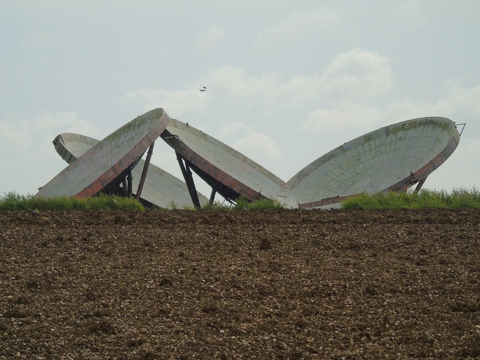
After the Second World War, the site was retained and in 1959 it was upgraded to a communications relay site as part of the NATO ACE High system, which involved adding four tropospheric scatter dishes. The site was decommissioned in the late 1980s and was mostly demolished by 1996 but the toppled dishes remain.
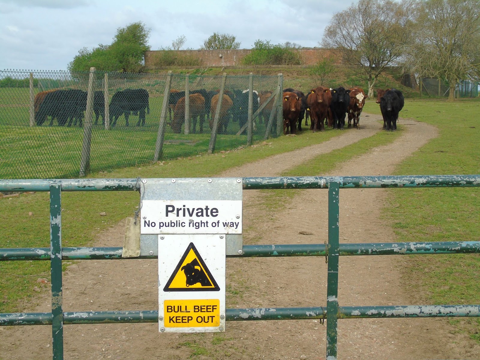
While on private land with no public right of way it is a simple matter to follow the field edge to get quite close, the actual site has been secured to prevent vandalism and is now home to a herd of bulls to deter trespassers!
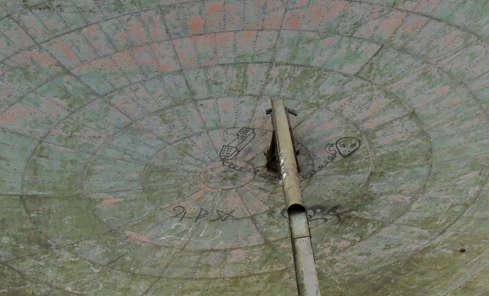
We stopped in the shadow of the dishes for a drink and some refreshment and I got out the radio and attempted to make some contacts, but sadly it seemed like everyone was in still in bed. I could open quite a few nearby repeaters and put out calls but again nothing heard, hopefully ET had better luck!
Checking the equipment when I got home it seems the Baofeng radio has developed quiet TX audio, so it is likely people couldn't hear me. I haven't used these cheap radios much and know they are prone to issues but thought mine was okay. Oh well, at least I looked the part and got a few odd glances from the few walkers and locals we saw. What I didn't realise at the time is the hill is also the site of GB3LC but I did spot some amateur radio antennas nearby.
It really was a great morning walk in a part of the country which is on our doorstep but haven't really visited before. Getting up close to the dishes and the Radar mast was fascinating.
What's more you aren't far from the Lincolnshire Coast, so after our walk we went to Mablethorpe for the afternoon and fish and chips which were well received.
Might look at activating Wolds Top in the near future as it is also a SOTA summit!
Following a recent presentation at the South Kesteven ARS by David Gordon G6ENN where he talked about his successful portable operating I was encouraged to constructed a simple dual band 'flower pot' antenna (design from VK2ZOI) using some RG58 coax and 25mm conduit.
 | |
| Completed 2m/70cm Flower Pot |
My previous attempts at portable operating have largely involved HF and slightly heavy equipment (my Yaesu FT-857D and Sealed Lead Acid batteries) but I decided this time to try VHF/UHF as we were going to one of the highest spots in the area. This allowed me to travel light just taking along a Baofeng UV-5R and the antenna sticking out of the rucksack.
 |
| Just setting off with Boris & Eddie |
Parking up in Donington on Bain we had a short 4 mile circular walk planned allowing the wife to collect a dozen geocaches along the way with a short detour at the top to visit RAF Stenigot. The walk climbs to the top of a hill, but it isn't a long ascent by any means or overly strenuous. The view back included the impressive Belmont Transmission Tower (just visible over my shoulder in the picture above) which before it was shortened in 2010 was reputably the tallest structure of its type in the world.
 | |
| Belmont Transmission Tower |
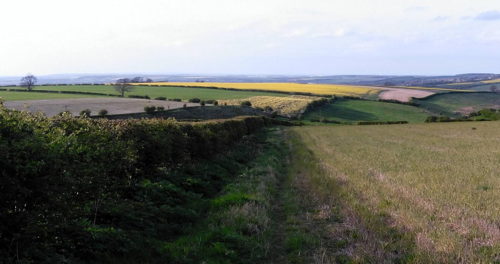
The Lincolnshire Wolds is the highest area on the East of England between Yorkshire and Kent and so there are many structures that take advantage of the elevation. In addition to Belmont we could see the Radar station at Wolds Top/Normanby Hill and Lincoln Cathedral in the distance, but we were interested in what was in front of us the remains of RAF Stenigot.
 | ||
| The tower at RAF Steingot, clearly visible as we climbed |
 | |
| View back |
After the Second World War, the site was retained and in 1959 it was upgraded to a communications relay site as part of the NATO ACE High system, which involved adding four tropospheric scatter dishes. The site was decommissioned in the late 1980s and was mostly demolished by 1996 but the toppled dishes remain.
 |
| View of RAF Stenigot |
 | |
| The dishes as seen from the footpath |
 |
| At the gate (locked) to the site |
 |
| View looking towards the radar tower |
 |
| Yours truly |
 |
| ET Phone Home! |
 |
| CQ CQ M0NRD/P |
 |
| The Chain Home Radar tower |
 | |
| The "Heavy Mob" Security Patrol |
What's more you aren't far from the Lincolnshire Coast, so after our walk we went to Mablethorpe for the afternoon and fish and chips which were well received.
 |
| Eddie enjoying his fish and chips |
Out portable on the Lincolnshire Wolds
This Easter weekend we decided to go out with the dogs and combine three hobbies, walking, geocaching and amateur radio whilst taking the opportunity to visit some radio related relics of World War II and the Cold War on the Lincolnshire Wolds.
Following a recent presentation at the South Kesteven ARS by David Gordon G6ENN where he talked about his successful portable operating I was encouraged to constructed a simple dual band 'flower pot' antenna (design from VK2ZOI) using some RG58 coax and 25mm conduit.
My previous attempts at portable operating have largely involved HF and slightly heavy equipment (my Yaesu FT-857D and Sealed Lead Acid batteries) but I decided this time to try VHF/UHF as we were going to one of the highest spots in the area. This allowed me to travel light just taking along a Baofeng UV-5R and the antenna sticking out of the rucksack.
Parking up in Donington on Bain we had a short 4 mile circular walk planned allowing the wife to collect a dozen geocaches along the way with a short detour at the top to visit RAF Stenigot. The walk climbs to the top of a hill, but it isn't a long ascent by any means or overly strenuous. The view back included the impressive Belmont Transmission Tower (just visible over my shoulder in the picture above) which before it was shortened in 2010 was reputably the tallest structure of its type in the world.
The Lincolnshire Wolds is the highest area on the East of England between Yorkshire and Kent and so there are many structures that take advantage of the elevation. In addition to Belmont we could see the Radar station at Wolds Top/Normanby Hill and Lincoln Cathedral in the distance, but we were interested in what was in front of us the remains of RAF Stenigot.
RAF Stenigot was part of the Chain Home radar network during World War II, this early system used large antenna arrays suspended from large towers, one of which is now preserved as a Grade II listed structure which is still used by RAF Aerial Erector School for selection tests for possible recruits.
After the Second World War, the site was retained and in 1959 it was upgraded to a communications relay site as part of the NATO ACE High system, which involved adding four tropospheric scatter dishes. The site was decommissioned in the late 1980s and was mostly demolished by 1996 but the toppled dishes remain.
While on private land with no public right of way it is a simple matter to follow the field edge to get quite close, the actual site has been secured to prevent vandalism and is now home to a herd of bulls to deter trespassers!
We stopped in the shadow of the dishes for a drink and some refreshment and I got out the radio and attempted to make some contacts, but sadly it seemed like everyone was in still in bed. I could open quite a few nearby repeaters and put out calls but again nothing heard, hopefully ET had better luck!
Checking the equipment when I got home it seems the Baofeng radio has developed quiet TX audio, so it is likely people couldn't hear me. I haven't used these cheap radios much and know they are prone to issues but thought mine was okay. Oh well, at least I looked the part and got a few odd glances from the few walkers and locals we saw. What I didn't realise at the time is the hill is also the site of GB3LC but I did spot some amateur radio antennas nearby.
It really was a great morning walk in a part of the country which is on our doorstep but haven't really visited before. Getting up close to the dishes and the Radar mast was fascinating.
What's more you aren't far from the Lincolnshire Coast, so after our walk we went to Mablethorpe for the afternoon and fish and chips which were well received.
Might look at activating Wolds Top in the near future as it is also a SOTA summit!
Following a recent presentation at the South Kesteven ARS by David Gordon G6ENN where he talked about his successful portable operating I was encouraged to constructed a simple dual band 'flower pot' antenna (design from VK2ZOI) using some RG58 coax and 25mm conduit.
| |
| Completed 2m/70cm Flower Pot |
My previous attempts at portable operating have largely involved HF and slightly heavy equipment (my Yaesu FT-857D and Sealed Lead Acid batteries) but I decided this time to try VHF/UHF as we were going to one of the highest spots in the area. This allowed me to travel light just taking along a Baofeng UV-5R and the antenna sticking out of the rucksack.
|
| Just setting off with Boris & Eddie |
Parking up in Donington on Bain we had a short 4 mile circular walk planned allowing the wife to collect a dozen geocaches along the way with a short detour at the top to visit RAF Stenigot. The walk climbs to the top of a hill, but it isn't a long ascent by any means or overly strenuous. The view back included the impressive Belmont Transmission Tower (just visible over my shoulder in the picture above) which before it was shortened in 2010 was reputably the tallest structure of its type in the world.
| |
| Belmont Transmission Tower |
The Lincolnshire Wolds is the highest area on the East of England between Yorkshire and Kent and so there are many structures that take advantage of the elevation. In addition to Belmont we could see the Radar station at Wolds Top/Normanby Hill and Lincoln Cathedral in the distance, but we were interested in what was in front of us the remains of RAF Stenigot.
| ||
| The tower at RAF Steingot, clearly visible as we climbed |
| |
| View back |
After the Second World War, the site was retained and in 1959 it was upgraded to a communications relay site as part of the NATO ACE High system, which involved adding four tropospheric scatter dishes. The site was decommissioned in the late 1980s and was mostly demolished by 1996 but the toppled dishes remain.
|
| View of RAF Stenigot |
| |
| The dishes as seen from the footpath |
|
| At the gate (locked) to the site |
|
| View looking towards the radar tower |
|
| Yours truly |
|
| ET Phone Home! |
|
| CQ CQ M0NRD/P |
|
| The Chain Home Radar tower |
| |
| The "Heavy Mob" Security Patrol |
What's more you aren't far from the Lincolnshire Coast, so after our walk we went to Mablethorpe for the afternoon and fish and chips which were well received.
|
| Eddie enjoying his fish and chips |
LoRa LoRa Laughs!
Due to the restrictions on airborne amateur radio operation in the UK High Altitude Balloon (HAB) enthusiasts have been forced to utilise licence exempt low power devices in novel ways to make radio trackers for their payloads. I have written plenty on this blog about my HAB tracking, the UKHAS distributed listener network and my own flights.
Until recently the preferred method was to use RTTY transmissions, however the advent of the IoT (Internet Of Things) has seen manufacturers of radio modules develop devices to increase both the range and reliability of communication between 'connected' embedded devices.
One such development are LoRa devices, primarily for devices to connect to a global wide-area network LoRaWAN, more information can be found at the LoRa Alliance in addition there are some open hobbyist networks such as The Things Network using these devices.
Using chirp spread-spectrum modulation these LoRa devices are marketed as being capable of robust, interference and fade resistant communication over longer distances and higher data rates.
The UK HAB community has begun experimenting with these devices and one of their keen proponents is Dave Akerman (M0RPI). Dave has developed both payload software for the "Pi In The Sky" PITS tracker along with Anthony Stirk (M0UPU) and gateway software in collaboration with Robert Harrison M0RJX. The 'gateway' is the necessary receiver element to upload the data to the tracking system. (all software is on the PITS Github page)
Dave gave an informative presentation on LoRa at the UKHAS 2016 Conference which is now available online (starts around 3 minutes in)
I had intended to fly a LoRa transmitter on my 2015 Hamfest balloon but it stopped working at the eleventh hour and hadn't done anything else with LoRa till recently.
Spurred on by the conference presentation and the fact more and more flights are carrying LoRa I invested in one of the Raspberry Pi expansion boards sold by Uputronics and built up another prototype tracker with a working LoRa module.
I have done talks at various radio clubs and societies and demonstrated it working but hadn't actually received a 'real flight' as opportunities have been scarce due to the weather. However in the few weeks I have tracked a couple of flights receiving both telemetry and image data, getting a couple of complete images from the imaginatively named 'SPACE' flight.
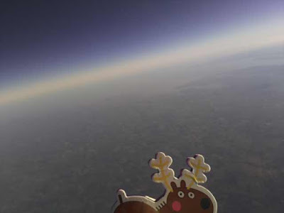
Dave Akerman also flew a flight experimenting with multiple payloads using Time-division multiplexing (TDM). It had 10 small of "AVRLoRaNut" trackers (of Anthony M0UPU's design) all set to the same frequency (434.450MHz) and same transmission mode. The trackers took turns to transmit, with each one allocated a particular transmission slot in a 20-second cycle. The cycle was GPS-timed but, if any tracker lost GPS lock then it derived timing from the transmissions from the other trackers (the LoRa devices are also receivers) All 10 trackers were suspended from the same balloon. This was in preparation for the 'Operation Outward' re-enactment next year (Steve Randall gave a presentation on it in the above conference video starts 1 hour 16 mins in)
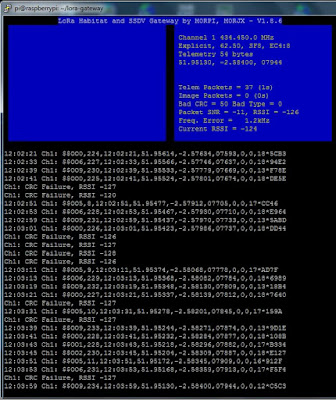
I successfully received telemetry despite the flight not being local and constantly heading away from me as can be seen in the screen shots.
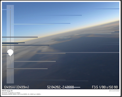
Always a busy man Dave also flew a flight with an experimental camera setup. The SSDV images this time came from a Nikon compact camera, connected to the Raspberry Pi via USB, and using gphoto2 software to take and transfer images to the Pi where they were stored, resized and converted to SSDV format for transmission. These were large images with a high quality SSDV setting so lots of packets per image, approx 1400 per image in testing.
This flight was using a 868MHz LoRa device, rather than the usual 434MHz due to the IR2030 restriction on bandwidth and duty cycle. Dave was using his Turbo-X or Mode 4 setting which is as fast as LoRa will go within IR2030 bandwidth restrictions (approx 8 packets / 2k bytes per second)
I hastily ordered a 868MHz device and soldered it in the spare slot on my gateway and built a collinear for 868MHz similar to the one I built for ADB-S reception (see video here).

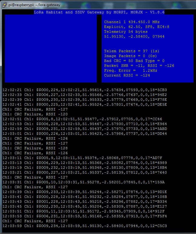
You can see it lashed up just below the dual-band collinear - not ideal mounting and it wasn't tested in anyway, built blind! The less than optimal setup at UHF, the insane data rate and the distance (>100miles) were going to make reception difficult, so I was pleased I did manage to receive telemetry and image packets.
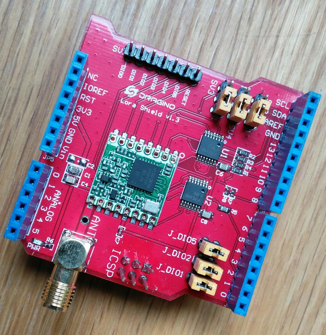
Most of the current LoRa development in the HAB community has tended to be on the Raspberry Pi due to the use with SSDV and the easy availability of cameras and ready built kit. LoRa is of course available on the Arduino platform and I had purchased a couple of 'Dragino' shields (pictured below) with a LoRa device on.

Dave has done some work on a AVR tracker software and a simple Arduino 'Serial' LoRa receiver. The receiver connects to a host PC appearing as a serial port and by running some gateway software the receiver can be configured via the serial link and received data is sent back to the gateway to be uploaded to the Habitat tracking system and SSDV system - the software can be seen here during the 'Operation Outward' test flight.

This gateway software is written in Pascal using Delphi and is not as functional as the Raspberry Pi Gateway software. Dave has made the source code available but I am not au fait at all with Delphi however I installed the free development IDE and intended to get in and make modifications but it seems to require a non-free(?) library for the serial comms so ditched the idea.
Instead I have spent the last few days developing a C# .NET version using Microsoft Visual Studio (the community version is free) and also have been modifying the Arduino code in the receiver to add functionality, such as storing the SSDV images locally.
It is still a work in progress but I have made a video showing the current state
Anyway as Cilla Black would say it's been a Lorra Lorra Laughs!

Until recently the preferred method was to use RTTY transmissions, however the advent of the IoT (Internet Of Things) has seen manufacturers of radio modules develop devices to increase both the range and reliability of communication between 'connected' embedded devices.
One such development are LoRa devices, primarily for devices to connect to a global wide-area network LoRaWAN, more information can be found at the LoRa Alliance in addition there are some open hobbyist networks such as The Things Network using these devices.
Using chirp spread-spectrum modulation these LoRa devices are marketed as being capable of robust, interference and fade resistant communication over longer distances and higher data rates.
The UK HAB community has begun experimenting with these devices and one of their keen proponents is Dave Akerman (M0RPI). Dave has developed both payload software for the "Pi In The Sky" PITS tracker along with Anthony Stirk (M0UPU) and gateway software in collaboration with Robert Harrison M0RJX. The 'gateway' is the necessary receiver element to upload the data to the tracking system. (all software is on the PITS Github page)
Dave gave an informative presentation on LoRa at the UKHAS 2016 Conference which is now available online (starts around 3 minutes in)
I had intended to fly a LoRa transmitter on my 2015 Hamfest balloon but it stopped working at the eleventh hour and hadn't done anything else with LoRa till recently.
Spurred on by the conference presentation and the fact more and more flights are carrying LoRa I invested in one of the Raspberry Pi expansion boards sold by Uputronics and built up another prototype tracker with a working LoRa module.
I have done talks at various radio clubs and societies and demonstrated it working but hadn't actually received a 'real flight' as opportunities have been scarce due to the weather. However in the few weeks I have tracked a couple of flights receiving both telemetry and image data, getting a couple of complete images from the imaginatively named 'SPACE' flight.

Dave Akerman also flew a flight experimenting with multiple payloads using Time-division multiplexing (TDM). It had 10 small of "AVRLoRaNut" trackers (of Anthony M0UPU's design) all set to the same frequency (434.450MHz) and same transmission mode. The trackers took turns to transmit, with each one allocated a particular transmission slot in a 20-second cycle. The cycle was GPS-timed but, if any tracker lost GPS lock then it derived timing from the transmissions from the other trackers (the LoRa devices are also receivers) All 10 trackers were suspended from the same balloon. This was in preparation for the 'Operation Outward' re-enactment next year (Steve Randall gave a presentation on it in the above conference video starts 1 hour 16 mins in)
I successfully received telemetry despite the flight not being local and constantly heading away from me as can be seen in the screen shots.
Always a busy man Dave also flew a flight with an experimental camera setup. The SSDV images this time came from a Nikon compact camera, connected to the Raspberry Pi via USB, and using gphoto2 software to take and transfer images to the Pi where they were stored, resized and converted to SSDV format for transmission. These were large images with a high quality SSDV setting so lots of packets per image, approx 1400 per image in testing.
This flight was using a 868MHz LoRa device, rather than the usual 434MHz due to the IR2030 restriction on bandwidth and duty cycle. Dave was using his Turbo-X or Mode 4 setting which is as fast as LoRa will go within IR2030 bandwidth restrictions (approx 8 packets / 2k bytes per second)
I hastily ordered a 868MHz device and soldered it in the spare slot on my gateway and built a collinear for 868MHz similar to the one I built for ADB-S reception (see video here).

You can see it lashed up just below the dual-band collinear - not ideal mounting and it wasn't tested in anyway, built blind! The less than optimal setup at UHF, the insane data rate and the distance (>100miles) were going to make reception difficult, so I was pleased I did manage to receive telemetry and image packets.

Most of the current LoRa development in the HAB community has tended to be on the Raspberry Pi due to the use with SSDV and the easy availability of cameras and ready built kit. LoRa is of course available on the Arduino platform and I had purchased a couple of 'Dragino' shields (pictured below) with a LoRa device on.
Dave has done some work on a AVR tracker software and a simple Arduino 'Serial' LoRa receiver. The receiver connects to a host PC appearing as a serial port and by running some gateway software the receiver can be configured via the serial link and received data is sent back to the gateway to be uploaded to the Habitat tracking system and SSDV system - the software can be seen here during the 'Operation Outward' test flight.

This gateway software is written in Pascal using Delphi and is not as functional as the Raspberry Pi Gateway software. Dave has made the source code available but I am not au fait at all with Delphi however I installed the free development IDE and intended to get in and make modifications but it seems to require a non-free(?) library for the serial comms so ditched the idea.
Instead I have spent the last few days developing a C# .NET version using Microsoft Visual Studio (the community version is free) and also have been modifying the Arduino code in the receiver to add functionality, such as storing the SSDV images locally.
It is still a work in progress but I have made a video showing the current state
Anyway as Cilla Black would say it's been a Lorra Lorra Laughs!

LoRa LoRa Laughs!
Due to the restrictions on airborne amateur radio operation in the UK High Altitude Balloon (HAB) enthusiasts have been forced to utilise licence exempt low power devices in novel ways to make radio trackers for their payloads. I have written plenty on this blog about my HAB tracking, the UKHAS distributed listener network and my own flights.
Until recently the preferred method was to use RTTY transmissions, however the advent of the IoT (Internet Of Things) has seen manufacturers of radio modules develop devices to increase both the range and reliability of communication between 'connected' embedded devices.
One such development are LoRa devices, primarily for devices to connect to a global wide-area network LoRaWAN, more information can be found at the LoRa Alliance in addition there are some open hobbyist networks such as The Things Network using these devices.
Using chirp spread-spectrum modulation these LoRa devices are marketed as being capable of robust, interference and fade resistant communication over longer distances and higher data rates.
The UK HAB community has begun experimenting with these devices and one of their keen proponents is Dave Akerman (M0RPI). Dave has developed both payload software for the "Pi In The Sky" PITS tracker along with Anthony Stirk (M0UPU) and gateway software in collaboration with Robert Harrison M0RJX. The 'gateway' is the necessary receiver element to upload the data to the tracking system. (all software is on the PITS Github page)
Dave gave an informative presentation on LoRa at the UKHAS 2016 Conference which is now available online (starts around 3 minutes in)
I had intended to fly a LoRa transmitter on my 2015 Hamfest balloon but it stopped working at the eleventh hour and hadn't done anything else with LoRa till recently.
Spurred on by the conference presentation and the fact more and more flights are carrying LoRa I invested in one of the Raspberry Pi expansion boards sold by Uputronics and built up another prototype tracker with a working LoRa module.
I have done talks at various radio clubs and societies and demonstrated it working but hadn't actually received a 'real flight' as opportunities have been scarce due to the weather. However in the few weeks I have tracked a couple of flights receiving both telemetry and image data, getting a couple of complete images from the imaginatively named 'SPACE' flight.
Dave Akerman also flew a flight experimenting with multiple payloads using Time-division multiplexing (TDM). It had 10 small of "AVRLoRaNut" trackers (of Anthony M0UPU's design) all set to the same frequency (434.450MHz) and same transmission mode. The trackers took turns to transmit, with each one allocated a particular transmission slot in a 20-second cycle. The cycle was GPS-timed but, if any tracker lost GPS lock then it derived timing from the transmissions from the other trackers (the LoRa devices are also receivers) All 10 trackers were suspended from the same balloon. This was in preparation for the 'Operation Outward' re-enactment next year (Steve Randall gave a presentation on it in the above conference video starts 1 hour 16 mins in)
I successfully received telemetry despite the flight not being local and constantly heading away from me as can be seen in the screen shots.
Always a busy man Dave also flew a flight with an experimental camera setup. The SSDV images this time came from a Nikon compact camera, connected to the Raspberry Pi via USB, and using gphoto2 software to take and transfer images to the Pi where they were stored, resized and converted to SSDV format for transmission. These were large images with a high quality SSDV setting so lots of packets per image, approx 1400 per image in testing.
This flight was using a 868MHz LoRa device, rather than the usual 434MHz due to the IR2030 restriction on bandwidth and duty cycle. Dave was using his Turbo-X or Mode 4 setting which is as fast as LoRa will go within IR2030 bandwidth restrictions (approx 8 packets / 2k bytes per second)
I hastily ordered a 868MHz device and soldered it in the spare slot on my gateway and built a collinear for 868MHz similar to the one I built for ADB-S reception (see video here).
You can see it lashed up just below the dual-band collinear - not ideal mounting and it wasn't tested in anyway, built blind! The less than optimal setup at UHF, the insane data rate and the distance (>100miles) were going to make reception difficult, so I was pleased I did manage to receive telemetry and image packets.
Most of the current LoRa development in the HAB community has tended to be on the Raspberry Pi due to the use with SSDV and the easy availability of cameras and ready built kit. LoRa is of course available on the Arduino platform and I had purchased a couple of 'Dragino' shields (pictured below) with a LoRa device on.
Dave has done some work on a AVR tracker software and a simple Arduino 'Serial' LoRa receiver. The receiver connects to a host PC appearing as a serial port and by running some gateway software the receiver can be configured via the serial link and received data is sent back to the gateway to be uploaded to the Habitat tracking system and SSDV system - the software can be seen here during the 'Operation Outward' test flight.
This gateway software is written in Pascal using Delphi and is not as functional as the Raspberry Pi Gateway software. Dave has made the source code available but I am not au fait at all with Delphi however I installed the free development IDE and intended to get in and make modifications but it seems to require a non-free(?) library for the serial comms so ditched the idea.
Instead I have spent the last few days developing a C# .NET version using Microsoft Visual Studio (the community version is free) and also have been modifying the Arduino code in the receiver to add functionality, such as storing the SSDV images locally.
It is still a work in progress but I have made a video showing the current state
Anyway as Cilla Black would say it's been a Lorra Lorra Laughs!


