Posts Tagged ‘SOTA’
 Double SOTA: Mosquito Peak and London Mountain
Mosquito Pass is a popular 4WD road in Colorado that takes you to 13,185 feet in elevation. It also provides access to two excellent SOTA summits, both over 13k feet: Mosquito Peak (W0C/SR-068) and London Mountain (W0C/SP-025). Joyce/K0JJW and I activated both summits on the same day. Fortunately, the weather cooperated nicely.

The Road
We drove the road to the pass from the east (via Highway 9, heading north out of Fairplay then turning west onto County Rd 12 / Mosquito Pass Road). Consult the Pike National Forest map for more detail.
We’ve driven over this pass many times over the years and the condition of the road has varied quite a bit. Right now, I’d call this a moderate 4WD road. You will find trail descriptions online that call Mosquito Pass “easy 4WD” but I think that information is out of date. Our stock Jeep Wrangler had no problem with it but I would not recommend driving the road with a Subaru-class crossover SUV.

Be aware that this road is closed by snow early in the fall and opens late in the summer. It is very unlikely to be passable in June and typically opens sometime in July. We decided to wait until August. Did I mention the road exceeds 13,000 feet in elevation? Check BushDucks for usually reliable pass information.
Mosquito Peak (W0C/SR-068)

At Mosquito Pass, we took an unmarked 4WD north towards Mosquito Peak. This road is not shown on the Pike National Forest map. The road was in good condition but is a narrow shelf road with limited opportunities to turn around. We parked the Jeep at an obvious turn-around spot and hiked on up the south ridge to the summit. No consistent trail, but a few cairns here and there. The one-way distance was about half a mile with 500 feet of vertical gain, so not very difficult.
It was quite windy on top so we hunkered down behind some rocks to provide some shelter. Using the Yaesu FT-90 transceiver and the 3-element Arrow 2m yagi, we worked these stations without much trouble: W0BV, N0EMU, KN0MAP, W0DLE, KD0VHD and W9GYA. Our best DX was N0EMU near Calhan, CO at about 100 miles.
London Mountain (W0C/SP-025)

To hike London Mountain, we drove back down the pass to the west end of the mountain and parked the Jeep at the point another 4WD road heads off to the south (see map). This road was gated closed and marked “no trespassing”.
We followed an obvious but unmarked trail leading from this small parking spot up the ridge of London Mountain. For the most part, we were able to follow this trail all the way to the summit. In a few spots it faded out but we stayed near the top of the ridge and always found it again. There were times when we really wondered if the trail’s route was the best option but it worked out fine. There are a few steep sections and places where we used our hands on rocks. The variety of rocks on this mountain (including marble) made it an interesting and fun hike. Following the top of the ridge also provided some ups and downs and many small false summits. The one-way distance is 0.85 miles with 600 vertical feet.
On top, we worked W0BV, W0DLE, N0EMU, KC0PBR, KN0MAP and KL7GLK on 2m FM. The wind dissipated a bit so it was more pleasant to hang out on this summit. We left the summit around 1 pm local with blue skies and a few puffy clouds all around.

These two summits are a great double-summit opportunity, as long as you have a capable 4WD vehicle. I suppose you could hike up the road but you probably can’t do both of the summits in one day.
73, Bob K0NR
The post Double SOTA: Mosquito Peak and London Mountain appeared first on The KØNR Radio Site.
Operating Tips for VHF SOTA
 Here are some operating tips that I have found useful when doing Summits On The Air (SOTA) on VHF. I’ve been using VHF and higher frequencies for SOTA exclusively and have activated over 100 summits in Colorado (and other states such as California, Wyoming, New Mexico, North Carolina and Tennessee.)
The challenge with VHF and higher is that the radio range is limited compared with HF. (It really does help to bounce those signals off the ionosphere.) VHF propagation will vary depending on a lot of factors but for SOTA activations our range is typically 50 to 100 miles. In the backcountry of Colorado, a 50 mile radius may not include very many active radio amateurs, so you may come up short in terms of radio contacts.
First, take a look my blog posting about the basics: How To Do a VHF SOTA Activation
Next, here are some additional tips to having a successful activation:
Send Invitations
Get the word out to people that may be within range. I try to keep track of who I’ve worked in the past or know to be in a particular area and let them know when I’ll be activating. In some cases, I’ll go ahead and make a specific sked with a station. That is, we’ll meet on a particular frequency at a particular time, perhaps on CW or SSB for maximum weak signal performance.
Create an Alert and then Spot yourself on the sotawatch.org web page (using smartphone app).
Make Your Call
By the rules, SOTA contacts are always simplex, so on 2 meters the place to try is usually 146.52 MHz, the National Simplex Calling Frequency. (Some areas have established other 2m simplex frequencies to use for SOTA, so inquire locally.) This is the place to try calling.
Who are you going to find there? Hard to say. SOTA chasers will often listen to “five two”…that’s where they find SOTA activators. Also, there are radio hams that just like to hang out on 52…they like 2m fm operating but they don’t like repeaters so they listen here. You will also find that many mobile stations monitor 146.52 as they drive through rural areas. Basically, they are listening for anyone around but aren’t flipping from repeater to repeater as they change location. I’ll often hear 4WD enthusiasts, hikers, boaters, campers, etc. using Five Two.
Make It Sound Good
Realize that not everyone knows about SOTA so they may not know what the heck you are doing. Make a call such as this: “CQ CQ this is Kilo Zero November Romeo operating from Pikes Peak – Summits On The Air – anyone around?” Or “CQ 2 meters this is K0NR on Pikes Peak – Summits On The Air.”
Do a little bit of “selling” when you make your call. Sound like you are having fun.
Be Patient
Be patient. Sometimes it just takes time to accumulate your 4 QSOs to qualify for activator points. The few times I have been skunked on QSOs were when I did not have enough time, usually because storms were moving in. Keep calling every few minutes, taking a break once in a while to enjoy the view.
Try Other Frequencies
You may want to try other simplex frequencies, so know the band plan for the area you are activating in. Another trick is to get on a local 2m repeater and ask for someone to move over to simplex to work you. I have not had to do this very often but it does work. Have some of the local repeaters programmed into your radio.
Improve Your Station
Hopefully by now you know that using an HT with a rubber duck antenna is a bad idea. Get at least a half-wave vertical or roll-up j-pole antenna. Better yet, get a small yagi antenna to add 5 or 6 dB to your signal. It can make a big difference on who you can work. I’ve even started carrying a small 2m/70cm transceiver to get my 2m transmit power up to 30W.
Another angle is to use SSB and CW, which are much better for weak signal performance (compared to FM). This sets you up to work the serious VHF stations which tend to use these modes and have large high-gain antennas (horizontally polarized).
73, Bob K0NR
The post Operating Tips for VHF SOTA appeared first on The KØNR Radio Site.
Dakota SOTA Adventure
Most of our Summits On The Air (SOTA) activity is here in Colorado but every once in a while, Joyce/K0JJW and I get the opportunity to branch out to other locations. It’s a fun thing to do with SOTA…do a little hiking, sightseeing and ham radio operating. On this trip, we decided to visit the Black Hills region of South Dakota, a place we had enjoyed many years ago.

Our general approach was to identify a list of SOTA summits that were not too difficult, with reasonable activator points (>6) and in locations we wanted to visit. (One good method is to use the SOTA database to sort summits by points, then look for ones that have been activated the most. Those are usually easy to access.) I noticed that Gary/KT0A had activated all of the summits on my list so I emailed him and received some great advice. Gary has also provided most of the activation notes in the SOTA database, which proved to be helpful. Thanks, Gary.
We use VHF and UHF exclusively for our SOTA activations, so I was a bit concerned about whether we’d find enough VHF activity in the area. Typically, we can work 100 miles or so on 2m FM from a summit without too much trouble but if no one is out there, it’s kind of difficult to make radio contact. South Dakota is not the most populous state, so it was a concern.
We spent three days in the western South Dakota area: did three summits the first day, three summits the second day and two summits the third day. The Black Hills are about a 6 hour drive from the Denver area, which makes for a good SOTA destination from Colorado.
Scotts Bluff (W0N/PH-005)
Hey, wait a minute, this one is in Nebraska, not the Dakotas. It turns out Nebraska (W0N) has 15 SOTA summits, most of them in the pan handle of the state. Scotts Bluff (4649 feet) is located in Scotts Bluff National Monument and has historical significance as an important landmark on the Oregon Trail. This is an excellent example of the SOTA program providing that extra incentive to visit a new location that we otherwise would have skipped.

We drove to the parking lot near the summit followed by a short hike to the actual high point. (Yes, you can hike up from below if you’d prefer.) We ran into Bob/KC0OZ who is a volunteer at the national monument (and his dog Leeloo). I wasn’t sure how much VHF activity I would encounter on a weekday but we found quite a few friendly folks lurking on 2m FM in the area. I think Bob knew everyone that we worked on the 2m band.
Rankin Ridge (W0D/BB-089)
Inside Wind Cave National Park, Rankin Ridge is a 1-mile (200 feet vertical) loop trail in good condition, providing an easy hike to a lookout tower. (The lookout tower was marked “no entry”.) This was a very enjoyable hike and should be on the “must do” list for this area.

Mount Coolidge (W0D/BB-012)
Mount Coolidge is a drive-up summit (good gravel road, 2WD), easily accessible from Highway 87 in Custer State Park. It is the site of an historical rock lookout tower which is now encroached on by many radio towers. The Custer State Park web site says the road to Mount Coolidge is generally open 9 am – 5 pm from Memorial Day into late September.

This summit is easy to access and provides some very good views of the Black Hills. Even though I’m a fan of radio towers and antennas, the way they surround the historic lookout tower really detracts from the summit. Don’t come here expecting a wilderness experience.
Odakota Mountain (W0D/BB-002)
This summit is a relatively easy bushwhack hike through grass and over some downed timber, less than a 1/2-mile in distance and only 100 feet vertical. You’ll want to have the Black Hills National Forest map guiding yourself to this summit. Actually, that map is useful for all of these summits in South Dakota.

Bear Mountain (W0D/BB-029)
Next up was Bear Mountain, another summit that has a lookout tower now accompanied by radio towers. (Not as bad as Mount Coolidge.) There is a good gravel road to the summit suitable for 2WD vehicles. Again, the Black Hills National Forest map is a great resource for access information.

Atlantic Hill (W0D/BB-037)
This summit was a reasonable bushwhack hike with lots of tall grass and significant downed timber. My GPS app measured the distance at 0.45 miles with 450 feet vertical.

We followed KT0A’s instructions from the SOTA website which took us to the west side of Atlantic Hill. Again, use the Black Hills National Forest map for guidance. The map below shows the road as “297 1G” but it was just labeled “G”. Also, note that the road is gated closed for part of the year. The “G” road looked a bit sketchy but turned out to be easy to navigate with our crossover SUV. The map below shows the track we took. There was no trail and at times the grass was very tall. All things considered this was a good hike and the summit is quite pleasant.

Cicero Peak (W0D/BB-009)
Cicero Peak has a rocky road (FS 338) to the summit, OK for high clearance 2WD vehicles. There’s a small radio site at the summit. The views are probably wonderful but we did not see any because of the low hanging clouds when we were there. This road also has a gate at the bottom and is closed seasonally.

Custer Mountain (W0D/BB-010)
Custer Mountain was the toughest hike of the trip…a bushwhack through tall grass, downed timber and plenty of rock near the summit. Actually, the worst part was the swarms of gnats that followed us everywhere — they were out in full force after the rainy weather. Actually, I think it was the gnats that wore us out…difficult to step over rocks and logs when you’re swatting the little buggers.

Again, we followed KT0A’s activation notes on the SOTA web site. There is really no “good” way to ascend the mountain but the map below shows the track we used to descend the mountain. It has a few less rocks and downed trees to climb over. The key is to approach the summit from the west/northwest. The distance recorded on my GPS app was 0.83 miles and 650 feet vertical.

Radio Operating
Our radio gear varied from summit to summit but we always carried a Yaesu FT-90 2m/70cm transceiver, an Arrow 3-element yagi for 2m, dualband j-pole for 2m/70cm and a gaggle of handheld transceivers. On most of the summits, we also had the FT-817 so we could work CW/SSB on 2m and 6m. As usual, most of the contact were on 146.52 MHz FM, using the FT-90.
NC0K and W0FUI were listening a lot and worked us on 5 summits, KE0LXT snagged us on 4 summits (and met us in person on Bear Mountain). We worked KD0UST from 2 summits.
Our longest distance QSOs were with Jim/WD0BQM in Mitchell, NE (grid DN81cw). From Scotts Bluff we both worked Jim on 2m FM at relatively short range. On Odakota Mountain, we worked Jim/WD0BQM in Mitchell, Nebraska (Grid DN81cw) on 2m at a distance of 139 miles. I initially worked Jim on CW with very good signals. Joyce also worked him on SSB but she had to work a bit to complete that contact. From Bear Mountain, I worked Jim on 2m CW again with some difficulty because signals were clearly weaker but Joyce was not able to complete using SSB. Thanks for getting on the air with us, Jim!
I made one 6m ssb contact with K0CX from Bear Mountain. Other stations worked during the trip: KC0WVE, N8XBD, WB0VAO, KB0ZXH, KL7MH, N0SQ, W0SSB, KD0QDG, KD0ZIP, AF0DJ, KD0ZIR, W0NIL, W7REA, K0CX, WB0PZQ, N0DUX, N0DUW, KC0GWU, W3MEB, W7LFB, W0LFB, KF0XO. We managed to make at least 4 QSOs on each summit without too much difficulty by calling on 146.52 MHz. On Custer Mountain, we got impatient and went over to the 146.85 MHz (Bear Mountain) repeater to beg for a simplex contact. Thanks, KF0XO.
It was a great trip to a beautiful part of the western United States. We met some really nice hams along the way. Thanks to everyone that took the time to work us on the summits.
73, Bob K0NR
The post Dakota SOTA Adventure appeared first on The KØNR Radio Site.
Signal Butte (W0C/FR-165): SOTA Activation

Signal Butte (W0C/FR-165) is a popular Summits On The Air (SOTA) summit about 8 miles north of Florrisant, Colorado. Joyce/K0JJW and I had this one on our SOTA list for a while now and finally got around to activating it. At an elevation of only 9459 feet, it is not a big mountain but it provides a spectacular 360 degree view of the surrounding area. Signal Butte is within the Hayman Wildfire burn area from June 2002 and you can still clearly see the effects of that fire.

To get to the trailhead, consult the USFS Pike National Forest Map. Drive to the trailhead using FS 362, then turning onto FS 362A which leads to a well-used parking area. These roads are easy-peasy 4WD and high-clearance 2WD is probably sufficient.

The well-constructed trail is only a half mile long and 540 feet vertical, with many tight switchbacks and rock steps. I’d call this a good visitor hike because it will get most people huffing and puffing so they feel like they really did some climbing but then reward them with outstanding views on top.

On the Air
We both operated mostly on 2m FM (146.52 MHz) with the Yaesu FT-90 cranking out 30W into an 3-element yagi antenna. The best DX for the day was Dave/N0KM about 107 miles away in the San Luis valley (DM67vr). Note that our signals had to find their way across several mountain ranges for us to make contact. Who says VHF is only line of sight?
Steve/WG0AT showed up on Mount Herman (W0C/FR-063) for a summit-to-summit SOTA QSO. Then later, Doug/KD5OUG called us from the summit of Mount Evans (W0C/FR-003) for another summit-to-summit contact. Apparently Doug was just playing tourist and decided to pull out his 2m HT and give a call. Thanks to these stations that contacted us: K0LJW, W0RW, WG0AT, KC0PBR, K0MGL, KD0MRC, N0KM, N0EMU, KD0VHD, K0PV, K0PWO, W0BV, WB0TGE, K0GPA, K0TPC, WZ0N, KD0OUG

As you can see from the photos, the weather was excellent so we really enjoyed being on this summit. We both really enjoyed this summit and we will probably be back. This one is highly recommended because of the easy access, reasonable difficulty, established trail and excellent radio and optical horizons.
73, Bob K0NR
The post Signal Butte (W0C/FR-165): SOTA Activation appeared first on The KØNR Radio Site.
Colorado 14er Event (2018)
![]() August 4 & 5, 2018
August 4 & 5, 2018
Saturday and Sunday
www.ham14er.org
Amateur Radio operators from around Colorado will be climbing many of Colorado’s 14,000-foot mountains and Summits On The Air (SOTA) peaks to set up amateur radio stations in an effort to communicate with other radio amateurs across the state and around the world. Join in on the fun during the 27th annual event and see how many of the mountaintop stations you can contact. The covers the entire weekend but many mountaintop activators will hit the trail early with the goal of being off the summits by noon due to lightning safety concerns.
Now including Summits On the Air (SOTA), which adds over 1700 potential summits! If you aren’t up to climbing a 14er, there are many other summits to choose from (with a wide range of difficulty). See the Colorado SOTA web page at w0c-sota.org
Radio operators who plan to activate a summit should post their intent on the ham14er Yahoo Group. To subscribe to the “ham14er” email list, visit the Yahoo groups site at http://groups.yahoo.com/group/ham14er/ . Also, be sure to check out the event information at http://www.ham14er.org It is also a great idea to post an ALERT on the SOTAwatch.org website.
Frequencies used during the event
Activity can occur on any amateur band including HF and VHF. The 2m fm band plan uses a “primary frequency and move up” approach. The 2m fm primary frequency is 147.42 MHz. At the beginning of the event, operators should try calling on 147.42 MHz. As activity increases on that frequency, move on up the band using the 30 kHz steps. Don’t just hang out on 147.42 MHz…move up! The next standard simplex frequency up from 147.42 MHz is 147.45 MHz, followed by 147.48 and 147.51 MHz.
| Frequency (MHz) | Comments | Frequency (MHz) | Comments |
| 147.42 | Primary 2m FM Frequency, then up in 30 kHz steps | 7.032 | 40m CW Frequency |
| 147.45 | Alternate 2m FM frequency | 7.185 | 40m SSB Frequency |
| 147.48 | Alternate 2m FM frequency | 10.110 | 30m CW Frequency |
| 147.51 | Alternate 2m FM frequency | 14.060 | 20m CW Frequency |
| 446.000 | Primary 70 cm FM frequency | 14.345 | 20m SSB Frequency |
| 446.025 | Alternate 70 cm FM frequency | 18.092 | 17m CW Frequency |
| 1294.50 | Primary 23cm FM frequency | 18.158 | 17m SSB Frequency |
| 144.200 | 2m SSB calling frequency | 21.060 | 15m CW Frequency |
| 50.125 | 6m SSB calling frequency | 21.330 | 15m SSB Frequency |
| 28.060 | 10m CW Frequency | ||
| Other Bands/Modes | Standard calling frequencies and/or band plans apply. | 28.350 | 10m SSB Frequency |
Warning: Climbing mountains is inherently a dangerous activity.
Do not attempt this without proper training, equipment and preparation.
More operating information here: www.ham14er.org
Sponsored by The Colorado 14er Event Task Force
Download: Colorado 14er Event Flyer 2018
The post Colorado 14er Event (2018) appeared first on The KØNR Radio Site.
VHF SOTA: Abajo Peak (W7U/SU-014)
While on a canyon country hiking/Jeeping trip in Utah, Joyce/K0JJW and I decided to do a couple of Summits On The Air (SOTA) activations. Abajo Peak (W7U/SU-014) showed up as a suitable target, being an easy-access drive-up summit at 11,360 feet, just west of Monticello. While the forest service map shows this as a 4WD route, it turned out to be a well-maintained road that most 2WD vehicles can handle.

The map below shows the area. The only real challenge was finding B102 heading south/southwest out of Monticello. This later turns into route 0087, which swings south of another SOTA summit: South Peak (W7U/SJ-003) and up over Dickson Pass. (South Peak could be a second summit for a double activation.)

Abajo Peak is an excellent summit for VHF/UHF propagation with a good radio horizon in all directions. There is a substantial radio communications site on top which did create some local interference on 2m and 70cm. Moving a bit away from the actual summit caused the interference to mostly disappear.
I was concerned that we would not find enough activity on VHF in this rural location, so I put the word out to some of the hams in Utah and western Colorado with capable 2m SSB stations. Our equipment was a Yaesu FT-817 (all mode, 5W) driving a 3-element yagi antenna. We also had a 50W Yaesu FT-90 that can provide a bit more power out on 2m FM. And we had the usual collection of HTs.

Around noon, we started calling on 146.52 MHz and worked N7VWX in Nucla, CO (about 57 miles away). We switched over to 144.200 SSB and worked W0DSW in Cedaredge, CO (113 miles). Then we worked Bill/K0UK in Grand Junction (95 miles) on 144.200 SSB…not real strong but we made it. A bit later we came across KB7REB on 146.52 FM who said he was out hiking in a canyon and was surprised to hear anyone. We also worked KB7TRA on 146.52 (I think he was mobile east of us). We also worked W0DBB in Montrose, CO. I kept beaming to the west looking for W7DHH and I eventually heard him calling on 144.200 CW. I tried getting back to him but he was apparently not hearing me. N7KMK (same vicinity as W7DHH) came on the air and I was able to copy him on SSB. He also had trouble hearing me, but for a few seconds the signals came up a bit and we made the contact. N7KMK was my best DX for the day at 154 miles.
Four contacts are required to get the SOTA activation points and we probably would have been successful just randomly calling on 146.52 MHz FM. However, taking along the SSB transceiver and alerting the 2m weak-signal crowd certainly paid off with some longer distance QSOs. It is always a blast to be working over 100 miles on VHF QRP.
73, Bob K0NR
The post VHF SOTA: Abajo Peak (W7U/SU-014) appeared first on The KØNR Radio Site.
The Pedernal – My SOTA Activation
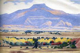 |
| Pedernal Painted by Georgia O'Keefe 1942 |
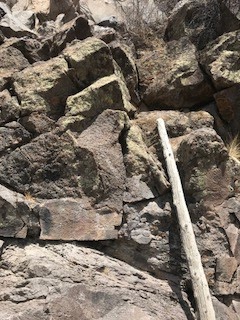 |
| The Near Vertical Climb The actual route is up the left side |
 |
| AD5A and KT5X on the summit of the Pedernal |
 |
| AD5A on top of the Pedernal |
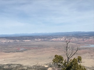 |
| View from the top |


