The SOTA Management Team launched a special challenge for 2026: a distance-based scoring challenge using CW and SSB on the 2m and 70cm bands. The announcement is here on the SOTA reflector.
The basic idea is to encourage SOTA contacts using CW or SSB on these two bands. Because the scoring is based on distance, you need to enter the location of the other station. When chasing a summit, the location is already known by the SOTA database, but you need to have your location entered into the logging system. Summit-to-Summit contacts are easy to log because both locations are known. The hassle comes up when you are activating a summit and need the chaser’s location. An easy way to share location info is using the 6-character grid locator (e.g., DM78av at my house). Some chasers may know their 6-character locator but you may need to look it up. I usually ask the other operator if they are operating at home so I can look up the grid later. If they are away from home, I ask for enough information to be able to determine their grid.
W0C Activity
I wasn’t sure how many folks would pursue this challenge here in Colorado, but we are off to a good start. Here’s the current activator summary:
K0JJW and I have activated 5 times for the challenge, and have been pleasantly surprised with the number of chasers who get on, primarily using 2m SSB. It seems that some hams have 2m SSB capability, but don’t have many opportunities to use it. So they come out to play!
There are a few things to be aware of when operating these bands and modes:
Antenna Polarization
The first thing we ran into was the need to make sure both stations have the same antenna polarization. Common practice on VHF/UHF is to use vertical polarization for FM (and similar modes), but use horizontal polarization for CW/SSB and other weak-signal modes. The serious stations on CW/SSB will tend to have large Yagi antennas, horizontally polarized. But we soon found that many of the chasers at home were using vertical antennas on CW/SSB, because that’s what they have set up. No problem, on the summit we just flipped our handheld Yagi antenna to be vertical. The point is that antenna polarization should be taken into account, else you can experience a substantial signal loss.
Tuning in SSB
Another issue that surfaced is the need to do more precise tuning when using SSB. For FM, you can just dial in 146.52 or whatever and call it good. If there is a small frequency difference between stations, it does not matter. On SSB, a few hundred Hertz of frequency difference (which is common) causes the familiar “Donald Duck” effect, so you need to tune more carefully.
Most people know that the 2m SSB calling frequency is 144.200 MHz, so they start there. But if you hear an activator on 144.2001, you should tune to match their frequency when you call them. Don’t just sit on 144.200 and think “the other station is off frequency.”
Calling Frequency
Some sources list 144.100 or even 144.060 as the 2m CW calling frequency. These frequencies can be used, but common practice in Colorado is to just call CW or SSB on 144.200 MHz. That way, people monitoring the band for activity can find it more easily. Same thing with 432.100 MHz on the 70 cm band. Clearly, posting spots on SOTAwatch can really help with making CW & SSB contacts.
When activity picks up, the calling frequency can get busy. This is why most radios have a big knob on the front of the radio that allows you to tune up or down. Standard practice is to move up 5 or 10 kHz, as needed. If you are operating on the calling frequency for a long period of time, you should not be surprised if other people show up on frequency. It works best if everyone cooperates, shares the frequency, and moves to adjacent frequencies when possible. This is similar to how 146.52 MHz can get busy on FM, so people shift to using 146.58 MHz to spread things out.
Quansheng UV-K5
Various people have hacked the Quansheng UV-K5, a dualband HT, to operate using CW and SSB. The modification consists of loading new firmware and, in some cases, doing a simple hardware modification. This video provides an overview of how this works. Many people are having fun modifying this HT, and it is an inexpensive way to get up and running on CW/SSB.
Happy New Year! This first issue of 2026 spans 110 pages and
offers a comprehensive exploration of amateur radio. Readers will find a
diverse mix of content, including technical projects, the latest operating
news, and engaging historical perspectives relevant to the amateur radio
community.
Historical and Informative Features
Readers will find historical profiles of
notable figures in radio, this time including Edouard Branly, inventor of the
coherer, and the fateful and communications-stricken flight of Amelia Earhart. The Silent Revolution: The future of RF is in light, is an overview of transceivers using light rather than wires, promising less noise and terrific bandwidth. You will find tutorials on a variety of relevant subjects including HF digital
modes such as FT8 and JS8Call, suggestions for contest logging software, and
tips for successful portable operations.
Technical Articles
Several articles in this issue delve into
practical projects and technical experimentation. Topics covered include encrypted
communications in amateur radio, antenna construction and tuning, including the
revolutionary Challenger+, low-power (QRP) operating strategies, free access to
online software-defined radio receivers, and modifications to homebrew
equipment. Additional articles address emergency communications preparedness,
recent regulatory changes affecting Canadian amateurs, and reviews of new ham
radio products and books.
Regular Sections
The issue includes our regular informative columnists,
providing valuable information for operators.
They include feature propagation forecasts, updates on satellite and
digital modes, reports on VHF/UHF activity, summaries of recent contests and
on-air events, and even a ‘snow muffin’ recipe for Winter Field Day.
Feature Article: Embracing Versatility in Amateur Radio
An opinion piece reflected by the cover:
“Are you an Amateur Radio chameleon?” (p. 102), employs the chameleon as a
metaphor for versatility in the hobby. Drawing on the Senegalese proverb, “The
chameleon changes colour to match the earth, the earth doesn’t change colour to
match the chameleon,” the article gently critiques operators who specialize
exclusively in one aspect of amateur radio—whether chasing DX on HF, focusing
on VHF repeaters, contesting year-round, or limiting activity to digital modes
like FT8.
While acknowledging that specialization can
foster deep expertise, the article contends that remaining in a single niche
may restrict personal growth and diminish the enjoyment of amateur radio.
Instead, it celebrates those who adapt fluidly, moving between CW, SSB, digital
modes, satellite work, QRP portable activations, microwave experimentation,
public service events, and homebrewing. These “chameleons,” the article
suggests, find greater fulfillment and contribute more broadly to the amateur
radio community.
It concludes with an invitation for readers
to share their own stories of adaptation and discovery by emailing [email protected].
I always have an operating goal in sight to motivate me to get on the air. On the HF bands, I followed the typical progression of getting Worked All States (WAS), Worked All Continents (WAC), and DX Century Club (DXCC). It seems that DXCC receives all the glory and attention, with many DXers pursuing the goals of working all countries, I mean entities.
Worked All Zones
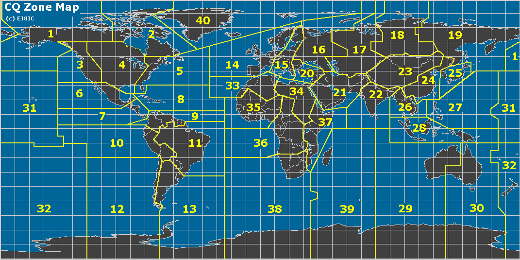
The Worked All Zones (WAZ) award is another well-known HF DX award, organized by geography. WAZ recognizes operators for establishing confirmed two-way radio contacts with stations in all 40 geographic zones defined by CQ’s official zone map. These zones divide the world into areas based on continents, regions, and specific entities (see the map below).
This zone-based structure emphasizes propagation challenges and global coverage, often making certain zones (e.g., remote Asian or polar areas) particularly difficult depending on the operator’s location. If the goal is to recognize “working the world,” this approach seems much more logical to me than the DXCC award. For DXCC, the initial award is for 100 countries/entities, which may or may not be spread worldwide. DXCC recognizes political boundaries, which result in many different entities clustered in small geographic areas. For example, the Caribbean is filled with many small countries that are easily accessible from the US. Europe is also dense with countries. The WAZ award requires you to work stations all over the world.
My Journey
I had not paid too much attention to working all zones until recently. I began tracking them and making a point to chase the ones I needed. Of course, working DX already produced contacts with many zones around the world. I have a mixture of SSB, CW, and digital (FT8) contacts, so I was focused on the Mixed award. My HF station is modest, running 100 watts to an end-fed wire antenna. Towards the end, I was missing two zones: Zone 22 – Southern Zone of Asia (India, Bangladesh, etc.) and Zone 34 – Northeastern Zone of Africa (Sudan, South Sudan, Egypt, etc.).
I used FT8 to work these last two zones, working VU3RGB (Zone 22) in August. Then I finally worked Z81D (Zone 34) on 30m yesterday. I was pleased to get him in the log, and I quickly submitted the contact to Logbook of The World. The confirmation came through the same day. Very nice! Similarly, I submitted the confirmed contacts via LoTW to the WAZ awards manager (Jose/N4BAA), and the certificate arrived via email almost immediately. (I paid $8 to LoTW to transfer the confirmations and $12 to WAZ to process the award.)
This leads to the question of “what’s next?” in terms of operating goals.
Closing out 2025, here are the top five blog posts at k0nr.com during the year. Some people may see this as a lazy way to create one more blog post this year without much effort, and they would be right. These posts are the top five most viewed this year, but may have been written earlier.
Top Five Blog Posts
Leading the list is this blog post…a perennial favorite that seems to make the top five each year. This particular article is tuned for Colorado, but also provides a link to an article covering the topic for the USA.
In the third spot, we have another older article about 2m SSB that just keeps on getting views. I recently updated this article, which was written a long time ago.
Just for good measure, I am including one more notable post. This explains why I strongly favor using VHF and UHF frequencies for SOTA activations. It is all about Height Above Average Terrain.
A view of W0C/SP-096, also known as “Bow Tie Mountain”
On December 1, most SOTA summits in Colorado gain an additional 3 points due to the Seasonal (Winter) Bonus. Joyce/K0JJW and I were looking for a summit not too far away that was still accessible for us to activate. This time of year, many US Forest Service roads are gated shut. Other roads remain open but are not maintained, which means they become impassable as the snow accumulates.
Recently, Ray/KD8EQA reminded me of W0C/SP-096, an unnamed summit unofficially known as Bow Tie Mountain. Ray writes:
Once upon a time… many years ago… in a land of many mountains and many activators named Steve… two of the Steves, K7PX and WG0AT, became good friends and would often hike and activate together. … in the spirit of being silly and having fun… that one or both Steves could be seen wearing a tie during their activations. Soon, the unofficial challenge was underway to see who could show up with the coolest, “make a statement” tie. And this quickly led to the ultimate tie statement… a bow tie! So, guess which summit is credited with being the one where the most memorable, outlandish, bow tie antics took place… the one the Steves refer to as Bow Tie Mountain? Yup, it’s peak 10214, SOTA reference W0C/SP-096.
The complete Bow Tie Mountain story is here, along with an invitation to come play along. Other SOTA folks have activated SP-096 during the winter months, so it seemed likely to be accessible in early December. There was a couple of inches of new snow on the ground, but it was easy-peasy to drive the Jeep there.
Driving directions to SP-096, starting from Highway 9, south of Hartsel.
To get to SP-096, head south out of Hartsel on Highway 9. Then turn east/northeast on CR 116. You will drive right past Threemile Mountain (SP-107), a popular summit with year-round access. These two summits can be done together in the same day but opted just to do SP-096.
It is an easy hike to the summit, following the closed two-track road.
The parking spot for the trailhead is 38.86462, -10556085. There is an old 4WD road, now closed, that leads up to the saddle just west of the summit. It is an easy hike on the road, then off-trail to the summit. My GPS app clocked it as 0.5 miles one-way and 500 feet vertical. This is about as easy as it gets for a SOTA hike.
Joyce/K0JJW hiking on the abandoned road to the saddle.
Weather
The weather forecast for Dec 1 called for 27 degrees F at the summit, which turned out to be about right. I expected there would be enough wind to drive us off the summit quickly. “Hey, let’s get our four contacts and get the heck out of here.” Instead, the wind was mostly calm, the sun was out, and it was very pleasant.
With the incredible blue sky, the views were stunning in all directions. The fresh snow was just enough to add texture and definition to the various mountains and surrounding slopes.
Following established custom, we took this photo wearing bow ties on the summit. That is Pikes Peak in the background.
The 2m band was pretty quiet, but we did manage to work five stations on 2m FM. The best DX for the day was Matt/KF0RIG in Colorado Springs, about 45 miles away. This is not a very long distance for 2m FM, except that Pikes Peak is blocking the way. Matt had a Yagi at his house pointed at Pikes, and we did the same on our end. Somehow the signal got through, perhaps via knife-edge diffraction. I was impressed that we completed the contact.
Try It
This summit seems to be underappreciated, with only 29 activations. About one-third of these were done by one of the Steves (K7PX or WG0AT). This seems to happen with smaller, unnamed summits. But now it’s got a name and the Bow Tie tradition, so you are invited to give it a try.
Here’s an update on the most activated SOTA summits in Colorado. See my previous report here. Mount Herman (W0C/FR-063) still leads the pack by a wide margin, with many activations by Steve/WG0AT.
A view of Pikes Peak from Mt Herman.
Genesee Mountain has passed up Pikes Peak to take second place in the running. Genessee is in a park just outside of greater Denver and is easy to access. I notice many out-of-town SOTA enthusiasts going up there to get on the air and make some contacts. Pikes Peak is a 14er but has a road to the top, and most of those activations are probably aided by a vehicle. Chief Mountain is in fourth place. Mount Blue Sky (formerly Mount Evans) is also a 14er with a road to the top. However, it dropped off the list, due to the reduced access caused by recent road construction in the area.
Thorodin Mountain comes in at number five and seems to be gaining in popularity, with Carey/KX0R as a frequent activator.
The summit formerly known as Squaw Mountain, now Mestaa’ehehe Mountain (W0C/PR-082), comes in at sixth place. There is a gated road to the top, so most activators hike that road.
Most of these summits are in the Front Range section of W0C, close to the major cities, which aids their popularity. The other two are listed in the Sawatch and Park Ranges, but they are also not far from the large urban areas.
First in North America
In North America, Mount Herman is second only to Mount Davidson (W6/NC-423), which currently has 846 activations, many of them by Ellliot/K6EL. Davidson is a small 1-point summit in the middle of San Francisco, so it is easily accessible to a large population. This video by W6DFM provides a tour of that summit. Another notable summit is Vollmer Peak (W6/NC-298), an easy-to-access peak with 551 activations.
So that’s your update on SOTA activations in Colorado.
When I get asked why I only use VHF/UHF frequencies for my Summits On The Air (SOTA) activations, I usually reply with:
Height Above Average Terrain
More specifically, I mean that using VHF for SOTA is fun because Height Above Average Terrain (HAAT) has a dramatic effect on the propagation of my radio signal.
HAAT has a specific definition, found in the FCC regulations. HAAT basically describes the height of a transmitter relative to the surrounding terrain in all directions at distances of 3 to 16 km. This HAAT calculator tool provides the HAAT of a site based on its latitude and longitude. Note that the FCC definition of HAAT compares against the terrain relatively close to the transmitter, 16 km (10 miles). For SOTA purposes, we are more concerned with distances further away.
In a recent presentation on mountaintop VHF operating (Hamcon Colorado), I provided these two contrasting examples to drive home the importance of HAAT.
Punkin Center
Punkin Center is a small town located on the eastern plains of Colorado. The elevation is 5364 feet, and its HAAT is roughly zero feet. That is, the terrain is flat. Punkin Center is a fine place to be, but it is not a very good VHF location. The radio range using a 5-watt VHF handheld radio is about 4 miles.
Pikes Peak
Compare this to America’s Mountain, Pikes Peak, which has an elevation of 14,115 feet and a HAAT of 4,445 feet. That is, it rises more than 4,000 feet above the surrounding terrain. (The height advantage is even more pronounced when looking further east towards Kansas, where the highest elevation is ~4,000 feet.) Based on my experience operating from there, the VHF handheld range is over 100 miles.
The improved HAAT of Pikes Peak provides a VHF radio range that is 25 times better than Punkin Center. Again, nothing wrong with Punkin Center, but if I want to make VHF contacts, I’ll choose Pikes Peak.
Let’s compare this to using the High Frequency (HF) bands. The normal propagation mode on HF is skywave propagation via the F layer, which supports radio propagation across North America and around the world (depending on frequency, time of day, solar conditions, blah blah blah). The radio signal refracts off the ionosphere and can go very long distances. From Pikes Peak, I can work the world. From Punkin Center, I can work the world. Not much difference, except the views from Pikes are generally better, and the oxygen is less plentiful.
So when I hike up a mountain, I am excited to get out the VHF gear and see what contacts I can make due to the improved HAAT. I don’t get as excited about working HF, because I can do that from home…or Punkin Center, or other places, with similar results.
Other SOTA activators see it differently, and that is just fine. (VHF contacts represent only ~20% of all SOTA contacts.) There are many ways to enjoy SOTA and ham radio. Just make sure you have fun messing around with radios.
Each individual posting is the property of its respective author and the opinions expressed may not represent those of AmateurRadio.com including its editor, staff, or sponsors. Content may not be reproduced without written permission.
 SOTA Challenge: CW/SSB on 2m & 70cm
 The SOTA Management Team launched a special challenge for 2026: a distance-based scoring challenge using CW and SSB on the 2m and 70cm bands. The announcement is here on the SOTA reflector.
 K0JJW and I have activated 5 times for the challenge, and have been pleasantly surprised with the number of chasers who get on, primarily using 2m SSB. It seems that some hams have 2m SSB capability, but don’t have many opportunities to use it. So they come out to play!
 Various people have hacked the Quansheng UV-K5, a dualband HT, to operate using CW and SSB. The modification consists of loading new firmware and, in some cases, doing a simple hardware modification. This video provides an overview of how this works. Many people are having fun modifying this HT, and it is an inexpensive way to get up and running on CW/SSB.
 The Worked All Zones (WAZ) award is another well-known HF DX award, organized by geography. WAZ recognizes operators for establishing confirmed two-way radio contacts with stations in all 40 geographic zones defined by CQ’s official zone map. These zones divide the world into areas based on continents, regions, and specific entities (see the map below).
  This zone-based structure emphasizes propagation challenges and global coverage, often making certain zones (e.g., remote Asian or polar areas) particularly difficult depending on the operator’s location. If the goal is to recognize “working the world,” this approach seems much more logical to me than the DXCC award. For DXCC, the initial award is for 100 countries/entities, which may or may not be spread worldwide. DXCC recognizes political boundaries, which result in many different entities clustered in small geographic areas. For example, the Caribbean is filled with many small countries that are easily accessible from the US. Europe is also dense with countries. The WAZ award requires you to work stations all over the world.
 Closing out 2025, here are the top five blog posts at k0nr.com during the year. Some people may see this as a lazy way to create one more blog post this year without much effort, and they would be right. These posts are the top five most viewed this year, but may have been written earlier.


 Thorodin Mountain comes in at number five and seems to be gaining in popularity, with Carey/KX0R as a frequent activator.
 The summit formerly known as Squaw Mountain, now Mestaa’ehehe Mountain (W0C/PR-082), comes in at sixth place. There is a gated road to the top, so most activators hike that road.
 Most of these summits are in the Front Range section of W0C, close to the major cities, which aids their popularity. The other two are listed in the Sawatch and Park Ranges, but they are also not far from the large urban areas.
 Punkin Center is a small town located on the eastern plains of Colorado. The elevation is 5364 feet, and its HAAT is roughly zero feet. That is, the terrain is flat. Punkin Center is a fine place to be, but it is not a very good VHF location. The radio range using a 5-watt VHF handheld radio is about 4 miles.
 Compare this to America’s Mountain, Pikes Peak, which has an elevation of 14,115 feet and a HAAT of 4,445 feet. That is, it rises more than 4,000 feet above the surrounding terrain. (The height advantage is even more pronounced when looking further east towards Kansas, where the highest elevation is ~4,000 feet.) Based on my experience operating from there, the VHF handheld range is over 100 miles.


