 |
 Hamfest HAB Launch likely to be postponed to Saturday
The forecast for tomorrow is strong gusty winds at ground level which isn't ideal for launching, but that is the least of the issues.
The current flight predictions for tomorrow are not good. The prediction model used is accurate and for the size of balloon I have and the amount of helium at my disposal even a maximum fill giving the maximum ascent rate and assuming the calculated decent rate for the parachute it is still putting the likely landing right on the coast. Earlier in the week the landing wasn't quite as marginal but as the model's data set have been updated it has drifted further eastward, it is odds on it will actually land out to sea.
However the real show stopper was when I received the CAA approval for the launch this morning. They have put a restriction not permitting a launch if the balloon and payload is likely to go on a North Easterly or Easterly path that could interfere with operations on local military airfields.
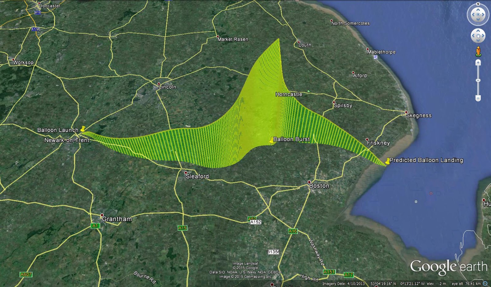
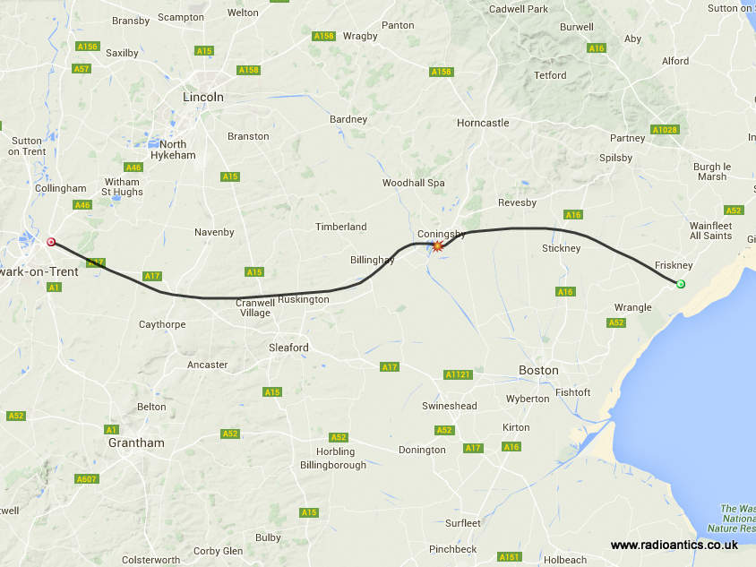
This is the predicted flight path, generated by the CUSG Landing predictor at predict.habhub.org and the flight path currently goes directly over RAF Cranwell but not at a high enough altitude.
 |
| Flight prediction for Friday |
 |
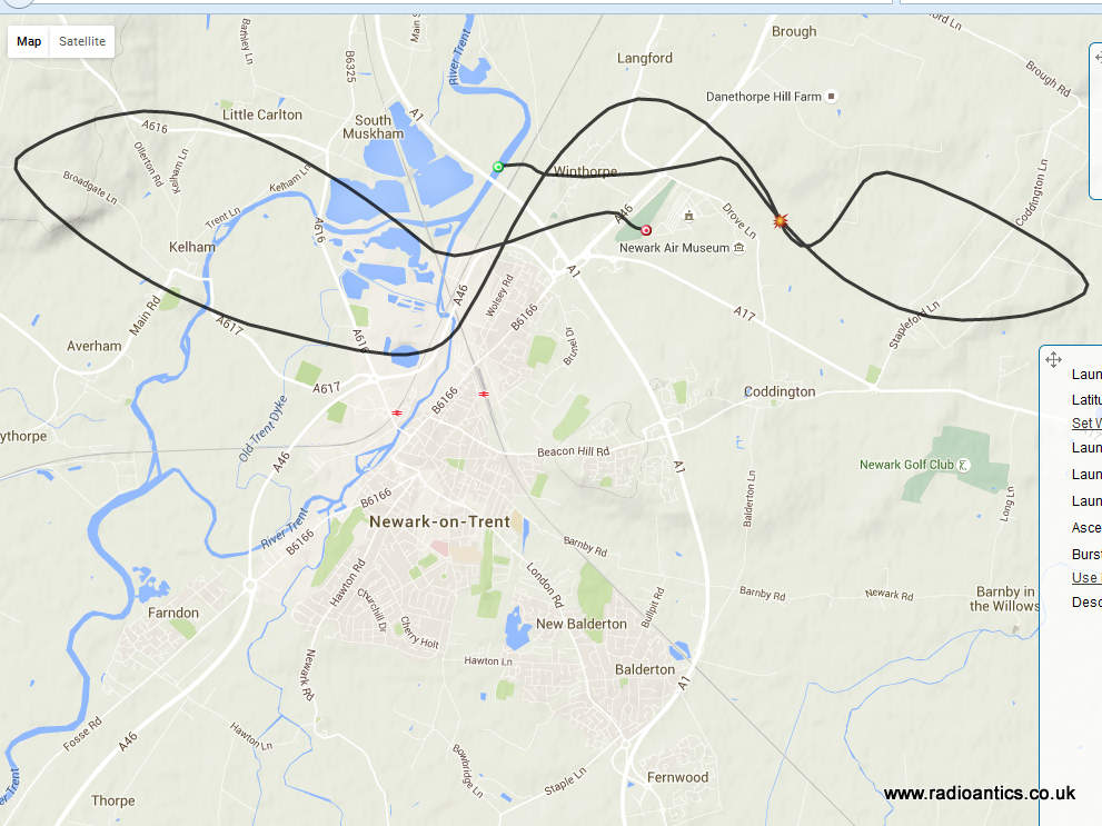
| Flight prediction for Saturday |
There would be no issues with the airfields for that flight path and has the advantage of going almost straight up and landing close by.
Apologies to those wanting to track on Friday, but the situation is out of my control and I would be foolhardy to ignore the prediction and it is very unlikely it will change significantly to allow a flight tomorrow so I hope you can all track on Saturday. I will still be at the Hamfest tomorrow with the equipment if you want to know more about what it is all about.
Andrew Garratt, MØNRD, is a regular contributor to AmateurRadio.com and writes from East Midlands, England. Contact him at [email protected].
Hamfest HAB Launch likely to be postponed to Saturday
The forecast for tomorrow is strong gusty winds at ground level which isn't ideal for launching, but that is the least of the issues.
The current flight predictions for tomorrow are not good. The prediction model used is accurate and for the size of balloon I have and the amount of helium at my disposal even a maximum fill giving the maximum ascent rate and assuming the calculated decent rate for the parachute it is still putting the likely landing right on the coast. Earlier in the week the landing wasn't quite as marginal but as the model's data set have been updated it has drifted further eastward, it is odds on it will actually land out to sea.
However the real show stopper was when I received the CAA approval for the launch this morning. They have put a restriction not permitting a launch if the balloon and payload is likely to go on a North Easterly or Easterly path that could interfere with operations on local military airfields.
This is the predicted flight path, generated by the CUSG Landing predictor at predict.habhub.org and the flight path currently goes directly over RAF Cranwell but not at a high enough altitude.
|
| Flight prediction for Friday |
|
| Flight prediction for Saturday |
There would be no issues with the airfields for that flight path and has the advantage of going almost straight up and landing close by.
Apologies to those wanting to track on Friday, but the situation is out of my control and I would be foolhardy to ignore the prediction and it is very unlikely it will change significantly to allow a flight tomorrow so I hope you can all track on Saturday. I will still be at the Hamfest tomorrow with the equipment if you want to know more about what it is all about.
Andrew Garratt, MØNRD, is a regular contributor to AmateurRadio.com and writes from East Midlands, England. Contact him at [email protected].
Answers to Top 10 Amateur Radio Questions on Social Media
With questions omitted:
10. No, that’s not a contest you heard on that WARC band.
9. You should probably study.
8. Yes, the bands are dead and it’s not your rig/antenna/coax/ears/QTH.
7. Whatever rig/logging program/medication best fits your needs.
6. No, not all young people are lazy.
5. Yes, that QSL/awards system is a PITA, but you’ll eventually figure it out like we did.
4. It just is.
3. Yes, we’ve heard the LIDs on that frequency and, no, you’re not the first person to hear them. Yes, the FCC knows about them, and no, you’re not going to stop them with your crusade/monitoring/recordings/complaints/hand-wringing/prayer group.
2. No one shops at that store anymore. Yes, it sucks and has for several decades. Don’t go to that store.
1. Google.
Anthony, K3NG, is a regular contributor to AmateurRadio.com.
Lightwave Scatter Planning
Over the past few days I've been trying to figure out some possible pathways that might be covered when transmitting from home.
The only real directions that I can go any distances are towards the southwest and to the southeast because of two large hills (500' and 900') to the south.
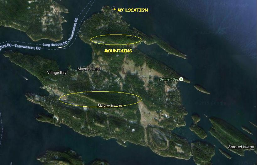 |
| courtesy: https://www.google.ca/maps |
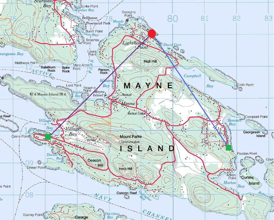 |
| courtesy: http://www.jeffstopos.com/ |
The challenge will be to put a signal over this 500' hill, about 1.5 km to the south ... I'll need to go around it on either side or over the top. Going around it at its edges will allow me to keep the light beam on a fairly low angle.
The main obstacle is my lot ... it is heavily treed in these directions and aiming would have to be too high of an angle to get over the trees. I do however, have one small gap between the trees which has turned out to be close to the right bearing (220 degrees) for the southwest test. For this, I can set the transmitter on my back sundeck and shoot through the gap without bothering anyone. For the southeast shot, or one over the top,of the hill, I'll need to move the transmitter two lots to the east of me, and use the neighbour's clear view of the hill.
This should work out OK, as the neighbour spends the winter in Boston and the house is vacant ... but the outside power sockets are alive. This path though, has me shooting across a small bay and above several houses. Most are summer residents only but there are a couple that are permanent. I'll need to contact them and give them a 'heads-up' before I run any tests, so they don't call the RCMP!
The June 2014 edition of Radcom has an inspiring article by G3XBM, "Over The Horizon At 481THz", where Roger describes his early clear air scatter tests and excellent results over an 8.5 km path. This is a very impressive distance considering the small LED transmitter and 4" magnifying-glass lenses used.
Unfortunately, the distances here, on both paths, are not very much ... about 5 km. I'm fairly limited to how far I can go here on the island. I'd be very happy to cover this comparatively short distance and a lot will depend on being able to keep a low enough angle and still get over the hill.
With the right weather, I may start as one reader has suggested, with a short almost vertical incidence shot and set up a few blocks away to test out the system.
Steve McDonald, VE7SL, is a regular contributor to AmateurRadio.com and writes from British Columbia, Canada. Contact him at [email protected].
Hamfest HAB – Pre Launch Update
Balloon, parachute and helium have all been purchased and payloads have under gone final testing and have been put to one side ready for the flight which should hopefully be around 12pm on Friday 25th September.
The SSDV payload callsign PINKY will transmit on 434.575MHz USB RTTY 300 baud 880Hz shift ASCII-8 no parity 2 stop bits.
 |
| SSDV Test image |
They will transmit using the UKHAS telemetry protocol and can be tracked on tracker.habhub.org for information on how to receive and upload data to the tracking system visit the UKHAS wiki some information and useful links have been collated on the AMSAT-UK website
I was hoping to also transmit using the LoRa system, using the callsign PERKY. The transmitter had been successfully tested but a last minute gremlin has struck and it stopped working this weekend, I have been unable to locate the fault and suspect it is the actual module and with time being short have all but given up getting it working. If I do get it working it will be on 434.450MHz in Mode 1
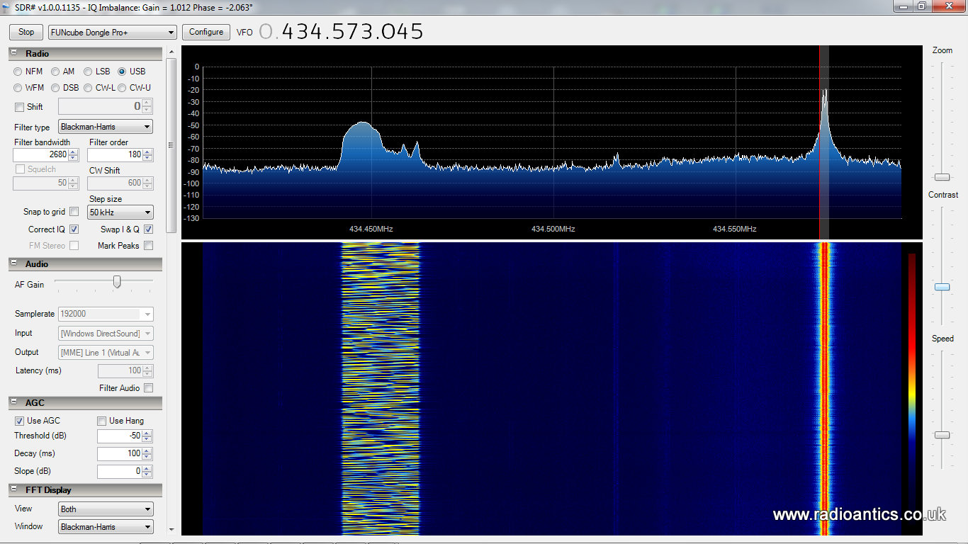 |
| PERKY seen working on SDR |
 |
| PINKY & PERKY tracker |

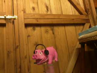
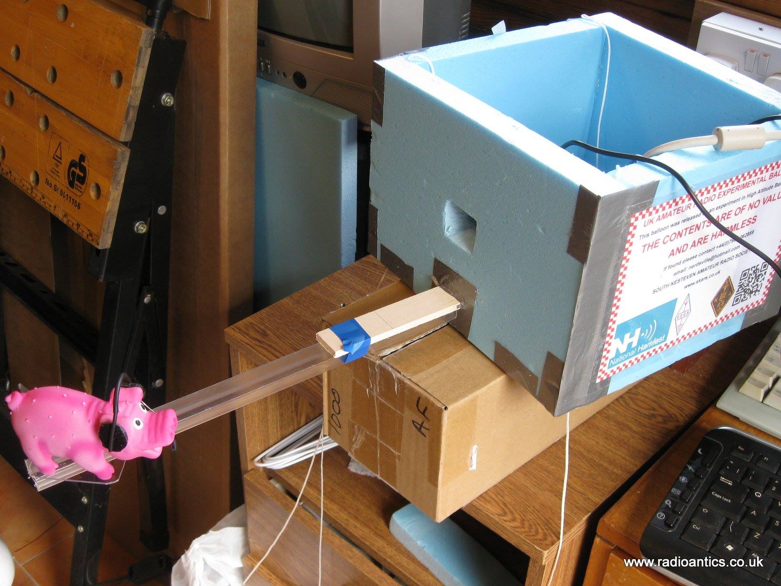
"Pinky" pig will be the passenger on the day, donning his fetching headset. Getting him in the right position for the camera was tricky.
I am still waiting for the CAA approval, should hopefully get it soon. I have put in a request for both days of the Hamfest just in case, the latest prediction at predict.habhub.org shows if I get the fill right I might just escape a watery landing on Friday, however Saturday looks more promising at the moment - also the forecast for Friday at the moment also has strong gusty surface winds, which could make the launch problematic. I am still planning for Friday since conditions and predictions do change.
 |
| Friday prediction as of 22/09/2015 |
 |
| Saturday prediction as of 22/09/2015 |
Please don't mention anything to do with other pigs in the news..
Andrew Garratt, MØNRD, is a regular contributor to AmateurRadio.com and writes from East Midlands, England. Contact him at [email protected].
Hamfest HAB – Pre Launch Update
Balloon, parachute and helium have all been purchased and payloads have under gone final testing and have been put to one side ready for the flight which should hopefully be around 12pm on Friday 25th September.
The SSDV payload callsign PINKY will transmit on 434.575MHz USB RTTY 300 baud 880Hz shift ASCII-8 no parity 2 stop bits.
|
| SSDV Test image |
They will transmit using the UKHAS telemetry protocol and can be tracked on tracker.habhub.org for information on how to receive and upload data to the tracking system visit the UKHAS wiki some information and useful links have been collated on the AMSAT-UK website
I was hoping to also transmit using the LoRa system, using the callsign PERKY. The transmitter had been successfully tested but a last minute gremlin has struck and it stopped working this weekend, I have been unable to locate the fault and suspect it is the actual module and with time being short have all but given up getting it working. If I do get it working it will be on 434.450MHz in Mode 1
|
| PERKY seen working on SDR |
|
| PINKY & PERKY tracker |
"Pinky" pig will be the passenger on the day, donning his fetching headset. Getting him in the right position for the camera was tricky.
I am still waiting for the CAA approval, should hopefully get it soon. I have put in a request for both days of the Hamfest just in case, the latest prediction at predict.habhub.org shows if I get the fill right I might just escape a watery landing on Friday, however Saturday looks more promising at the moment - also the forecast for Friday at the moment also has strong gusty surface winds, which could make the launch problematic. I am still planning for Friday since conditions and predictions do change.
|
| Friday prediction as of 22/09/2015 |
|
| Saturday prediction as of 22/09/2015 |
Please don't mention anything to do with other pigs in the news..
Andrew Garratt, MØNRD, is a regular contributor to AmateurRadio.com and writes from East Midlands, England. Contact him at [email protected].
CLE 198 Results
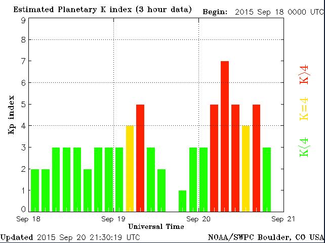 |
| courtesy: http://www.swpc.noaa.gov/ |
For those looking to log Hawaii on the NDB band, 'POA' on 332 kHz is a good bet as it had a strong signal here on all three nights and was heard shortly after sunset in Hawaii.
------------------------------------------------------------------------------------
DD UTC kHz Call mi New Location
--------------------------------------------------------------------------------
19 11:00 323 HJH 1393 Hebron Municipal Apt, NE, USA
19 10:00 325 YJQ 312 Bella Bella (Campbell Island), BC, CAN
19 12:00 326 XJ 522 Fort St. John, BC, CAN
19 09:00 326 MA 1594 FARLY - Midland, TX, USA
20 04:00 326 FO 1531 'Riply' Topeka, KS, USA
19 10:00 326 DC 131 Princeton Municipal Apt, BC, CAN
19 12:00 328 LAC 133 'Lacomas' Fort Lewis, WA, USA
19 12:00 328 5J 564 Coronation, AB, CAN
20 05:00 329 YHN 1730 Hornepayne, ON, CAN
19 12:00 329 YEK 1414 Arviat, NU, CAN
19 12:00 329 X2 590 Athabasca, AB, CAN
19 12:00 329 TAD 1240 Trinidad - Hoehne, CO, USA
19 10:00 329 PMV 1437 Plattsmouth, NE, USA
19 12:00 329 PJ 920 Robinson (Whitehorse), YT, CAN
21 09:00 329 HMA 1851 Hondo Municipal Apt, TX, USA
19 08:00 332 XT 442 Terrace, BC, CAN
19 08:00 332 XH 565 Medicine Hat, AB, CAN
19 08:00 332 WC 25 White Rock (Abbotsford), BC, CAN
20 04:00 332 VVV 1280 Ortonville Municipal Apt, MN, USA
19 08:00 332 POA 2681 Pahoa - Hawaii Island, HWA
20 05:00 332 FIS 2794 Fish Hook - Key West, FL, USA
19 08:00 333 STI 540 'Sturgeon' Mountain Home, ID, USA
19 08:00 334 P2 514 Wetaskiwin, AB, CAN
------------------------------------------------------------------------------------
As usual, all stations were heard using the Perseus SDR.
Hopefully CLE 199 will see the return of quieter band conditions and better propagation ... if the sun can calm down long enough.
Steve McDonald, VE7SL, is a regular contributor to AmateurRadio.com and writes from British Columbia, Canada. Contact him at [email protected].
 Ham Radio Deluxe |
 W5SWL Electronics |
 Ham Radio Prep |
 KB3IFH QSL Cards  Hip Ham Shirts  HamRadioAuctions HamRadioAuctions Reliance Antennas Reliance Antennas Enigma Shop Enigma Shop |  morseDX  Ni4L Antennas  R&L Electronics R&L Electronics antennas.us antennas.us QRV QRV |
- Matt W1MST, Managing Editor
