 A Christmas Eve Summit Activation
My wife, Cris, and I are staying in New Mexico for the holidays and our kids don't arrive until Christmas Day. So what better time for a SOTA activation than Christmas Eve, right. This time of year, the higher elevation peaks and thus the higher point value peaks have too much snow on them to make access practical. So in Santa Fe that means some of the peaks in the 7,000 - 8,000 ft ASL are much more accessible this time of year.
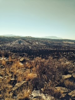
The Sierra De Las Valles Range, west of Santa Fe, feature many peaks in the mid 7,000's. The range is located in the Caja del Rio (Spanish: "box of the river"). Caja Del Rio is a dissected plateau, of volcanic origin, which covers approximately 84,000 acres of land in northern Santa Fe County, New Mexico. The drainage from this region empties into the Rio Grande River. The center of the area is approximately 15 miles west of Santa Fe. Most of the Caja is owned by the U. S. Forest Service and managed by the Santa Fe National Forest. Access is through New Mexico Highway 599, Santa Fe County Road 62, and Forest Service Road 24.
I decided to climb Montoso Peak, which at 7,315 ft. ASL is one of the tallest peaks in the Caja and Cris decided to come along for the hike. The climb is not particularly tough, other than there are no trails. The climb is 100% bushwhack and volcanic boulders and cactus are the primary obstacles. From where we parked our Jeep, we had a 640 foot vertical ascent over a one mile hike. It took us about 40 minutes to get to the top.
Mike Crownover, AD5A, is a regular contributor to AmateurRadio.com and writes from Texas, USA. Contact him at [email protected].The Sierra De Las Valles Range, west of Santa Fe, feature many peaks in the mid 7,000's. The range is located in the Caja del Rio (Spanish: "box of the river"). Caja Del Rio is a dissected plateau, of volcanic origin, which covers approximately 84,000 acres of land in northern Santa Fe County, New Mexico. The drainage from this region empties into the Rio Grande River. The center of the area is approximately 15 miles west of Santa Fe. Most of the Caja is owned by the U. S. Forest Service and managed by the Santa Fe National Forest. Access is through New Mexico Highway 599, Santa Fe County Road 62, and Forest Service Road 24.
I decided to climb Montoso Peak, which at 7,315 ft. ASL is one of the tallest peaks in the Caja and Cris decided to come along for the hike. The climb is not particularly tough, other than there are no trails. The climb is 100% bushwhack and volcanic boulders and cactus are the primary obstacles. From where we parked our Jeep, we had a 640 foot vertical ascent over a one mile hike. It took us about 40 minutes to get to the top.
View from the Top
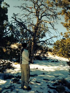
Once on top I set up the station, a KD1JV designed ATS4-B, a 4 band CW only QRP rig and a 20m/40M End Fed Half Wave. I hang one end of the antenna over a tree branch, usually about 20 feet up, and run the antenna wire to a 21 foot carbon fiber, telescoping, pole. Below you see a photo of me deploying the antenna by elevating the end of the antenna (on an orange winder just visible in the picture) over a limb using the fishing pole. The winder, once over the limb, falls to earth, I secure the end, then attach the antenna wire to my fishing pole, running the wire down to within 6 feet of the ground. I anchor the matching device to the pole, hook up the coax and away I go. The wire is an L configuration with the shortest leg coming down the pole. I usually just prop the fishing pole on one of the evergreen trees if available, rather than guy it..
Deploying the Antenna
Once set up, the chaser pile-up was great. Signals were good, I got good reports and even squeezed in a little DX, working EA2LU on 20m. I ended up with 36 QSO's, 29 on 20m, 5 on 40m and 2 on 15m in a little over 30 minutes on the air. Below you see my operating position. The orange Velcro wrap, just up the pole is where the antenna matching device is anchored.
My Operating Position
It was a beautiful day for a hike. Not a cloud in the sky and the temps were in the mid 30's with very little wind, warming into the 40's by the end of the activation. We did not see any wildlife, however we saw lots of Elk tracks. The local name for the peak is Bear Mountain, however we saw no bears or bear prints on this trip. I wisely did not inform Cris of this "local" name until we were descending the mountain.


Nice report!
Interesting terrain …. nice antenna information.