 |
 Long night

Description:
This class is designed for those auxiliary emergency communicators and groups who volunteer to provide backup emergency radio communications support to public safety agencies. Typically, this includes amateur radio and Radio Emergency Associated Communications Team (REACT) communicators, but may include other volunteer emergency communicators.
Volunteer emergency communications operators/groups, using amateur radio, have been providing backup communications to public safety for nearly 100 years. Event planners, public safety officials, and emergency managers at all levels of government utilize their services. Often, amateur radio services have been used when other forms of communications have failed or have been disrupted. Today, nearly all the states/territories have incorporated some level of participation by amateur radio auxiliary communication operators into their TICPs and SCIPs.
This course focuses on auxiliary communications interoperability, the relationship between the COML and the volunteer, emergency operations center (EOC) etiquette, on-the-air etiquette, FCC rules and regulations, auxiliary communications training and planning, and emergency communications deployment. It is intended to supplement and standardize an operator’s experience and knowledge of emergency amateur radio communications in a public safety context.
It's a two day event, held over the weekend of October 24th and 25th at the Middlesex County Fire Academy. Looks to be interesting. My registration was received and accepted pending my sending in the certificates of completion, which I sent in this morning.
The FEMA courses were comprehensive in scope. Each was designed to be completed in about 3 hours and I came in slightly under that amount of time - maybe two and a half hours or two hours and forty five minutes each.
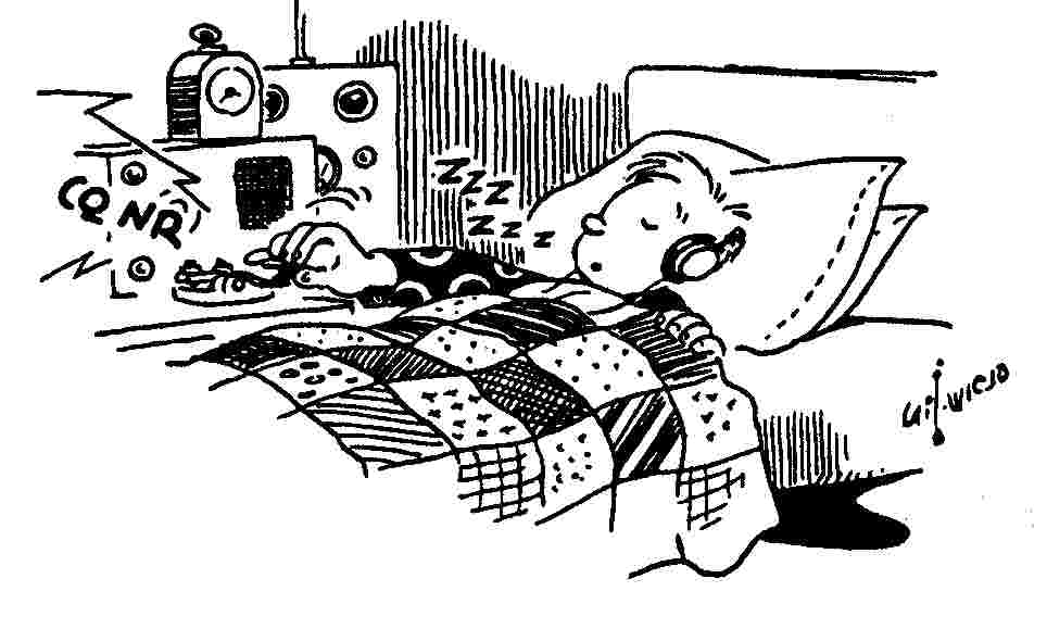
I crammed two in last night (which wasn't wise) as each evening for the rest of this week is booked with other activities. I was pretty bleary eyed for that last exam, but was pleased when I got the e-mail that I passed.
FEMA offers a lot of free, on-line independent study courses. You can look them up at https://training.fema.gov/is/crslist.aspx?all=true
72 de Larry W2LJ
QRP - When you care to send the very least!
Larry Makoski, W2LJ, is a regular contributor to AmateurRadio.com and writes from New Jersey, USA. Contact him at [email protected].
The VE3KCL Balloons

From the website of Hans Summers (GØUPL) comes news of a 3rd balloon launch from Canada.
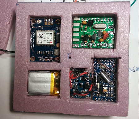
David, VE3KCL, used a special U3 firmware version of one of the kits available from QRP Labs and an Arduino Nano board driven by a QRP Labs Si5351A Synthesizer board. Special WSPR codes were used for vehicle telemetry which sent Callsign, Power, Locator, Altitude, Temperature, Battery, Groundspeed, GPS Status and Satellites Found. A 30m HF data download link was used with the help of a full-sized dipole hung between the system's two support balloons as well as a CW identifier on several other bands.
Hans describes the system used:
David VE3KCL launched his third balloon flight S-3 on 28-Jul-2015 at about 11:40Z. Like the former S-2 flight, this one also uses a special U3 firmware version on an Arduino Nano board, with QRP Labs Si5351A Synthesiser. Two foil "party" balloons were used, filled with hydrogen. The earlier balloons S-1 and S-2 apparently suffered burst failure before reaching float altitude due to polluted gas mix - there was a lot of propane mixed in with the hydrogen. This flight S-3 successfully climbed to almost 8,000m so this problem is now solved.
The transmission schedule includes CW on several different bands (for the reverse CW network), 30m JT9 and a special WSPR message on 30m. The special WSPR message types encodes two additional WSPR messages which contain the additional 5th and 6th character of the locator, altitude, battery voltage, temperature, ground speed, GPS status, and number of GPS satellites (a single bit, 0 means under 8, and 1 means 8 or more). The "special" WSPR transmissions therefore show up in the WSPR database with locators and powers which are not the actual locator and power, but encode the additional data. The conversion back to actual flight data is done later in an Excel spreadsheet. This is very experimental at the moment.
 |
| courtesy: VE3KCL, GØUPL and https://www.google.ca/ |
 |
| courtesy: VE3KCL and http://www.qrp-labs.com/ |
More information and pictures of VE3KCL's adventures can be viewed on the QRP Labs website. For those who are software-savvy, it looks like a simple system could be put together with some of the available kits.
PS-46 UPDATE
On another note, it does appear that Andy's amazing Pico-Sat balloon did indeed go down, south of Madagascar, after almost completing its 3rd circumnavigation of the globe.
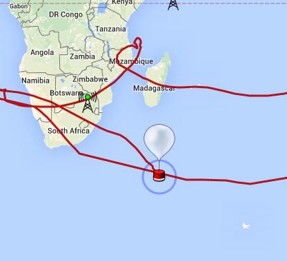 |
| courtesy: http://spacenear.us |
Steve McDonald, VE7SL, is a regular contributor to AmateurRadio.com and writes from British Columbia, Canada. Contact him at [email protected].
Radio antics on the Inner Hebrides
It was our fourth visit to Skye but Islay was a new destination for us. While it was primarily a holiday away with the wife and dogs doing some walking, sight-seeing, visiting the numerous malt whisky distilleries (especially on Islay and Jura) I also planned to do some operating.
Last year I did operate from the same rented cottage on Skye but this year I wanted to do some portable working on both islands. With this in mind and following my disappointment last month I had taken time to properly prepare. As well as repairing the end-fed wire "magitenna" that had caused issues last time out I had constructed a linked dipole for 40m/20m for a simple inverted-vee using a fibreglass windsock pole.
I took the Yaesu FT857-D with a small SLA battery for portable work and a small power supply when in the cottages. Unfortunately things didn't get off to a good start when I dropped the battery when unpacking. I had used a small screw-terminal chock block to connect to the power loom and the weight of the battery simply ripped both wires out of the terminal block and they touched with an almighty spark and welded themselves together. I acted quickly to remove them from the battery but it has almost certainly affected the battery. Despite this set back the battery performance proved more than sufficient for my needs.
During the first week on Skye, the South Kesteven ARS, which I am the chairman, had their monthly meeting and we planned to try and make a scheduled contact (sked) I did have a run through one evening to test the set up and antenna, drinking a beer and making contacts while sitting on a bench at the cottage watching the sunset going down over Loch Bay with the Outer Hebrides in the distance - sheer bliss!


On the night of the sked the famous Scottish midges were out in abundance and I opted to work from inside the cottage. A successful contact and conversation was made even if there were a few issues at the club that night. They were unable to get the planned antenna up due to activities in the nearby scout hut but like all good hams they improvised using an Ampro-40 magmounted vertical on top of a large saucepan until they were able to get a dipole up but by then band conditions had started deteriorating, but a contact is a contact.
Going portable I had planned to do some Worked All Britain Award activations, the W.A.B scheme uses the Ordnance Survey (OS) mapping agencies National Grid Reference (NGR) system to divide the country into 10km x 10km grid squares. The aim is for activators to operate from the squares and for other operators to “work” those squares.
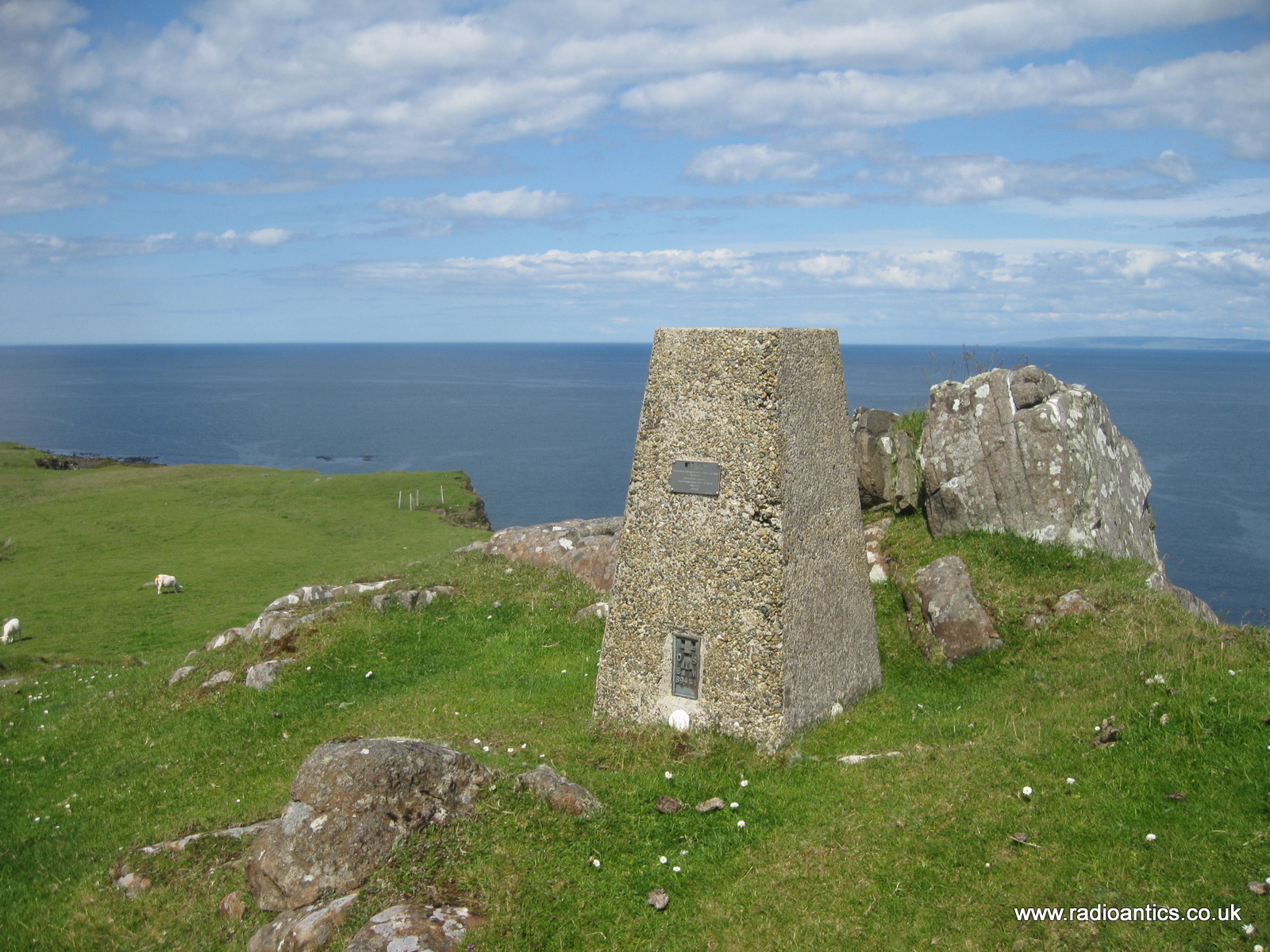
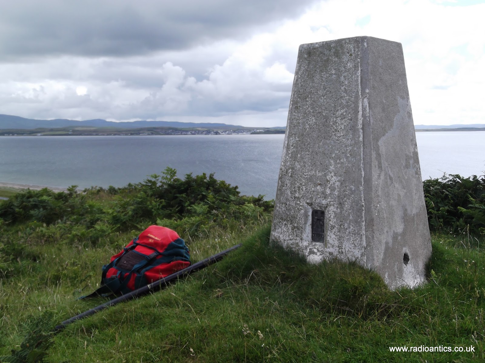
In addition to activating squares, operators can also activate pillar type triangulation points (commonly known as 'Trig Points') which were originally used to carry out the surveying for Ordnance Survey maps but have now been abandoned and have become interesting relics and many are now sadly falling into disrepair, however many people still seek them out and a database exists at www.trigpointing.uk
I planned to try to activate some squares and trig points as the more remote locations such as the Scottish Islands are highly sort after as they don’t get activated as often.
Firstly before I describe my adventures let me be brutally honest! I am fat, in fact very fat and unfit!
I haven’t always in such poor shape, in fact I used to be a keen walker regularly going out at weekends walking miles and even completed several long distance footpaths, including The Coast to Coast Walk back in 1991. I then spent many years competing in dog agility most weekends which kept me reasonably fit but the last few years circumstances have changed and I now have a sedentary lifestyle and desk bound job. This coupled with stress, apathy and being a more than willing victim of comfort eating mean I have piled on the pounds.
Why make this confession? Simply because most trig points are on prominent hill tops and high ground throughout the country and therefore will require some physical climbing to get to them. I was under no illusion there were many on Skye and Islay that I stood no chance of reaching without some form of coronary episode! But I had identified a number of more attainable ones requiring on paper just a modest exertion.
How wrong I was..
On the Isle of Skye we were staying on the Waternish peninsular and I had identified two possible candidates the nearby Ben Horneval (TP1275) and Ben Geary (TP1269) while both were over 260 meters in height the maps and descriptions seemed to indicate reasonable but still strenuous approaches. However prior to us arriving the weather had been very wet and the ground was very boggy and when actually standing looking up at the hills I sensibly thought "Not a chance!"
Instead I opted to go to the coast, specifically Talisker Bay which is glorious and simply activate a WAB square NG33 while the wife and dogs occupied themselves on the beach. So off we went, drove across Skye and walked the mile or so from the parking area carrying the rucksack with radio and pole. I went of to a nice spot just up of the beach to set up to then discover I had forgotten to pack the coax... never mind had a good few hours on the beach and stopped off at the Talisker distillery on the way back.

There were a number of suggested approaches, on the first we were met with fences, livestock and a sign saying private and seeing no obvious path up we investigated another through a gate on the main road. This was more straightforward however the nearest parking area was a little way down from the gate. The road was extremely busy and we weren’t comfortable trying to walk up the road with the dogs due to the traffic. I was feeling at little peeved at this point and opted to stay with the car while the wife retrieved the cache and took a photo so I know what I missed.
In the end I made no trig point activations on the Isle of Skye, but should we go back at least I am more prepared.
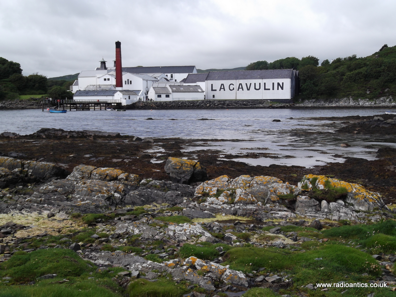
The second week of our holiday was on Islay. Islay is simply a fantastic place to visit, much quieter than Skye, probably due to the two hour ferry journey involved and I did manage some portable operating between visiting the eight whisky distilleries and a trip to a ninth on nearby Jura.
The cottage we were staying in overlooked Lagavulin Bay with the Lagavulin Distillery and the remains of Dunyvaig Castle, it was a two minute walk to a high point near the ruins where I set up one evening and had an hour operating in the setting sun, again band conditions were poor but I didn't care, NR44 was activated.


There were two trig-points quite near to the cottage. Ardmore Point (TP0875), from the map this looked simple enough, however the road to Ardmore was a private road so couldn’t take the car and while walking there from the nearest parking space was simple enough time didn’t allow it.
Cnoc Rhaonastil (TP2293) was another potential trig point, locally called the Fairy Hill it promised spectacular views for short but steep walk, however again parking and access proved problematic and so was never attempted.
The Mull of Oa (TP4976) trig-point I actually walked to being next to the American Monument which commemorates the loss of two troop ships in 1918, the Tuscania and the Otranto and the spectacular location overlooks the very spot where the Tuscania sunk. The monument built to thank the inhabitants of Islay for their help is built in the shape of a lighthouse and is visible from many areas on Islay. Despite the very wet ground conditions the walk was straightforward however the weather put paid to any attempt at activating. The wind was very very strong, as this short video demonstrates.
The attempt on An Curran (TP0839) really was a comedy of errors, being a fairly modest 49m high and close to where we were staying it should have been straightforward. To get to the summit you have to navigate a dense conifer forest and I had read the description on the trigpointing.uk website of how to ascend via a gate and distinct path.
It looked short and simple so didn't take a map or the GPS with me. I found a gate and what seemed like a path along a wall and set off and quickly the path became indistinct and the trees were indeed very dense, so dense I was struggling to get through them. But I carried on going up gaining altitude thinking I must be nearing the top, however it got to the point I just couldn’t get through the trees anymore and there was no sign of them thinning out as they supposedly did at the summit. It started raining and was having to negotiate water filled hollows, heather and bracken hummocks and swarms of midges - this was not fun!
Eventually I did spot a clearing only to find it was where a power line ran up the hillside. I knew I was too far south and since going north through the forest was neigh on impossible I instead descended following the power line through chest high bracken back to the road, all the time worrying about "Serpents" as the locals quaintly called the adders which were prevalent this year. When I did reach the road I had to climb a low dry stone wall and promptly slipped into a deep water filled ditch on the other side, losing a boot in the peaty mud much to the amusement of a passing group of horse riders.

I almost decided that this was enough, I was doomed not to activate a trig point however one remained on the hit list and I succeeded in activating it on the final day.
I had spotted Cnoc Lolairean (TP2283) when visiting the nearby Bruichladdich Distillery earlier in the week, only 29 meters high it was on a small ridge along the side of Loch Indaal and it involved just a short walk up a farm track and up a narrow track to the top.
The wife went of to get a coffee from the nearby mini-market and took the dogs for a walk on the nearby beach while I went to the trig point. What it lacked in height it made up for with the position with fantastic view across to Bowmore and down the Loch.
I used bungee cords to hold the pole to the pillar and soon had the inverted-vee up on 40m. I had around 40 minutes of operating, and band conditions were again poor with lots of noise but I did make a decent number of contacts running approximately 20W before the battery voltage started to drop off. I was especially pleased to work Stewart M0SDM a fellow SKARS member.


Andrew Garratt, MØNRD, is a regular contributor to AmateurRadio.com and writes from East Midlands, England. Contact him at [email protected].
Radio antics on the Inner Hebrides
It was our fourth visit to Skye but Islay was a new destination for us. While it was primarily a holiday away with the wife and dogs doing some walking, sight-seeing, visiting the numerous malt whisky distilleries (especially on Islay and Jura) I also planned to do some operating.
Last year I did operate from the same rented cottage on Skye but this year I wanted to do some portable working on both islands. With this in mind and following my disappointment last month I had taken time to properly prepare. As well as repairing the end-fed wire "magitenna" that had caused issues last time out I had constructed a linked dipole for 40m/20m for a simple inverted-vee using a fibreglass windsock pole.
I took the Yaesu FT857-D with a small SLA battery for portable work and a small power supply when in the cottages. Unfortunately things didn't get off to a good start when I dropped the battery when unpacking. I had used a small screw-terminal chock block to connect to the power loom and the weight of the battery simply ripped both wires out of the terminal block and they touched with an almighty spark and welded themselves together. I acted quickly to remove them from the battery but it has almost certainly affected the battery. Despite this set back the battery performance proved more than sufficient for my needs.
During the first week on Skye, the South Kesteven ARS, which I am the chairman, had their monthly meeting and we planned to try and make a scheduled contact (sked) I did have a run through one evening to test the set up and antenna, drinking a beer and making contacts while sitting on a bench at the cottage watching the sunset going down over Loch Bay with the Outer Hebrides in the distance - sheer bliss!
On the night of the sked the famous Scottish midges were out in abundance and I opted to work from inside the cottage. A successful contact and conversation was made even if there were a few issues at the club that night. They were unable to get the planned antenna up due to activities in the nearby scout hut but like all good hams they improvised using an Ampro-40 magmounted vertical on top of a large saucepan until they were able to get a dipole up but by then band conditions had started deteriorating, but a contact is a contact.
Going portable I had planned to do some Worked All Britain Award activations, the W.A.B scheme uses the Ordnance Survey (OS) mapping agencies National Grid Reference (NGR) system to divide the country into 10km x 10km grid squares. The aim is for activators to operate from the squares and for other operators to “work” those squares.
In addition to activating squares, operators can also activate pillar type triangulation points (commonly known as 'Trig Points') which were originally used to carry out the surveying for Ordnance Survey maps but have now been abandoned and have become interesting relics and many are now sadly falling into disrepair, however many people still seek them out and a database exists at www.trigpointing.uk
I planned to try to activate some squares and trig points as the more remote locations such as the Scottish Islands are highly sort after as they don’t get activated as often.
Firstly before I describe my adventures let me be brutally honest! I am fat, in fact very fat and unfit!
I haven’t always in such poor shape, in fact I used to be a keen walker regularly going out at weekends walking miles and even completed several long distance footpaths, including The Coast to Coast Walk back in 1991. I then spent many years competing in dog agility most weekends which kept me reasonably fit but the last few years circumstances have changed and I now have a sedentary lifestyle and desk bound job. This coupled with stress, apathy and being a more than willing victim of comfort eating mean I have piled on the pounds.
Why make this confession? Simply because most trig points are on prominent hill tops and high ground throughout the country and therefore will require some physical climbing to get to them. I was under no illusion there were many on Skye and Islay that I stood no chance of reaching without some form of coronary episode! But I had identified a number of more attainable ones requiring on paper just a modest exertion.
How wrong I was..
On the Isle of Skye we were staying on the Waternish peninsular and I had identified two possible candidates the nearby Ben Horneval (TP1275) and Ben Geary (TP1269) while both were over 260 meters in height the maps and descriptions seemed to indicate reasonable but still strenuous approaches. However prior to us arriving the weather had been very wet and the ground was very boggy and when actually standing looking up at the hills I sensibly thought "Not a chance!"
Instead I opted to go to the coast, specifically Talisker Bay which is glorious and simply activate a WAB square NG33 while the wife and dogs occupied themselves on the beach. So off we went, drove across Skye and walked the mile or so from the parking area carrying the rucksack with radio and pole. I went of to a nice spot just up of the beach to set up to then discover I had forgotten to pack the coax... never mind had a good few hours on the beach and stopped off at the Talisker distillery on the way back.
There were a number of suggested approaches, on the first we were met with fences, livestock and a sign saying private and seeing no obvious path up we investigated another through a gate on the main road. This was more straightforward however the nearest parking area was a little way down from the gate. The road was extremely busy and we weren’t comfortable trying to walk up the road with the dogs due to the traffic. I was feeling at little peeved at this point and opted to stay with the car while the wife retrieved the cache and took a photo so I know what I missed.
In the end I made no trig point activations on the Isle of Skye, but should we go back at least I am more prepared.
The second week of our holiday was on Islay. Islay is simply a fantastic place to visit, much quieter than Skye, probably due to the two hour ferry journey involved and I did manage some portable operating between visiting the eight whisky distilleries and a trip to a ninth on nearby Jura.
The cottage we were staying in overlooked Lagavulin Bay with the Lagavulin Distillery and the remains of Dunyvaig Castle, it was a two minute walk to a high point near the ruins where I set up one evening and had an hour operating in the setting sun, again band conditions were poor but I didn't care, NR44 was activated.
There were two trig-points quite near to the cottage. Ardmore Point (TP0875), from the map this looked simple enough, however the road to Ardmore was a private road so couldn’t take the car and while walking there from the nearest parking space was simple enough time didn’t allow it.
Cnoc Rhaonastil (TP2293) was another potential trig point, locally called the Fairy Hill it promised spectacular views for short but steep walk, however again parking and access proved problematic and so was never attempted.
The Mull of Oa (TP4976) trig-point I actually walked to being next to the American Monument which commemorates the loss of two troop ships in 1918, the Tuscania and the Otranto and the spectacular location overlooks the very spot where the Tuscania sunk. The monument built to thank the inhabitants of Islay for their help is built in the shape of a lighthouse and is visible from many areas on Islay. Despite the very wet ground conditions the walk was straightforward however the weather put paid to any attempt at activating. The wind was very very strong, as this short video demonstrates.
The attempt on An Curran (TP0839) really was a comedy of errors, being a fairly modest 49m high and close to where we were staying it should have been straightforward. To get to the summit you have to navigate a dense conifer forest and I had read the description on the trigpointing.uk website of how to ascend via a gate and distinct path.
It looked short and simple so didn't take a map or the GPS with me. I found a gate and what seemed like a path along a wall and set off and quickly the path became indistinct and the trees were indeed very dense, so dense I was struggling to get through them. But I carried on going up gaining altitude thinking I must be nearing the top, however it got to the point I just couldn’t get through the trees anymore and there was no sign of them thinning out as they supposedly did at the summit. It started raining and was having to negotiate water filled hollows, heather and bracken hummocks and swarms of midges - this was not fun!
Eventually I did spot a clearing only to find it was where a power line ran up the hillside. I knew I was too far south and since going north through the forest was neigh on impossible I instead descended following the power line through chest high bracken back to the road, all the time worrying about "Serpents" as the locals quaintly called the adders which were prevalent this year. When I did reach the road I had to climb a low dry stone wall and promptly slipped into a deep water filled ditch on the other side, losing a boot in the peaty mud much to the amusement of a passing group of horse riders.
I almost decided that this was enough, I was doomed not to activate a trig point however one remained on the hit list and I succeeded in activating it on the final day.
I had spotted Cnoc Lolairean (TP2283) when visiting the nearby Bruichladdich Distillery earlier in the week, only 29 meters high it was on a small ridge along the side of Loch Indaal and it involved just a short walk up a farm track and up a narrow track to the top.
The wife went of to get a coffee from the nearby mini-market and took the dogs for a walk on the nearby beach while I went to the trig point. What it lacked in height it made up for with the position with fantastic view across to Bowmore and down the Loch.
I used bungee cords to hold the pole to the pillar and soon had the inverted-vee up on 40m. I had around 40 minutes of operating, and band conditions were again poor with lots of noise but I did make a decent number of contacts running approximately 20W before the battery voltage started to drop off. I was especially pleased to work Stewart M0SDM a fellow SKARS member.
Andrew Garratt, MØNRD, is a regular contributor to AmateurRadio.com and writes from East Midlands, England. Contact him at [email protected].
Ham Radio Jepperdee

There is great entertainment value in ABC-TV’s Jeopardy! program. This author sees educational opportunities everywhere; wouldn’t it be great to be able to play a game like this for a club program or for a review session after a licensing- exam course? A student at Siena College provided a template for a quiz game in PowerPoint; our junque box was large enough for construction to proceed. After two full evenings at the workbench, Ham-Radio Jepperdee was born.
My hardware includes push-buttons, lock-out circuitry, lights, and a sounder. DC power is provided by a wall-wart to terminals shown as circles on the left edge of the schematic. I have constructed both a 6-volt version and a 12-volt version of Jepperdee, and I’m currently building a second 12-volt unit. (I gave one to a cousin who is a teacher.)

The electromechanical relays at the heart of the project are not state-of the-art, but they were immediately available. Anyone wishing to build a device like mine may choose to use solid-state circuitry. The speaker symbol on the right of the figure is used to denote an attention-getting alarm.
Although it can stand alone, my quiz-game gadgetry is more fun when paired with Ham-Radio Jepperdee PowerPoint software. Submitted along with this article is a complete game file. Slides 1 and 2 are introductory; slide 3 is instructional; slide 4 is the circuit diagram (perhaps worth describing during a presentation); slides 5 and 6 are the game boards. The rest of the slides complete the game, and they include many features of the familiar TV show.
Left-clicking on any numerical entry on the game board yields a question; the very next frame gives the answer. [Exception: a player may get the Daily Double banner; the slide gives on-screen instructions.] It requires almost no effort to change the wording on any frame of the PowerPoint; the game can be changed as drastically as necessary to suit any purpose.
Ham-Radio Jepperdee (attached) is meant to be entertaining. On ARRL’s web site at http://www.arrl.org/instruction-exam-practice-and-review, one can find several exam-prep Jepperdee games whose questions have been taken from current question pools. These are entertaining and educational.
Bob Raffaele, W2XM, is a special contributor to AmateurRadio.com and writes from New York, USA. Contact him at [email protected].
The Joy Of CW
 |
| courtesy: http://www.arrl.org/ |
I receive a lot of e-mail from both hams and future hams that are struggling with CW. It seems there are a lot of hams that don't operate any CW simply because of their code skills. For myself, learning CW as a pre-teen, was a bit of a struggle, as I learned CW from flash cards ... definitely the wrong way. In my case, the code was learned in order to operate an Aldis lamp signalling system for my scouting activities. When eventually switching to a hand key and buzzer, I had to make the mental switch between the picture of the flash card and the sound of the code, taking me much longer to reach my goals than if I had learned just by sound.
If I were learning the code today, or if advising anyone struggling with CW, I would suggest several ways of making it easier.
1. Too many newcomers want to learn CW using a keyer. Put the keyer away and get yourself a hand key. It need not be fancy or expensive.
2. Use the hand key to practice sending similar-sounding letters (E, I, S, H etc) slowly and correctly. Don't be concerned about sending them fast but concentrate on getting a uniform spacing between each element of the letter. As you slowly learn the letters and how they sound, you will find your sending speeding-up, unconsciously, as you progress.
3. Combine your sending practice with receiving practice and try to do 10 minutes of each during each practice session. One session per day will guarantee success, if you stick with it. If you can't do it every day then try and commit to every other day.
4. For receiving practice, use a much higher speed than what you are sending at. Once again, in sets of similar-sounding letters, try and learn the letters when sent at a speed of at least 15WPM, but with wide spaces between each letter ... so they aren't coming at you as fast. This is the Farnsworth method of learning code. Learning what the letters sound like when sent at a fast speed will eliminate the dreaded 'learning plateaus' associated with learning at slower speeds, when you can get stuck at a lower speed for some length of time. I only wish that I had known of this method when I was a kid, but I don't think it had been thought of back then.
5. There are lots of websites that will help you in Step 4 and one that I have played with seems to work very well. You can set up a slow-speed spacing but have characters sent at 15WPM or faster (start with 15WPM). You can pick only the letters that you wish to practice (T,M,O,A,N etc) and then get a printout of what was actually sent to check your accuracy. The one I tested is by AA9PW and can be found here.
In addition, the ARRL's W1AW, provides nightly code practice on various frequencies and also provides archived CW practice sessions at various speeds via their website here.
Once you become somewhat competent in both sending and receiving, don't be afraid to get on the air and use your new skills. Don't be concerned about sending fast and be careful about sending faster than you can receive, an easy trap to fall into.
There are always several stations around 7.110-7.125 every afternoon and evening that seem very happy to communicate at comfortable speeds. If you don't get on-the-air, then make sure that you still do your daily 20 minutes of practice. You will be amazed at how quickly you can learn the code or increase your speed, with this daily routine. This short daily commitment to practice (on the air or otherwise) is the key to success.
If you aren't using CW, you are missing out on a lot of fun. To this day, CW is still my favorite mode and almost 100% of my on-air operating is on CW ... it's just plain fun! Knowing how to use CW will open up a lot of opportunities to enjoy it ... CW contesting, chasing DX, CW nets, staying in touch with friends etc ... CW will always get through better than phone under most conditions.
 |
| courtesy: http://www.arrl.org/ |
So ... if you have been struggling with the code, or putting it off, there's no time like the present to join the fun. Hopefully you will find these suggestions helpful.
Steve McDonald, VE7SL, is a regular contributor to AmateurRadio.com and writes from British Columbia, Canada. Contact him at [email protected].
Weekly Propagation Summary – 2015 Jul 27 16:10 UTC

Here is this week’s space weather and geophysical report, issued 2015 Jul 27 0117 UTC.
Highlights of Solar and Geomagnetic Activity 20 – 26 July 2015
Solar activity reached low levels this period. Region 2389 (S11, L=164, class/area=Dai/80 on 25 Jul) produced three low-level C-class flares throughout the period which were the largest observed events. Region 2389 produced a C1 flare at 24/0315 UTC, a C2/Sf flare at 24/1444 UTC, and a C1 flare at 26/1234 UTC but none of these events resulted in coronal mass ejections (CMEs) that were Earth-directed. Region 2390 (S15, L=198, class/area=Dac/130 on 26 Jul) underwent moderate penumbral development and increased in magnetic complexity late in the period, but remained largely unproductive. No Earth-directed CMEs were detected in SOHO/LASCO coronagraph imagery throughout the period.
No proton events were observed at geosynchronous orbit.
The greater than 2 MeV electron flux at geosynchronous orbit reached high levels on 20, 26 Jul with moderate levels observed on 21-22, and 24-25 Jul. The electron flux decreased to normal levels on 23 Jul in response to enhanced geomagnetic field activity attributed to a combination of CME and coronal hole high speed stream (CH HSS) influence.
Geomagnetic field activity reached active to G1 (Minor) geomagnetic storm levels on 23 Jul due to a combination of the arrival of the 19 Jul CME (filament eruption) and the onset of a weak positive polarity CH HSS. Active conditions were observed at 23/0300-0600 UTC and 23/1800-2100 UTC and G1 storm conditions were observed at 23/0600-0900 UTC. The geomagnetic field was at quiet or quiet to unsettled levels for the remainder of the period under an ambient solar wind environment followed by weak CH HSS influence.
Forecast of Solar and Geomagnetic Activity 27 July – 22 August 2015
Solar activity is expected to be at very low to low levels throughout the period with a slight chance of M-class (R1-R2/Minor-Moderate) flare activity between 28 Jul-10 Aug due to the return of Region 2381 (N14, L=074) which produced two M-class flares last rotation.
No proton events are expected at geosynchronous orbit.
The greater than 2 MeV electron flux at geosynchronous orbit is expected to be at normal to moderate levels on 29 Jul, 01, 07, and 17 Aug with high levels expected throughout the remainder of the period.
Geomagnetic field activity is likely to reach G1 (Minor) geomagnetic storm levels on 07 Aug with active levels expected on 29 Jul, 02, 08-09, and 19 Aug, all in response to the influence of recurrent CH HSS. Quiet to unsettled geomagnetic field activity is expected throughout the remainder of the period under an ambient solar wind environment.
Don’t forget to visit our live space weather and radio propagation web site, at: http://SunSpotWatch.com/
Live Aurora mapping is at http://aurora.sunspotwatch.com/
If you are on Twitter, please follow these two users: + https://Twitter.com/NW7US + https://Twitter.com/hfradiospacewx
Get the space weather and radio propagation self-study course, today. Visit http://nw7us.us/swc for the latest sale and for more information!
Check out the stunning view of our Sun in action, as seen during the last five years with the Solar Dynamics Observatory (SDO): https://www.youtube.com/watch?v=zXN-MdoGM9g
We’re on Facebook: http://NW7US.us/swhfr
Visit, subscribe: NW7US Radio Communications and Propagation YouTube Channel
 Ham Radio Deluxe |
 W5SWL Electronics |
 Ham Radio Prep |
 KB3IFH QSL Cards  Hip Ham Shirts  HamRadioAuctions HamRadioAuctions Reliance Antennas Reliance Antennas Enigma Shop Enigma Shop |  morseDX  Ni4L Antennas  R&L Electronics R&L Electronics antennas.us antennas.us QRV QRV |
- Matt W1MST, Managing Editor
